Difference between revisions of "2023-04-18 64 25"
| Line 17: | Line 17: | ||
== Expedition == | == Expedition == | ||
| − | + | My plan was to leave from work and start cycling towards the hashpoint. | |
| + | Assuming that I would leave at 5 PM, I would have four hours until sunset and around 45 kilometres to cycle, so I would not be in any hurry. | ||
| + | The weather was going to be sunny, and the temperature would hover a few degrees above zero. | ||
| + | The snow cover was melting fast in Oulu, and the ground was getting exposed in forests, so I should be able to walk in the forest here too. | ||
| + | It can't be much worse in the countryside, nearly 20 kilometres inland, right? | ||
| + | Famous last words... | ||
| + | |||
| + | It took me until 6 PM to leave, but it was still not too late. | ||
| + | Everything started out all right: | ||
| + | the cycleways in the city were already clear of snow and grit and a real joy to cycle on after a long winter. | ||
| + | However, after getting through some suburbs and three geocaches, I tried to proceed on something that looked like a walkway on the map but ended up being a literal wall of snow that I could not get through. | ||
| + | My options were turning back or taking an icy trail that led towards the Vaalantie main road. | ||
| + | I chose the latter and ended up against a skiing track that I was in principle not supposed to follow. | ||
| + | It was, though, very worn down due to warm weather, and I could walk on the side pushing the bicycle, causing only negligible destruction. | ||
| + | I could see the road in front of me, on top of an earth bank and surrounded by guardrails and deep snow, here [https://goo.gl/maps/8CA24hoNz4W7guLA9]. | ||
| + | I stopped to curse out loud and to think how to get on the road; | ||
| + | I could go along the skiing track under the underpass or walk straight through the half-metre-deep snow to the northwestern end of the guardrail. | ||
| + | I again chose the latter and after a while could set the bicycle on the hard road surface and continue cycling. | ||
| + | |||
| + | After cycling another about 15 kilometres, I arrived at the intersection where a forest road began. | ||
| + | It was not in a good condition, consisting of an annoying combination of slush, ice and mud. | ||
| + | My skinny road tires were not suitable for that, but I could still go on. | ||
| + | A mountain bike or a fatbike would have fared better, but then riding a long distance on tarmac would have been tougher, so it's a compromise. | ||
| + | After crawling for what felt like an eternity, I finally parked the bicycle and got ready to walk. | ||
| + | There was a lot more snow than I had expected, more than half a metre in places. | ||
| + | I only had to traverse 280 metres, so I thought I could do it despite it being very tough. | ||
| + | I did not want to turn back after coming this far. | ||
| + | |||
| + | Slowly but surely, I got to the hashpoint which was at the border between sparse forest and a former logging area. | ||
| + | The deepest snow that I encountered was about 80 cm deep, and I could really appreciate the depth looking at my footprints on the way back. | ||
| + | I was surprisingly able to avoid getting my shoes wet until I stepped in a ditch just two metres before I would have been back on the muddy road again. | ||
| + | Somehow, I had stepped over the wet part on the way to the hashpoint and not got wet at all. | ||
| + | I had been wise and prepared myself with spare socks and shoes which I quickly changed into once I was standing on the road. | ||
| + | It was instantly much better, but my toes got a little cold and felt cold all the way until I got back home. | ||
| + | |||
| + | On the way back, I crossed the Oulujoki river and took a different route to end up in Mäntylä. | ||
| + | I did not want to stop much because I was feeling cold and because it was getting late. | ||
| + | I did stop to take a few pictures and to find a geocache in Maikkula. | ||
| + | The sun set at 21:05, and it began to very gradually get dark. | ||
| + | I was back at home just before 10 PM, cold and tired but satisfied. | ||
According to the GPS receiver, the length of the trip was 47.1 km, of which I cycled 46.1 km and walked 1.0 km in total. | According to the GPS receiver, the length of the trip was 47.1 km, of which I cycled 46.1 km and walked 1.0 km in total. | ||
== Tracklog == | == Tracklog == | ||
| + | Near the beginning of the trip, I visited two multicaches and a mystery geocache. | ||
| + | I cut a part of the tracklog away so I would not reveal their final locations. | ||
| + | |||
{{tracklog | 2023-04-18_64_25_tracklog.gpx}} | {{tracklog | 2023-04-18_64_25_tracklog.gpx}} | ||
== Photos == | == Photos == | ||
| − | < | + | <gallery perrow="9"> |
| − | Image: | + | Image:2023-04-18_64_25_01-oulujoki.jpg | The Oulujoki river. |
| − | -- | + | Image:2023-04-18_64_25_02-forestroad.jpg | Entering the forest road, 1.4 km to go. |
| − | + | Image:2023-04-18_64_25_03-bicycle.jpg | Where I parked the bicycle, 280 m to go. | |
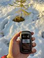
| + | Image:2023-04-18_64_25_04-gpsr1.jpg | Proof of location. | ||
| + | Image:2023-04-18_64_25_05-gpsr2.jpg | Proof of date and time. | ||
| + | Image:2023-04-18_64_25_06-selfie.jpg | Stupid Grin™ and the surroundings. | ||
| + | Image:2023-04-18_64_25_07-footprints.jpg | My footprints on the way back. The snow was up to 80 cm deep. | ||
| + | Image:2023-04-18_64_25_08-field.jpg | View to fields and a horse stable near Turkka. | ||
| + | Image:2023-04-18_64_25_09-sanginjoki.jpg | The Sanginjoki river, still frozen, but I would not walk there. | ||
</gallery> | </gallery> | ||
| Line 44: | Line 92: | ||
__NOTOC__ | __NOTOC__ | ||
| − | |||
| − | |||
| − | |||
| − | |||
| − | |||
| − | |||
| − | |||
| − | |||
| − | |||
| − | |||
| − | |||
| − | |||
| − | |||
[[Category:Expeditions]] | [[Category:Expeditions]] | ||
| − | |||
[[Category:Expeditions with photos]] | [[Category:Expeditions with photos]] | ||
| − | |||
| − | |||
| − | |||
| − | |||
| − | |||
[[Category:Coordinates reached]] | [[Category:Coordinates reached]] | ||
| − | |||
| − | |||
| − | |||
| − | |||
| − | |||
| − | |||
| − | |||
| − | |||
| − | |||
| − | |||
| − | |||
| − | |||
| − | |||
| − | |||
| − | |||
| − | |||
| − | |||
| − | |||
Revision as of 18:53, 19 April 2023
| Tue 18 Apr 2023 in 64,25: 64.9152046, 25.8544306 geohashing.info google osm bing/os kml crox |
Location
In a forest in Eerikkikangas, Lapinkangas, Oulu.
The point on a topographic map: [1]
Participants
Expedition
My plan was to leave from work and start cycling towards the hashpoint. Assuming that I would leave at 5 PM, I would have four hours until sunset and around 45 kilometres to cycle, so I would not be in any hurry. The weather was going to be sunny, and the temperature would hover a few degrees above zero. The snow cover was melting fast in Oulu, and the ground was getting exposed in forests, so I should be able to walk in the forest here too. It can't be much worse in the countryside, nearly 20 kilometres inland, right? Famous last words...
It took me until 6 PM to leave, but it was still not too late. Everything started out all right: the cycleways in the city were already clear of snow and grit and a real joy to cycle on after a long winter. However, after getting through some suburbs and three geocaches, I tried to proceed on something that looked like a walkway on the map but ended up being a literal wall of snow that I could not get through. My options were turning back or taking an icy trail that led towards the Vaalantie main road. I chose the latter and ended up against a skiing track that I was in principle not supposed to follow. It was, though, very worn down due to warm weather, and I could walk on the side pushing the bicycle, causing only negligible destruction. I could see the road in front of me, on top of an earth bank and surrounded by guardrails and deep snow, here [2]. I stopped to curse out loud and to think how to get on the road; I could go along the skiing track under the underpass or walk straight through the half-metre-deep snow to the northwestern end of the guardrail. I again chose the latter and after a while could set the bicycle on the hard road surface and continue cycling.
After cycling another about 15 kilometres, I arrived at the intersection where a forest road began. It was not in a good condition, consisting of an annoying combination of slush, ice and mud. My skinny road tires were not suitable for that, but I could still go on. A mountain bike or a fatbike would have fared better, but then riding a long distance on tarmac would have been tougher, so it's a compromise. After crawling for what felt like an eternity, I finally parked the bicycle and got ready to walk. There was a lot more snow than I had expected, more than half a metre in places. I only had to traverse 280 metres, so I thought I could do it despite it being very tough. I did not want to turn back after coming this far.
Slowly but surely, I got to the hashpoint which was at the border between sparse forest and a former logging area. The deepest snow that I encountered was about 80 cm deep, and I could really appreciate the depth looking at my footprints on the way back. I was surprisingly able to avoid getting my shoes wet until I stepped in a ditch just two metres before I would have been back on the muddy road again. Somehow, I had stepped over the wet part on the way to the hashpoint and not got wet at all. I had been wise and prepared myself with spare socks and shoes which I quickly changed into once I was standing on the road. It was instantly much better, but my toes got a little cold and felt cold all the way until I got back home.
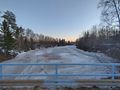
On the way back, I crossed the Oulujoki river and took a different route to end up in Mäntylä. I did not want to stop much because I was feeling cold and because it was getting late. I did stop to take a few pictures and to find a geocache in Maikkula. The sun set at 21:05, and it began to very gradually get dark. I was back at home just before 10 PM, cold and tired but satisfied.
According to the GPS receiver, the length of the trip was 47.1 km, of which I cycled 46.1 km and walked 1.0 km in total.
Tracklog
Near the beginning of the trip, I visited two multicaches and a mystery geocache. I cut a part of the tracklog away so I would not reveal their final locations.
Photos
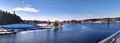
The Oulujoki river.
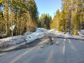
Entering the forest road, 1.4 km to go.
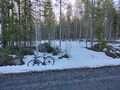
Where I parked the bicycle, 280 m to go.
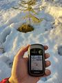
Proof of location.
Proof of date and time.
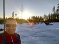
Stupid Grin™ and the surroundings.
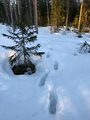
My footprints on the way back. The snow was up to 80 cm deep.
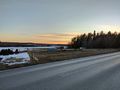
View to fields and a horse stable near Turkka.
The Sanginjoki river, still frozen, but I would not walk there.


Achievements
Kripakko earned the Land geohash achievement
|
Kripakko earned the Bicycle geohash achievement
|