Difference between revisions of "2023-04-21 -36 145"
([retro picture]Success) |
m |
||
| (10 intermediate revisions by 4 users not shown) | |||
| Line 1: | Line 1: | ||
| − | + | {{meetup graticule | |
| − | |||
| − | |||
| − | |||
| − | |||
| − | |||
| − | |||
| − | |||
| − | |||
| lat=-36 | | lat=-36 | ||
| lon=145 | | lon=145 | ||
| date=2023-04-21 | | date=2023-04-21 | ||
| − | }} | + | }} |
== Location == | == Location == | ||
| − | + | In a field near Nathalia. | |
== Participants == | == Participants == | ||
| − | + | *[[User:Lachie|Lachie]] | |
| − | |||
== Plans == | == Plans == | ||
| − | + | Lachlan was in the midst of a four day cycle tour from Swan Hill to Bendigo. The day of the hash was day 2 of the tour which should have been about 110km but was extended to ~140km due to road closures from floods. When the coordinates came out Lachlan noticed they would only be about a 20km detour from the planned route. Not trusting himself Lachlan messaged several geohashers that he might do the hash to acquire some external accountability. | |
== Expedition == | == Expedition == | ||
| − | + | Lachlan woke up in a tent on the banks of Gunbower Creek near the twin cities of Koondrook/Barham. He set off along the dirt road along the creek and enjoyed the misty sunrise. Second breakfast presented it self in Cohuna and then Lachlan was back to following the creek. The road through Daltons Bridge was truly delightful, but it did deteriarate into a mud track somewhere around the Murray. | |
| + | Sadly the beautiful roads along waterways were not to last and there was about 30km of highway to get to Echuca for lunch. After an icecream, a pie, etc. it was back on to beautiful waterways up to Nathalia, where Lachlan found the hash in a field. | ||
| − | + | From there it was another 20 odd km to the house of some friends which marked the end of bike riding for the day. | |
| − | |||
== Tracklog == | == Tracklog == | ||
| − | + | {{ Tracklog | 2023-04-21 -36 145 trace.gpx }} | |
== Photos == | == Photos == | ||
| − | |||
| − | |||
| − | |||
<gallery perrow="5"> | <gallery perrow="5"> | ||
| + | Image:2023-04-21_-36_145_lachie_1682723564467.jpg|Success | ||
| + | Image:2023-04-21_-36_145_lachie_1682723590638.jpg|Proof <!-- This has to be the worst proof picture ever, good that there is a tracklog :D -Fippe --> | ||
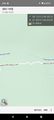
| + | Image:2023-04-21_-36_145_lachie_1682723590638.jpg|Better GPS Proof - thanks [[User:Fippe|Fippe]] ;) | ||
| − | Image:2023-04-21_- | + | Image:2023-04-21_-36_145_lachie_1684983598431.jpg|Proof of something relevant. |
| + | Geohash 2023-04-21 -36 145 GPS proof.png | ||
</gallery> | </gallery> | ||
| Line 46: | Line 38: | ||
__NOTOC__ | __NOTOC__ | ||
| − | |||
| − | |||
| − | |||
| − | |||
| − | |||
| − | |||
| − | |||
| − | |||
| − | |||
| − | |||
| − | |||
| − | |||
| − | |||
| − | |||
[[Category:Expeditions]] | [[Category:Expeditions]] | ||
| − | |||
[[Category:Expeditions with photos]] | [[Category:Expeditions with photos]] | ||
| − | |||
| − | |||
| − | |||
| − | |||
| − | |||
[[Category:Coordinates reached]] | [[Category:Coordinates reached]] | ||
| − | + | {{location|AU|VIC|MI}} | |
| − | |||
| − | |||
| − | |||
| − | |||
| − | |||
| − | |||
| − | |||
| − | |||
| − | |||
| − | |||
| − | |||
| − | |||
| − | |||
| − | |||
| − | |||
| − | |||
| − | |||
Latest revision as of 15:33, 25 May 2023
| Fri 21 Apr 2023 in -36,145: -36.0701308, 145.1732329 geohashing.info google osm bing/os kml crox |
Location
In a field near Nathalia.
Participants
Plans
Lachlan was in the midst of a four day cycle tour from Swan Hill to Bendigo. The day of the hash was day 2 of the tour which should have been about 110km but was extended to ~140km due to road closures from floods. When the coordinates came out Lachlan noticed they would only be about a 20km detour from the planned route. Not trusting himself Lachlan messaged several geohashers that he might do the hash to acquire some external accountability.
Expedition
Lachlan woke up in a tent on the banks of Gunbower Creek near the twin cities of Koondrook/Barham. He set off along the dirt road along the creek and enjoyed the misty sunrise. Second breakfast presented it self in Cohuna and then Lachlan was back to following the creek. The road through Daltons Bridge was truly delightful, but it did deteriarate into a mud track somewhere around the Murray.
Sadly the beautiful roads along waterways were not to last and there was about 30km of highway to get to Echuca for lunch. After an icecream, a pie, etc. it was back on to beautiful waterways up to Nathalia, where Lachlan found the hash in a field.
From there it was another 20 odd km to the house of some friends which marked the end of bike riding for the day.
Tracklog
Photos
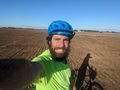
Success
Proof
Better GPS Proof - thanks Fippe ;)

Proof of something relevant.