Difference between revisions of "2023-04-30 44 -117"
Michael5000 (talk | contribs) |
Michael5000 (talk | contribs) |
||
| Line 18: | Line 18: | ||
== Photos == | == Photos == | ||
| − | |||
| − | |||
| − | |||
<gallery perrow="5"> | <gallery perrow="5"> | ||
| + | File:2023-04-30 44 -177 a.jpg|Optimism was riding high as we crossed the state line.... | ||
| + | File:2023-04-30 44 -177 b.jpg|No trespassin'. Trucks are on I-84 on the Oregon side. | ||
| + | File:2023-04-30 44 -177 c.jpg|From I-84 a few hours later: a train rolls by the hashpoint. | ||
</gallery> | </gallery> | ||
| Line 31: | Line 31: | ||
__NOTOC__ | __NOTOC__ | ||
| − | |||
| − | |||
| − | |||
| − | |||
| − | |||
| − | |||
| − | |||
| − | |||
| − | |||
| − | |||
| − | |||
| − | |||
| − | |||
[[Category:Expeditions]] | [[Category:Expeditions]] | ||
| − | |||
[[Category:Expeditions with photos]] | [[Category:Expeditions with photos]] | ||
| − | |||
| − | |||
| − | |||
| − | |||
| − | |||
| − | |||
| − | |||
| − | |||
| − | |||
[[Category:Coordinates not reached]] | [[Category:Coordinates not reached]] | ||
| − | |||
| − | |||
| − | |||
| − | |||
| − | |||
[[Category:Not reached - No public access]] | [[Category:Not reached - No public access]] | ||
| − | |||
| − | |||
| − | |||
| − | |||
| − | |||
| − | |||
| − | |||
| − | |||
Revision as of 20:14, 1 May 2023
| Sun 30 Apr 2023 in 44,-117: 44.2720289, -117.1922920 geohashing.info google osm bing/os kml crox |
Location
On the Idaho bank of the Snake River west of Weiser.
Participants
Expedition
After two days where everything went pretty much exactly to plan for five expeditions, I headed north from an overnight stop in Ontario thinking that this one was a gimme: drive up, cross railroad tracks, head down to the riverbank, collect hashpoint. So of course this is the one that I couldn't get to.
The issue was that the railroad was protected by the most serious fencing and signage that I've seen on a rural line. That is probably mostly about keeping livestock off the tracks in a relatively rich area of open range, and perhaps about keeping recreationalists getting stuck on the tracks trying to get their boats or jetskis from the road to the river. But, it was serious enough that I couldn't ignore it in good conscience for geohashing purposes.
While I was checking out the area, some folks drove up to the gate closest to the hashpoint, idled there for a minute or two, and then turned around and headed back to Weiser. It's exactly what it would have looked like if somebody else had also decided to give today's hashpoint a try. But I bet that wasn't the case.
Photos
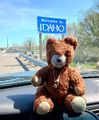
Optimism was riding high as we crossed the state line....
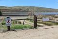
No trespassin'. Trucks are on I-84 on the Oregon side.
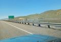
From I-84 a few hours later: a train rolls by the hashpoint.


Achievements
- I've failed twice now in the Baker City graticule, both times for fairly quirky access issues. Third time will doubtless be a charm.