Difference between revisions of "2023-05-06 46 -122"
(An expedition message sent via Geohash Droid for Android.) |
(9:22 am - before Michael5k, at a guess) |
||
| (16 intermediate revisions by 3 users not shown) | |||
| Line 11: | Line 11: | ||
| lon=-122 | | lon=-122 | ||
| date=2023-05-06 | | date=2023-05-06 | ||
| + | | graticule_name=Mt. St. Helens | ||
| + | | graticule_link=Mt. St. Helens, Washington | ||
}}<!-- edit as necessary --> | }}<!-- edit as necessary --> | ||
== Location == | == Location == | ||
| − | + | By the rail grade behind a dairy in Chehalis. | |
== Participants == | == Participants == | ||
| − | + | *[[User:Thomcat|Thomcat]] | |
| − | + | *[[user:Michael5000|Michael5000]] | |
== Plans == | == Plans == | ||
| Line 23: | Line 25: | ||
== Expedition == | == Expedition == | ||
| − | + | '''Thomcat''' | |
| + | Wasn't even considering this until the folks on Discord pointed out it would be easy - so this became the first of three expeditions on Saturday. | ||
| + | |||
| + | Left Seattle about 7:30 am, though I originally planned to leave earlier. Not quite XKCD-100, this one was 96 miles from my driveway. Saw two Chehalis signs on the way in, apparently shot the darker one :) The time was 9:22 am. | ||
| + | |||
| + | Parked north of the point, by the "The Farm Store" - goods for the farm and from the farm, but not actually farms for sale. | ||
| + | |||
| + | Railroad tracks are usually "not public" but saw no restricting signs. Walked down the tracks past the building south of said store. Some sort of liquid processing plant, with tanks and sluices. The three parked rail cars were labeled "corn oil". | ||
| + | |||
| + | South of that was a large electric box, and next to that someone spelled out "DJ Salty Nuts" in rusty rail spikes. Sometimes the expedition theme just finds itself... just south of that were some more rusty spikes, so I grabbed four for an "X". | ||
| + | |||
| + | Further south was the correct latitude, and according to my phone, the proper point was just west of the tracks. I went slightly down slope and left an "X" to mark my location, then leaned into the brush to get within 2 meters. It was at that point that I glanced up and saw a sign saying "no trespassing" on the tracks. Ha! | ||
| + | |||
| + | It was also at that point that a large freight barreled down those same tracks, causing a fair amount of wind. From down the slope I watched it roll by, hoping there would be no derailments today. There weren't, I survived, and walked north up those same tracks to return to the car. Expedition success! | ||
| + | |||
| + | Next stop, North Bonneville and [[2023-05-06 45 -121]] | ||
| + | |||
| + | '''Michael5000''' | ||
| + | |||
| + | It didn't occur to me that anyone else might be visiting Chehalis railroad tracks on a rainy Saturday. I drove up from Portland, went for a run on the nearby Willapa Hills Trail, and made a rather cursory trek across the dairy's parking lot to the hashpoint. I completely failed to see any evidence of other geohashers, either because I got there the firstest or because I got there the mostest oblivious. | ||
| + | |||
| + | Then I drove home! | ||
== Tracklog == | == Tracklog == | ||
| Line 33: | Line 56: | ||
--> | --> | ||
<gallery perrow="5"> | <gallery perrow="5"> | ||
| + | |||
| + | Image:2023-05-06_46_-122_thomcat_1683390172120.jpg|Chehalis [https://openstreetmap.org/?mlat=46.66118020&mlon=-122.97263380&zoom=16 @46.6612,-122.9726] | ||
| + | |||
| + | Image:2023-05-06_46_-122_thomcat_1683390474088.jpg|DJ Salty Nuts [https://openstreetmap.org/?mlat=46.65912120&mlon=-122.97114420&zoom=16 @46.6591,-122.9711] | ||
| + | |||
| + | Image:2023-05-06_46_-122_thomcat_1683390616157.jpg|X close [https://openstreetmap.org/?mlat=46.65885920&mlon=-122.97122620&zoom=16 @46.6589,-122.9712] | ||
| + | |||
| + | Image:2023-05-06_46_-122_thomcat_1683390657999.jpg|West of X [https://openstreetmap.org/?mlat=46.65885990&mlon=-122.97122120&zoom=16 @46.6589,-122.9712] | ||
| + | |||
| + | Image:2023-05-06_46_-122_thomcat_1683390717394.jpg|Geohasher [https://openstreetmap.org/?mlat=46.65887050&mlon=-122.97122860&zoom=16 @46.6589,-122.9712] | ||
| + | |||
| + | Image:2023-05-06_46_-122_thomcat_1683390759252.jpg|Train [https://openstreetmap.org/?mlat=46.65886510&mlon=-122.97122920&zoom=16 @46.6589,-122.9712] | ||
| + | |||
| + | Image:2023-05-06_46_-122_thomcat_1683390896248.jpg|Plant [https://openstreetmap.org/?mlat=46.65886500&mlon=-122.97124410&zoom=16 @46.6589,-122.9712] | ||
| + | |||
| + | Image:2023-05-06_46_-122_thomcat_1683390996408.jpg|Plant [https://openstreetmap.org/?mlat=46.65917200&mlon=-122.97134010&zoom=16 @46.6592,-122.9713] | ||
| + | </gallery> | ||
| + | |||
| + | '''Michael5000 Gallery''' | ||
| + | <gallery perrow="5"> | ||
| + | File:2023-05-06 46 -122 1.jpg|Looking South. | ||
| + | File:2023-05-06 46 -122 2.jpg|Looking North. | ||
| + | File:2023-05-06 46 -122 3.jpg|Voila. | ||
</gallery> | </gallery> | ||
| Line 40: | Line 86: | ||
__NOTOC__ | __NOTOC__ | ||
| − | |||
| − | |||
| − | |||
| − | |||
| − | |||
| − | |||
| − | |||
| − | |||
| − | |||
| − | |||
| − | |||
| − | |||
| − | |||
| − | |||
[[Category:Expeditions]] | [[Category:Expeditions]] | ||
| − | |||
[[Category:Expeditions with photos]] | [[Category:Expeditions with photos]] | ||
| − | |||
| − | |||
| − | |||
| − | |||
| − | |||
[[Category:Coordinates reached]] | [[Category:Coordinates reached]] | ||
| − | + | {{location|US|WA|LE}} | |
| − | |||
| − | |||
| − | |||
| − | |||
| − | |||
| − | |||
| − | |||
| − | |||
| − | |||
| − | |||
| − | |||
| − | |||
| − | |||
| − | |||
| − | |||
| − | |||
| − | |||
Latest revision as of 14:32, 8 May 2023
| Sat 6 May 2023 in Mt. St. Helens: 46.6588556, -122.9712620 geohashing.info google osm bing/os kml crox |
Location
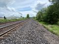
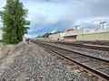
By the rail grade behind a dairy in Chehalis.
Participants
Plans
Expedition
Thomcat Wasn't even considering this until the folks on Discord pointed out it would be easy - so this became the first of three expeditions on Saturday.
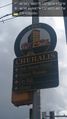
Left Seattle about 7:30 am, though I originally planned to leave earlier. Not quite XKCD-100, this one was 96 miles from my driveway. Saw two Chehalis signs on the way in, apparently shot the darker one :) The time was 9:22 am.
Parked north of the point, by the "The Farm Store" - goods for the farm and from the farm, but not actually farms for sale.
Railroad tracks are usually "not public" but saw no restricting signs. Walked down the tracks past the building south of said store. Some sort of liquid processing plant, with tanks and sluices. The three parked rail cars were labeled "corn oil".
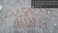
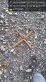
South of that was a large electric box, and next to that someone spelled out "DJ Salty Nuts" in rusty rail spikes. Sometimes the expedition theme just finds itself... just south of that were some more rusty spikes, so I grabbed four for an "X".
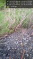
Further south was the correct latitude, and according to my phone, the proper point was just west of the tracks. I went slightly down slope and left an "X" to mark my location, then leaned into the brush to get within 2 meters. It was at that point that I glanced up and saw a sign saying "no trespassing" on the tracks. Ha!
It was also at that point that a large freight barreled down those same tracks, causing a fair amount of wind. From down the slope I watched it roll by, hoping there would be no derailments today. There weren't, I survived, and walked north up those same tracks to return to the car. Expedition success!
Next stop, North Bonneville and 2023-05-06 45 -121
Michael5000
It didn't occur to me that anyone else might be visiting Chehalis railroad tracks on a rainy Saturday. I drove up from Portland, went for a run on the nearby Willapa Hills Trail, and made a rather cursory trek across the dairy's parking lot to the hashpoint. I completely failed to see any evidence of other geohashers, either because I got there the firstest or because I got there the mostest oblivious.
Then I drove home!
Tracklog
Photos
Chehalis @46.6612,-122.9726
DJ Salty Nuts @46.6591,-122.9711
X close @46.6589,-122.9712
West of X @46.6589,-122.9712

Geohasher @46.6589,-122.9712
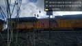
Train @46.6589,-122.9712
Plant @46.6589,-122.9712
Plant @46.6592,-122.9713


Michael5000 Gallery
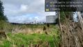
Looking South.
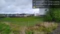
Looking North.

Voila.


