Difference between revisions of "2023-05-06 47 6"
(→Photos: Add photos) |
(→Achievements: Coordinates reached) |
||
| Line 28: | Line 28: | ||
File:2023-05-06 47 6 07.jpg | Surroundings (South) | File:2023-05-06 47 6 07.jpg | Surroundings (South) | ||
</gallery> | </gallery> | ||
| + | |||
| + | == Achievements == | ||
| + | {{#vardefine:ribbonwidth|100%}} | ||
| + | {{land geohash | ||
| + | | latitude = 47 | ||
| + | | longitude = 6 | ||
| + | | date = 2023-05-06 | ||
| + | | name = [[User:Baarde|Baarde]] | ||
| + | }} | ||
__NOTOC__ | __NOTOC__ | ||
[[Category:Expeditions]] | [[Category:Expeditions]] | ||
[[Category:Expeditions with photos]] | [[Category:Expeditions with photos]] | ||
| + | [[Category:Coordinates reached]] | ||
{{location|FR|90}} | {{location|FR|90}} | ||
Revision as of 13:58, 7 May 2023
| Sat 6 May 2023 in 47,6: 47.6588556, 6.9712620 geohashing.info google osm bing/os kml crox |
Location
At the edge of a forest in Lacollonge.
Participants
Plans
Baarde will take the train to Belfort then cycle to the coordinates.
Expedition
I had been looking for a meetup in the Besançon, France graticule for quite some time. Today's geohash looked fairly easy and squeezable in the 2-hour window between the outward and return trains, which was great for me. I had been donating platelets in the morning and was still wearing my regular clothes, so I didn't want to go on a long expedition.
I cycled from Belfort to Lacollonge. The coordinates were located by the side of a path at the entrance of a forest. After recording proof, I cycled back to Belfort.
Photos
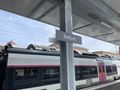
In Belfort
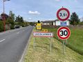
In Lacollonge
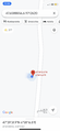
Coordinates reached
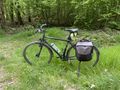
My bicycle at the coordinates
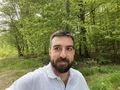
Stupid grin
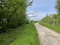
Surroundings (North)
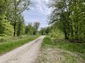
Surroundings (South)


Achievements
Baarde earned the Land geohash achievement
|