Difference between revisions of "2023-05-07 43 -79"
([retro picture]Lunch!) |
|||
| Line 1: | Line 1: | ||
| − | + | [[Image:{{{image|2023-05-07 43 -79 frogman 1683559319277.jpg}}}|thumb|left]] | |
| − | + | {{meetup graticule | |
| − | |||
| − | |||
| − | |||
| − | |||
| − | |||
| − | |||
| lat=43 | | lat=43 | ||
| lon=-79 | | lon=-79 | ||
| Line 13: | Line 7: | ||
}}<!-- edit as necessary --> | }}<!-- edit as necessary --> | ||
== Location == | == Location == | ||
| − | + | In Glendora Park in North York. | |
== Participants == | == Participants == | ||
| − | + | *[[User:Frogman|Frogman]] | |
| − | + | *[[User:Higgs|Higgs]] | |
| − | == | + | == Expedition == |
| − | + | [[User:Higgs|Higgs]] is visiting Toronto, and this easy geohash looked like a nice opportunity for a walk. We took the St. Clair streetcar to St. Clair station and then Line 1 north to Sheppard-Yonge station. From there it was a short walk east along Sheppard to a nice path that took us directly to Glendora Park, where the hashpoint is. As it was raining, we didn't hang out for too long. Our shoes were getting muddy! | |
| − | + | Afterwards we walked north along the same path to Lee Lifeson Art Park, a park dedicated to the two Rush members who grew up in North York. From there it was a short walk west to Yonge street and we stopped to eat in a restaurant that had some pretty good vegan shawarma. | |
| − | |||
| − | + | This hashpoint was fairly close to [[2019-06-23 43 -79]], a previous expedition of mine. | |
| − | |||
== Photos == | == Photos == | ||
| Line 49: | Line 41: | ||
== Achievements == | == Achievements == | ||
{{#vardefine:ribbonwidth|100%}} | {{#vardefine:ribbonwidth|100%}} | ||
| − | + | {{Public transport geohash | |
| − | + | | latitude = 43 | |
| − | + | | longitude = -79 | |
| − | + | | date = 2023-05-07 | |
| − | [[ | + | | busline = the TTC |
| + | | name = [[User:Frogman]] and [[User:Higgs]] | ||
| − | + | }} | |
| − | + | __NOTOC__ | |
| − | |||
| − | |||
| − | |||
| − | |||
| − | |||
| − | |||
[[Category:Expeditions]] | [[Category:Expeditions]] | ||
| − | |||
[[Category:Expeditions with photos]] | [[Category:Expeditions with photos]] | ||
| − | |||
| − | |||
| − | |||
| − | |||
| − | |||
[[Category:Coordinates reached]] | [[Category:Coordinates reached]] | ||
| − | |||
| − | |||
| − | |||
| − | |||
| − | |||
| − | |||
| − | |||
| − | |||
| − | |||
| − | |||
| − | |||
| − | |||
| − | |||
| − | |||
| − | |||
| − | |||
| − | |||
| − | |||
Revision as of 15:50, 10 May 2023

| Sun 7 May 2023 in 43,-79: 43.7611953, -79.4005838 geohashing.info google osm bing/os kml crox |
Location
In Glendora Park in North York.
Participants
Expedition
Higgs is visiting Toronto, and this easy geohash looked like a nice opportunity for a walk. We took the St. Clair streetcar to St. Clair station and then Line 1 north to Sheppard-Yonge station. From there it was a short walk east along Sheppard to a nice path that took us directly to Glendora Park, where the hashpoint is. As it was raining, we didn't hang out for too long. Our shoes were getting muddy!
Afterwards we walked north along the same path to Lee Lifeson Art Park, a park dedicated to the two Rush members who grew up in North York. From there it was a short walk west to Yonge street and we stopped to eat in a restaurant that had some pretty good vegan shawarma.
This hashpoint was fairly close to 2019-06-23 43 -79, a previous expedition of mine.
Photos
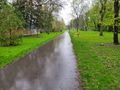
Path south of Sheppard
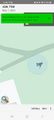
And here it is!
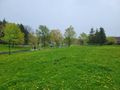
View from the hashpoint
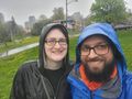
Us!
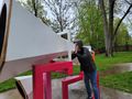
Checking out some sculptures
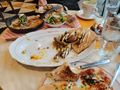
Lunch!


Achievements
User:Frogman and User:Higgs earned the Public transport geohash achievement
|