Difference between revisions of "2023-05-11 50 7"
Gefrierbrand (talk | contribs) ([live picture]proof) |
Gefrierbrand (talk | contribs) |
||
| Line 1: | Line 1: | ||
| − | + | {{meetup graticule | |
| − | |||
| − | |||
| − | |||
| − | |||
| − | |||
| − | |||
| − | |||
| − | |||
| lat=50 | | lat=50 | ||
| lon=7 | | lon=7 | ||
| date=2023-05-11 | | date=2023-05-11 | ||
| − | }} | + | }} |
== Location == | == Location == | ||
| − | + | Next to a small road near Niederfell | |
== Participants == | == Participants == | ||
| − | + | *[[User:Gefrierbrand|Gefrierbrand]] | |
| − | |||
| − | == | + | == Expedition == |
| − | + | First I was looking for some possibility to do this hash as a tron route, but the fact that i had to cross the Moselle river would have made this unreasonably complicated for a short evening expedition so I settled for simply going on an "almost tron" route after the bridge. | |
| − | + | As soon as I started unpacking my bike from the garage, some light rain started, but it wasn't that bad and since the weather had been mostly sunny before I hoped for the best and continued. But the rain got continuously heavier up to the point where the droplets collected and re-emitted by my helmet started to create a secondary stream of water right before my eyes. | |
| − | |||
| + | Thankfully the hash was close by to begin with and I was able to navigate to within 50m without looking at my phone. I then tried to get to the location which proofed difficult for two reasons: first, the hash was located on a very steep incline overgrown with all sorts of now wet and slippery shrubbery and secondly some of the heavier raindrops on my phone were interpreted as button presses and it constantly opened and closed several apps. | ||
| − | + | Fortunately, no harm was done and I somehow managed to take a few pictures before hastily continuing. The road conditions were very slippery and at one point my back wheel even broke out, but since I had anticipated this possibility and proceeded carefully, nothing bad happened. As luck would have it, the rain then stopped completely as soon as I reached home again, where I took a long warm shower to reheat my cold body. | |
| − | |||
| − | |||
== Photos == | == Photos == | ||
| − | |||
| − | |||
| − | |||
<gallery perrow="5"> | <gallery perrow="5"> | ||
| − | + | Image:2023-05-11_50_7_Gefrierbrand_1683828999095.jpg|not so golden bridge in the rain | |
| − | Image:2023-05-11_50_7_Gefrierbrand_1683828999095.jpg|bridge | + | Image:2023-05-11_50_7_Gefrierbrand_1683829012539.jpg|wet legs |
| − | + | Image:2023-05-11_50_7_Gefrierbrand_1683829034143.jpg|StupidGrin<sup>TM</sup> | |
| − | Image:2023-05-11_50_7_Gefrierbrand_1683829012539.jpg|wet | ||
| − | |||
| − | Image:2023-05-11_50_7_Gefrierbrand_1683829034143.jpg| | ||
| − | |||
Image:2023-05-11_50_7_Gefrierbrand_1683829070634.jpg|proof | Image:2023-05-11_50_7_Gefrierbrand_1683829070634.jpg|proof | ||
</gallery> | </gallery> | ||
| Line 47: | Line 29: | ||
== Achievements == | == Achievements == | ||
{{#vardefine:ribbonwidth|100%}} | {{#vardefine:ribbonwidth|100%}} | ||
| − | + | {{land geohash | |
| + | | latitude = 50 | ||
| + | | longitude = 7 | ||
| + | | date = 2023-05-11 | ||
| + | | name = Gefrierbrand | ||
| + | }} | ||
| + | {{bicycle geohash | ||
| + | | latitude = 50 | ||
| + | | longitude = 7 | ||
| + | | date = 2023-05-11 | ||
| + | | name = Gefrierbrand | ||
| + | | bothways = true (optional) | ||
| + | }} | ||
| + | {{Drowned rat geohash | ||
| + | | latitude = 50 | ||
| + | | longitude = 7 | ||
| + | | date = 2023-05-11 | ||
| + | | name = Gefrierbrand | ||
| + | }} | ||
__NOTOC__ | __NOTOC__ | ||
| − | + | [[Category:Expeditions]] | |
| − | |||
| − | [[Category: | ||
| − | |||
| − | |||
| − | |||
| − | |||
| − | |||
| − | |||
| − | |||
| − | |||
| − | |||
[[Category:Expeditions with photos]] | [[Category:Expeditions with photos]] | ||
| − | |||
| − | |||
| − | |||
| − | |||
| − | |||
[[Category:Coordinates reached]] | [[Category:Coordinates reached]] | ||
| − | |||
| − | |||
| − | |||
| − | |||
| − | |||
| − | |||
| − | |||
| − | |||
| − | |||
| − | |||
| − | |||
| − | |||
| − | |||
| − | |||
| − | |||
| − | |||
| − | |||
| − | |||
Revision as of 10:40, 26 May 2023
| Thu 11 May 2023 in 50,7: 50.2832410, 7.4721288 geohashing.info google osm bing/os kml crox |
Location
Next to a small road near Niederfell
Participants
Expedition
First I was looking for some possibility to do this hash as a tron route, but the fact that i had to cross the Moselle river would have made this unreasonably complicated for a short evening expedition so I settled for simply going on an "almost tron" route after the bridge.
As soon as I started unpacking my bike from the garage, some light rain started, but it wasn't that bad and since the weather had been mostly sunny before I hoped for the best and continued. But the rain got continuously heavier up to the point where the droplets collected and re-emitted by my helmet started to create a secondary stream of water right before my eyes.
Thankfully the hash was close by to begin with and I was able to navigate to within 50m without looking at my phone. I then tried to get to the location which proofed difficult for two reasons: first, the hash was located on a very steep incline overgrown with all sorts of now wet and slippery shrubbery and secondly some of the heavier raindrops on my phone were interpreted as button presses and it constantly opened and closed several apps.
Fortunately, no harm was done and I somehow managed to take a few pictures before hastily continuing. The road conditions were very slippery and at one point my back wheel even broke out, but since I had anticipated this possibility and proceeded carefully, nothing bad happened. As luck would have it, the rain then stopped completely as soon as I reached home again, where I took a long warm shower to reheat my cold body.
Photos
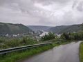
not so golden bridge in the rain
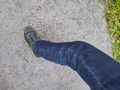
wet legs
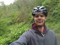
StupidGrinTM
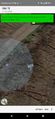
proof


Achievements
Gefrierbrand earned the Land geohash achievement
|
Gefrierbrand earned the Bicycle geohash achievement
|
Gefrierbrand earned the Drowned Rat Geohash Achievement
|