Difference between revisions of "2023-05-15 55 -3"
(start to fill out) |
m (Location) |
||
| (4 intermediate revisions by one other user not shown) | |||
| Line 1: | Line 1: | ||
| − | [[Image:{{{image|2023-05-15 55 -3 seen from about 200m away.jpeg}}}|thumb|left]] | + | [[Image:{{{image|2023-05-15 55 -3 seen from about 200m away.jpeg}}}|thumb|left|The geohash is somewhere behind the second fence, in the field with the cows.]] |
{{meetup graticule | {{meetup graticule | ||
| Line 20: | Line 20: | ||
== Expedition == | == Expedition == | ||
| − | After a [ | + | After a [https://queer.party/@Gaelan/110372723791680014 rather underwhelming] bus journey across the Forth and breakfast in the nearby Costa with some fellow nerds I met on the bus, I head across the street to Edinburgh Park railway station. Immediately yikes: I just caught the very first AB1, so it's before 9:30am, and neither off-peak tickets nor my railcard are any good. One eye-watering fare later, I'm on the train (a lovely class 385), which stops at Linlithgow, then Polmont, where I get off. There's a sign here advertising the Grand Union Canal footpath, with a 2.5 hour walking time back to Linlithgow - tempting, I wonder if I'll have time for that on the way back! |
Head out of the station and onto a small high street - 4 or 5 shops, several of which look to be permanently closed. The bus stop's just across the road, and the "1" bus arrives about 5 minutes behind schedule to take me to Maddiston, another small village with some shops - about a 10-minute ride. From there, it's about a 20-minute walk along some B roads (with a sidewalk! perhaps to be expected here, but the American in me is pleasantly surprised) to our destination, a settlement called, according to various signs, Muiravonside or The Loan. It's a row of houses along a road. | Head out of the station and onto a small high street - 4 or 5 shops, several of which look to be permanently closed. The bus stop's just across the road, and the "1" bus arrives about 5 minutes behind schedule to take me to Maddiston, another small village with some shops - about a 10-minute ride. From there, it's about a 20-minute walk along some B roads (with a sidewalk! perhaps to be expected here, but the American in me is pleasantly surprised) to our destination, a settlement called, according to various signs, Muiravonside or The Loan. It's a row of houses along a road. | ||
| Line 28: | Line 28: | ||
I walked the length of Muiravonside a coupe times looking for another way through; eventually I settled for another road, also gated, but this one marked as a possible footpath on the Ramblers Scotland map. I hopped the gate and headed down a bit, before realizing that there were now several fences between me and the field I needed to be in, and in any case the field I needed to be in was full of cows that I suspect are best left alone. At least I could get a photo of the point from here. So oh well, this one's not really reachable—the closest I got was the first gate, ~180m away. | I walked the length of Muiravonside a coupe times looking for another way through; eventually I settled for another road, also gated, but this one marked as a possible footpath on the Ramblers Scotland map. I hopped the gate and headed down a bit, before realizing that there were now several fences between me and the field I needed to be in, and in any case the field I needed to be in was full of cows that I suspect are best left alone. At least I could get a photo of the point from here. So oh well, this one's not really reachable—the closest I got was the first gate, ~180m away. | ||
| − | At some point over the course of all this looking around, I noticed a sign for a public footpath from The Loan to, among other places, the Union Canal. Recalling the sign from back at Polmont, I decided to take the footpath and see if it would become a scenic route back to a station - and boy did it! After a nice initial wooded section, I joined the path along the Union Canal. That path took me through some lovely countryside, over | + | At some point over the course of all this looking around, I noticed a sign for a public footpath from The Loan to, among other places, the Union Canal. Recalling the sign from back at Polmont, I decided to take the footpath and see if it would become a scenic route back to a station - and boy did it! After a nice initial wooded section, I joined the path along the Union Canal. That path took me through some lovely countryside, over the gorgeous 1800s Avon Aqueduct, and ultimately to Linlithgow station, from which I get a train home. |
So on paper it's a failure, but nevertheless a tour around a gorgeous bit of obscure Central Belt countryside, so I'm certainly not complaining. | So on paper it's a failure, but nevertheless a tour around a gorgeous bit of obscure Central Belt countryside, so I'm certainly not complaining. | ||
| Line 35: | Line 35: | ||
<!-- if your GPS device keeps a log, you may use Template:Tracklog, post a link here, or both --> | <!-- if your GPS device keeps a log, you may use Template:Tracklog, post a link here, or both --> | ||
| − | == Photos == | + | == Photos == |
| − | |||
| − | |||
| − | |||
<gallery perrow="5"> | <gallery perrow="5"> | ||
| + | Image:2023-05-15 55 -3 b.jpeg | The B805 out of Maddiston. Lovely day for a geohash! | ||
| + | Image:2023-05-15 55 -3 a.jpeg | A lovely wooded footpath on the way back from The Loan. | ||
| + | Image:2023-05-15 55 -3 e.jpeg | A swan chilling by the canal. | ||
| + | Image:2023-05-15 55 -3 c.jpeg | The Avon Viaduct. | ||
| + | Image:2023-05-15 55 -3 d.jpeg | The view from atop the viaduct. | ||
</gallery> | </gallery> | ||
| − | |||
| − | |||
| − | |||
| − | |||
__NOTOC__ | __NOTOC__ | ||
| − | |||
| − | |||
| − | |||
| − | |||
| − | |||
| − | |||
| − | |||
| − | |||
| − | |||
| − | |||
| − | |||
| − | |||
| − | |||
| − | |||
[[Category:Expeditions]] | [[Category:Expeditions]] | ||
| − | |||
[[Category:Expeditions with photos]] | [[Category:Expeditions with photos]] | ||
| − | |||
[[Category:Expedition without GPS]] | [[Category:Expedition without GPS]] | ||
| − | |||
| − | |||
| − | |||
| − | |||
| − | |||
| − | |||
[[Category:Coordinates not reached]] | [[Category:Coordinates not reached]] | ||
| − | |||
| − | |||
| − | |||
| − | |||
| − | |||
[[Category:Not reached - No public access]] | [[Category:Not reached - No public access]] | ||
| − | + | {{location|GB|SCT|FAL}} | |
| − | |||
| − | |||
| − | |||
| − | |||
| − | |||
| − | |||
| − | |||
Latest revision as of 15:42, 15 May 2023

| Mon 15 May 2023 in 55,-3: 55.9612918, -3.6801606 geohashing.info google osm bing/os kml crox |
Location
Out in a field behind some houses in rural Falkirk, about an hour (by foot or part of the way with a bus) from Polmont station. From satellite view, looks like there's a gap between the hoses with a path I can use to get into the field.
Participants
Plans
I was heading down south of the Forth anyway for unrelated, yet equally nerdy reasons (checking out Stagecoach's new "autonomous" AB1 bus service across the Forth Road Bridge from Ferrytoll to Edinburgh Park); the night before, I was somehow reminded of this "geohashing" thing, and lo and behold, the Falkirk location isn't too far from Edinburgh Park by train. Let's give it a shot, shall we?
Expedition
After a rather underwhelming bus journey across the Forth and breakfast in the nearby Costa with some fellow nerds I met on the bus, I head across the street to Edinburgh Park railway station. Immediately yikes: I just caught the very first AB1, so it's before 9:30am, and neither off-peak tickets nor my railcard are any good. One eye-watering fare later, I'm on the train (a lovely class 385), which stops at Linlithgow, then Polmont, where I get off. There's a sign here advertising the Grand Union Canal footpath, with a 2.5 hour walking time back to Linlithgow - tempting, I wonder if I'll have time for that on the way back!
Head out of the station and onto a small high street - 4 or 5 shops, several of which look to be permanently closed. The bus stop's just across the road, and the "1" bus arrives about 5 minutes behind schedule to take me to Maddiston, another small village with some shops - about a 10-minute ride. From there, it's about a 20-minute walk along some B roads (with a sidewalk! perhaps to be expected here, but the American in me is pleasantly surprised) to our destination, a settlement called, according to various signs, Muiravonside or The Loan. It's a row of houses along a road.
It's at this point that I realize the dirt road behind the houses to the fields is in fact gated, and goes right by a house beyond the gate; while I could have hopped the gate, and it might even have been legal to do so in Scotland, I think it's something of a borderline case and I wasn't particularly in the mood to explain geohashing to an angry farmer.
I walked the length of Muiravonside a coupe times looking for another way through; eventually I settled for another road, also gated, but this one marked as a possible footpath on the Ramblers Scotland map. I hopped the gate and headed down a bit, before realizing that there were now several fences between me and the field I needed to be in, and in any case the field I needed to be in was full of cows that I suspect are best left alone. At least I could get a photo of the point from here. So oh well, this one's not really reachable—the closest I got was the first gate, ~180m away.
At some point over the course of all this looking around, I noticed a sign for a public footpath from The Loan to, among other places, the Union Canal. Recalling the sign from back at Polmont, I decided to take the footpath and see if it would become a scenic route back to a station - and boy did it! After a nice initial wooded section, I joined the path along the Union Canal. That path took me through some lovely countryside, over the gorgeous 1800s Avon Aqueduct, and ultimately to Linlithgow station, from which I get a train home.
So on paper it's a failure, but nevertheless a tour around a gorgeous bit of obscure Central Belt countryside, so I'm certainly not complaining.
Tracklog
Photos
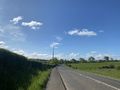
The B805 out of Maddiston. Lovely day for a geohash!
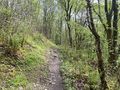
A lovely wooded footpath on the way back from The Loan.
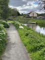
A swan chilling by the canal.
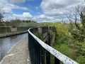
The Avon Viaduct.
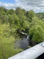
The view from atop the viaduct.


