Difference between revisions of "2023-05-18 48 7"
(Add photos) |
(Coordinates reached) |
||
| Line 12: | Line 12: | ||
== Plans == | == Plans == | ||
[[User:Baarde|Baarde]] will cycle there in the morning. He expects to arrive at 09:25. | [[User:Baarde|Baarde]] will cycle there in the morning. He expects to arrive at 09:25. | ||
| + | |||
| + | == Expedition == | ||
| + | I cycled from Sélestat to Bergheim, then through the village up to the vineyards. | ||
| + | |||
| + | The coordinates were located on a hill named ''Le Grasberg''. From there I add a nice view on the [[2023-04-12 48 7|Chateau du Haut-Koenisbourg]] to the North, the Château de Reichenberg to the West, and the French and German flags that fly above the German war cemetery on the top of the hill to the East. Unfortunately, I didn't have time to visit any of those. | ||
| + | |||
| + | After recording proof, I cycled back home, took a shower, then went to my mother's for lunch. | ||
== Photos == | == Photos == | ||
| Line 24: | Line 31: | ||
File:2023-05-18 48 7 08.jpg | Stupid grin | File:2023-05-18 48 7 08.jpg | Stupid grin | ||
</gallery> | </gallery> | ||
| + | |||
| + | == Achievements == | ||
| + | {{#vardefine:ribbonwidth|100%}} | ||
| + | {{land geohash | ||
| + | | latitude = 48 | ||
| + | | longitude = 7 | ||
| + | | date = 2023-05-18 | ||
| + | | name = [[User:Baarde|Baarde]] | ||
| + | }} | ||
| + | {{bicycle geohash | ||
| + | | latitude = 48 | ||
| + | | longitude = 7 | ||
| + | | date = 2023-05-18 | ||
| + | | name = [[User:Baarde|Baarde]] | ||
| + | | distance = 24 km | ||
| + | | bothways = true | ||
| + | }} | ||
__NOTOC__ | __NOTOC__ | ||
[[Category:Expeditions]] | [[Category:Expeditions]] | ||
[[Category:Expeditions with photos]] | [[Category:Expeditions with photos]] | ||
| + | [[Category:Coordinates reached]] | ||
{{location|FR|68}} | {{location|FR|68}} | ||
Latest revision as of 18:22, 20 May 2023
| Thu 18 May 2023 in 48,7: 48.2135071, 7.3504408 geohashing.info google osm bing/os kml crox |
Location
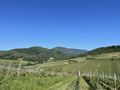
In the vineyards in Bergheim.
Participants
Plans
Baarde will cycle there in the morning. He expects to arrive at 09:25.
Expedition
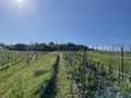
I cycled from Sélestat to Bergheim, then through the village up to the vineyards.
The coordinates were located on a hill named Le Grasberg. From there I add a nice view on the Chateau du Haut-Koenisbourg to the North, the Château de Reichenberg to the West, and the French and German flags that fly above the German war cemetery on the top of the hill to the East. Unfortunately, I didn't have time to visit any of those.
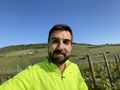
After recording proof, I cycled back home, took a shower, then went to my mother's for lunch.
Photos
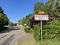
In Bergheim
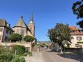
Cycling through Bergheim
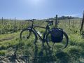
My bicycle below the geohash
Coordinates reached
Surroundings (West)

Surroundings (North)
Surroundings (East)
Stupid grin


Achievements
Baarde earned the Land geohash achievement
|
Baarde earned the Bicycle geohash achievement
|