Difference between revisions of "2023-05-20 50 8"
(An expedition message sent via Geohash Droid for Android.) |
|||
| (13 intermediate revisions by the same user not shown) | |||
| Line 1: | Line 1: | ||
| − | + | {{meetup graticule | |
| − | |||
| − | |||
| − | |||
| − | |||
| − | |||
| − | |||
| − | |||
| − | |||
| lat=50 | | lat=50 | ||
| lon=8 | | lon=8 | ||
| date=2023-05-20 | | date=2023-05-20 | ||
| − | }} | + | | graticule_name=Frankfurt am Main |
| + | | graticule_link=Frankfurt am Main, Germany}} | ||
| + | |||
== Location == | == Location == | ||
| − | + | In the forest close to the Naturfreundehaus Billtalhöhe. | |
== Participants == | == Participants == | ||
| − | + | * [[User:Monotof|Monotof]] | |
| − | |||
== Plans == | == Plans == | ||
| − | + | The hash point was near a path in a nearby forest, and the sunny Saturday beckoned me outside. | |
== Expedition == | == Expedition == | ||
| − | + | ==== To the hash point ==== | |
| + | I took my bike and rode to the local train station. From there, I transferred to a bus after three stops to reach the quaint town of Königstein (im Taunus). On the bus, I noticed some passengers wearing beautiful medieval robes. It turned out there was a medieval fair in the castle ruins of Königsstein this weekend. However, without proper attire and with my bike, I didn't enter the fair. | ||
| − | + | From the beautiful old town center, I followed the Woogbach around the hill whereon the castle ruins sit, enjoying the amazing scenery along the way. After crossing the Rombach, the path became more intense, with a 200m climb without respite until I reached the hash point. | |
| − | |||
| − | == | + | ==== At the hash point ==== |
| − | + | The hash point was in the forest about 20m off the path. It was relatively easy to reach since it was dry and had minimal underbrush. However, the exact hash point was in the middle of some bushes and small trees. Nevertheless, I managed to locate it accurately. Even though it was just a random spot in the forest like many others, it was still very pleasant, with soft moss under my feet, the sun shining through the leaves, and birds chirping in the wind. | |
| − | |||
| − | |||
| − | |||
| − | |||
| − | + | I arrived early at 15:33, so after taking the prerequisite pictures, I enjoyed a well-deserved afternoon lunch break. Since no other hash point hunters showed up by 16:10, I got back on my bike to make the longer but mostly downhill trip back to Oberursel, where I originally transferred from the train to the bus. | |
| − | |||
| − | |||
| − | + | ==== Back home ==== | |
| − | + | Riding past the Naturfreundehaus Billtalhöhe, I reached the B8 (Limburger Straße), which was exciting because of its super smooth asphalt and steep downhill section, allowing for high speeds. However, it was a busy "highway" without any separated bike lanes, therefore also a bit scary. Fortunately, I only needed to ride on it for 1.2 km, which flew by at quite high speeds. Once I got back onto forest paths, I rode up small final climb into Falkenstein. | |
| − | |||
| − | |||
| − | + | A significant portion of this entire region is quite wealthy, and Falkenstein boasts some incredibly beautiful houses. It is a prime location next to the forest, on top of the hill, offering great views. | |
| − | + | I followed the Arbeiterweg out of Falkenstein, which turned into the Kaiserin-Friedrich-Weg and, finally, the Altkönigweg. At the last crossing, near the Emminghaushütte, I realized my major blunder with this trip: The superb Flowtrail Bad-Endbach started there (and even went in the right direction), but I was on my regular city/touring bike, not my mountain bike. | |
| − | + | Unfortunately, I didn't realize I would come across the Flowtrail on this trip, so I didn't think to bring the mountain bike. Therefore, I had to skip it and ride straight to my destination of Oberursel. With a few minutes to spare before catching my train, I explored the historic town center of Oberursel, which was very nice and definitely worth another expedition. | |
| − | |||
| − | |||
| − | + | Overall, the nearly 14 km ride back was pure bliss because it was mostly downhill the entire way. I definitely made the right call in that regard. | |
| − | < | + | == Photos == |
| + | <gallery> | ||
| + | Image:2023-05-20 50 8 145340.jpg|Serene scenery at the Woogbach | ||
| + | Image:2023-05-20 50 8 145349.jpg|More picturesque scenery | ||
| + | Image:2023-05-20 50 8 150252.jpg|Castle ruins with ongoing medival fair | ||
| + | Image:2023-05-20 50 8 150520.jpg|View over Königstein | ||
| + | Image:2023-05-20 50 8 153314 Geohash Droid.jpg|Within 1m of the hash point | ||
| + | Image:2023-05-20 50 8 153440.jpg|Stupid Grin | ||
| + | Image:2023-05-20 50 8 153607.jpg|View of the hash point, its pretty much in the center of the image | ||
| + | Image:2023-05-20 50 8 154935.jpg|Panorama from in front of the hash point | ||
| + | Image:2023-05-20 50 8 161946.jpg|Nice house in Falkenstein | ||
| + | </gallery> | ||
| + | |||
| + | __NOTOC__ | ||
[[Category:Expeditions]] | [[Category:Expeditions]] | ||
| − | |||
[[Category:Expeditions with photos]] | [[Category:Expeditions with photos]] | ||
| − | |||
| − | |||
| − | |||
| − | |||
| − | |||
[[Category:Coordinates reached]] | [[Category:Coordinates reached]] | ||
| − | + | {{location|DE|HE|HG}} | |
| − | |||
| − | |||
| − | |||
| − | |||
| − | |||
| − | |||
| − | |||
| − | |||
| − | |||
| − | |||
| − | |||
| − | |||
| − | |||
| − | |||
| − | |||
| − | |||
| − | |||
Latest revision as of 19:39, 20 May 2023
| Sat 20 May 2023 in Frankfurt am Main: 50.1961006, 8.4381411 geohashing.info google osm bing/os kml crox |
Location
In the forest close to the Naturfreundehaus Billtalhöhe.
Participants
Plans
The hash point was near a path in a nearby forest, and the sunny Saturday beckoned me outside.
Expedition
To the hash point
I took my bike and rode to the local train station. From there, I transferred to a bus after three stops to reach the quaint town of Königstein (im Taunus). On the bus, I noticed some passengers wearing beautiful medieval robes. It turned out there was a medieval fair in the castle ruins of Königsstein this weekend. However, without proper attire and with my bike, I didn't enter the fair.
From the beautiful old town center, I followed the Woogbach around the hill whereon the castle ruins sit, enjoying the amazing scenery along the way. After crossing the Rombach, the path became more intense, with a 200m climb without respite until I reached the hash point.
At the hash point
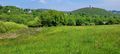
The hash point was in the forest about 20m off the path. It was relatively easy to reach since it was dry and had minimal underbrush. However, the exact hash point was in the middle of some bushes and small trees. Nevertheless, I managed to locate it accurately. Even though it was just a random spot in the forest like many others, it was still very pleasant, with soft moss under my feet, the sun shining through the leaves, and birds chirping in the wind.
I arrived early at 15:33, so after taking the prerequisite pictures, I enjoyed a well-deserved afternoon lunch break. Since no other hash point hunters showed up by 16:10, I got back on my bike to make the longer but mostly downhill trip back to Oberursel, where I originally transferred from the train to the bus.
Back home
Riding past the Naturfreundehaus Billtalhöhe, I reached the B8 (Limburger Straße), which was exciting because of its super smooth asphalt and steep downhill section, allowing for high speeds. However, it was a busy "highway" without any separated bike lanes, therefore also a bit scary. Fortunately, I only needed to ride on it for 1.2 km, which flew by at quite high speeds. Once I got back onto forest paths, I rode up small final climb into Falkenstein.
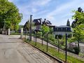
A significant portion of this entire region is quite wealthy, and Falkenstein boasts some incredibly beautiful houses. It is a prime location next to the forest, on top of the hill, offering great views.
I followed the Arbeiterweg out of Falkenstein, which turned into the Kaiserin-Friedrich-Weg and, finally, the Altkönigweg. At the last crossing, near the Emminghaushütte, I realized my major blunder with this trip: The superb Flowtrail Bad-Endbach started there (and even went in the right direction), but I was on my regular city/touring bike, not my mountain bike. Unfortunately, I didn't realize I would come across the Flowtrail on this trip, so I didn't think to bring the mountain bike. Therefore, I had to skip it and ride straight to my destination of Oberursel. With a few minutes to spare before catching my train, I explored the historic town center of Oberursel, which was very nice and definitely worth another expedition.
Overall, the nearly 14 km ride back was pure bliss because it was mostly downhill the entire way. I definitely made the right call in that regard.
Photos
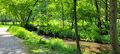
Serene scenery at the Woogbach
More picturesque scenery
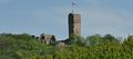
Castle ruins with ongoing medival fair
View over Königstein

Within 1m of the hash point

Stupid Grin
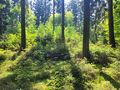
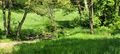
View of the hash point, its pretty much in the center of the image
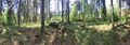
Panorama from in front of the hash point
Nice house in Falkenstein


