Difference between revisions of "2023-05-21 43 -79"
([live picture]Horseys at the spinny condos!) |
m |
||
| (3 intermediate revisions by 2 users not shown) | |||
| Line 1: | Line 1: | ||
| − | + | [[Image:{{{image|2023-05-21 43 -79 frogman 1684710857237.jpg}}}|thumb|left]] | |
| − | + | {{meetup graticule | |
| − | |||
| − | |||
| − | |||
| − | |||
| − | |||
| − | |||
| lat=43 | | lat=43 | ||
| lon=-79 | | lon=-79 | ||
| Line 13: | Line 7: | ||
}}<!-- edit as necessary --> | }}<!-- edit as necessary --> | ||
== Location == | == Location == | ||
| − | + | On the grounds of Metropolitan Andrei Catholic School in Mississauga. | |
== Participants == | == Participants == | ||
| − | + | *[[User:Frogman|Frogman]] | |
| − | |||
| − | |||
| − | |||
| − | |||
== Expedition == | == Expedition == | ||
| − | + | Lovely day for some geohashing! I took the subway to Kipling and then the MiWay (Mississauga transit) bus to the hashpoint. The transfer from the subway to the bus was underground, but my transit app was confused, so I ended up getting lost and walking up to street level and over to the other entrance building. It was my first time in the MiWay/GO terminal at Kipling, which is recently-constructed. It's a nice building, with some pretty murals! | |
| − | + | The bus ride was pretty smooth and dropped me off directly in front of the school where the hashpoint was. After standing by a brick wall and snapping a couple photos, I took the opportunity to explore this part of Mississauga. I took a walk through a really nice series of parks and footpaths. A lot of people were out on this gorgeous day! One of the paths I took follows Cooksville Creek, a small river which eventually drains into Lake Ontario. I went the other direction, though, and arrived at downtown Mississauga, a densely-populated area that would probably be quite nice except for the absolutely horrible pedestrian experience. I had planned on maybe spending some time here, but I saw that my infrequent bus home was showing up soon, so I took that instead. | |
| − | |||
== Photos == | == Photos == | ||
| − | |||
| − | |||
| − | |||
<gallery perrow="5"> | <gallery perrow="5"> | ||
| Line 59: | Line 45: | ||
Image:2023-05-21_43_-79_frogman_1684711020702.jpg|Horseys at the spinny condos! | Image:2023-05-21_43_-79_frogman_1684711020702.jpg|Horseys at the spinny condos! | ||
| + | |||
| + | Image:2023-05-21_43_-79_frogman_1684711036884.jpg|Some groovy bus seat patterns | ||
</gallery> | </gallery> | ||
== Achievements == | == Achievements == | ||
{{#vardefine:ribbonwidth|100%}} | {{#vardefine:ribbonwidth|100%}} | ||
| − | + | {{Public transport geohash | |
| − | + | | latitude = 43 | |
| − | + | | longitude = -79 | |
| − | + | | date = 2023-05-21 | |
| − | [[ | + | | busline = the TTC and MiWay |
| + | | name = [[User:Frogman|Frogman]] | ||
| + | | image = 2023-05-21 43 -79 frogman 1684710790524.jpg | ||
| + | |||
| + | }} | ||
| − | + | {{Geohashing Day | |
| − | + | | latitude = 43 | |
| − | + | | longitude = -79 | |
| − | [[ | + | | year = 2023 |
| − | + | | coorddate= 2023-05-21 | |
| + | | name = [[User:Frogman|Frogman]] | ||
| − | + | }} | |
| − | <!-- | + | __NOTOC__ |
| + | <!-- =============== USEFUL CATEGORIES FOLLOW ================--> | ||
[[Category:Expeditions]] | [[Category:Expeditions]] | ||
| − | |||
[[Category:Expeditions with photos]] | [[Category:Expeditions with photos]] | ||
| − | |||
| − | |||
| − | |||
| − | |||
| − | |||
[[Category:Coordinates reached]] | [[Category:Coordinates reached]] | ||
| − | + | {{location|CA|ON|PL}} | |
| − | |||
| − | |||
| − | |||
| − | |||
| − | |||
| − | |||
| − | |||
| − | |||
| − | |||
| − | |||
| − | |||
| − | |||
| − | |||
| − | |||
| − | |||
| − | |||
| − | |||
Latest revision as of 20:23, 24 May 2023

| Sun 21 May 2023 in 43,-79: 43.5922794, -79.6138417 geohashing.info google osm bing/os kml crox |
Location
On the grounds of Metropolitan Andrei Catholic School in Mississauga.
Participants
Expedition
Lovely day for some geohashing! I took the subway to Kipling and then the MiWay (Mississauga transit) bus to the hashpoint. The transfer from the subway to the bus was underground, but my transit app was confused, so I ended up getting lost and walking up to street level and over to the other entrance building. It was my first time in the MiWay/GO terminal at Kipling, which is recently-constructed. It's a nice building, with some pretty murals!
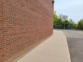
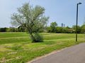
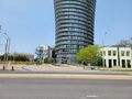
The bus ride was pretty smooth and dropped me off directly in front of the school where the hashpoint was. After standing by a brick wall and snapping a couple photos, I took the opportunity to explore this part of Mississauga. I took a walk through a really nice series of parks and footpaths. A lot of people were out on this gorgeous day! One of the paths I took follows Cooksville Creek, a small river which eventually drains into Lake Ontario. I went the other direction, though, and arrived at downtown Mississauga, a densely-populated area that would probably be quite nice except for the absolutely horrible pedestrian experience. I had planned on maybe spending some time here, but I saw that my infrequent bus home was showing up soon, so I took that instead.
Photos
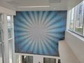
Mural at Kipling Station.
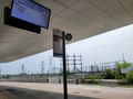
Waiting for the bus.
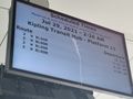
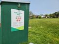
The sign seems a little confused...
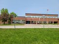
Metropolitan Andrei Catholic School.
At the hashpoint!
The hashpoint is here.

Me!
Walking to downtown Mississauga
Anyone for some ice skating?
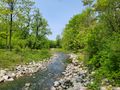
Cooksville Creek, north
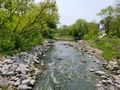
Cooksville Creek, south
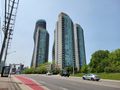
The view upon exiting the creek trail
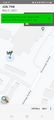
Horseys at the spinny condos!
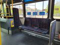
Some groovy bus seat patterns


Achievements
Frogman earned the Public transport geohash achievement
|
Frogman earned the 2023 Geohashing Day achievement
|