Difference between revisions of "2023-05-24 42 -71"
From Geohashing
([live picture]Context. [https://openstreetmap.org/?mlat=42.36712687&mlon=-71.07565091&zoom=16 @42.3671,-71.0757]) |
(Categories) |
||
| Line 14: | Line 14: | ||
== Location == | == Location == | ||
<!-- where you've surveyed the hash to be --> | <!-- where you've surveyed the hash to be --> | ||
| + | This Geohash is located on Land Boulevard in Cambridge. | ||
== Participants == | == Participants == | ||
<!-- who attended: If you link to your wiki user name in this section, your expedition will be picked up by the various statistics generated for geohashing. You may use three tildes ~ as a shortcut to automatically insert the user signature of the account you are editing with. | <!-- who attended: If you link to your wiki user name in this section, your expedition will be picked up by the various statistics generated for geohashing. You may use three tildes ~ as a shortcut to automatically insert the user signature of the account you are editing with. | ||
--> | --> | ||
| + | *[[User:JesseFTW|JesseFTW]] | ||
== Plans == | == Plans == | ||
<!-- what were the original plans --> | <!-- what were the original plans --> | ||
| + | *This is an easy walk, so I'm going to drop by soon. -- [[User:JesseFTW|JesseFTW]] ([[User talk:JesseFTW|talk]]) [https://openstreetmap.org/?mlat=42.36365390&mlon=-71.08304080&zoom=16 @42.3637,-71.0830] 17:04, 24 May 2023 (EDT) | ||
== Expedition == | == Expedition == | ||
<!-- how it all turned out. your narrative goes here. --> | <!-- how it all turned out. your narrative goes here. --> | ||
| − | |||
| − | |||
| − | |||
| − | |||
| − | |||
== Photos == | == Photos == | ||
| Line 46: | Line 44: | ||
__NOTOC__ | __NOTOC__ | ||
| − | |||
| − | |||
| − | |||
| − | |||
| − | |||
| − | |||
| − | |||
| − | |||
| − | |||
| − | |||
| − | |||
| − | |||
| − | |||
| − | |||
[[Category:Expeditions]] | [[Category:Expeditions]] | ||
| − | |||
[[Category:Expeditions with photos]] | [[Category:Expeditions with photos]] | ||
| − | |||
| − | |||
| − | |||
| − | |||
| − | |||
[[Category:Coordinates reached]] | [[Category:Coordinates reached]] | ||
| − | |||
| − | |||
| − | |||
| − | |||
| − | |||
| − | |||
| − | |||
| − | |||
| − | |||
| − | |||
| − | |||
| − | |||
| − | |||
| − | |||
| − | |||
| − | |||
| − | |||
| − | |||
Revision as of 20:15, 7 July 2023
| Wed 24 May 2023 in 42,-71: 42.3671040, -71.0753633 geohashing.info google osm bing/os kml crox |
Location
This Geohash is located on Land Boulevard in Cambridge.
Participants
Plans
- This is an easy walk, so I'm going to drop by soon. -- JesseFTW (talk) @42.3637,-71.0830 17:04, 24 May 2023 (EDT)
Expedition
Photos
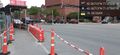
And arrived!
Context. @42.3671,-71.0757

