Difference between revisions of "2023-06-18 39 -112"
(Plans as proof for radio yerivan easy geohash achievement) |
(add photos) |
||
| Line 1: | Line 1: | ||
| − | + | [[Image:2023-06-18 39 -112 Spot.jpg|thumb|left]] | |
| − | + | {{meetup graticule | |
| − | [[Image: | ||
| − | |||
| − | |||
| − | |||
| − | |||
| − | |||
| − | |||
| lat=39 | | lat=39 | ||
| lon=-112 | | lon=-112 | ||
| date=2023-06-18 | | date=2023-06-18 | ||
| − | }} | + | }} |
== Location == | == Location == | ||
| − | |||
Just off of Highway 6, South of Eureka. | Just off of Highway 6, South of Eureka. | ||
| Line 23: | Line 15: | ||
== Expedition == | == Expedition == | ||
| − | As we were driving by, we realized there wasn't a shoulder. It didn't seem safe to stop and get this hash. But, about a quarter mile past the spot, there was a turn off for a road. We parked there, and I walked the 3 minutes back to the hash. Population: Tire | + | As we were driving by, we realized there wasn't a shoulder. It didn't seem safe to stop and get this hash. But, about a quarter mile past the spot, there was a turn off for a road. We parked there, and I walked the 3 minutes back to the hash. [http://hrwiki.org/wiki/Tire Population: Tire] |
== Photos == | == Photos == | ||
Forthcoming | Forthcoming | ||
| − | |||
| − | |||
| − | |||
<gallery perrow="5"> | <gallery perrow="5"> | ||
| + | Image:2023-06-18 39 -112 Grin.jpg | Grin | ||
| + | Image:2023-06-18 39 -112 Spot.jpg | Spot. [http://hrwiki.org/wiki/Tire Population Tire] | ||
| + | Image:2023-06-18 39 -112 GPS.png | GPS | ||
</gallery> | </gallery> | ||
| Line 39: | Line 31: | ||
__NOTOC__ | __NOTOC__ | ||
| − | |||
| − | |||
| − | |||
| − | |||
| − | |||
| − | |||
| − | |||
| − | |||
| − | |||
| − | |||
| − | |||
| − | |||
| − | |||
| − | |||
| − | |||
| − | |||
[[Category:Expeditions with photos]] | [[Category:Expeditions with photos]] | ||
| − | |||
| − | |||
| − | |||
| − | |||
| − | |||
[[Category:Coordinates reached]] | [[Category:Coordinates reached]] | ||
| − | |||
| − | |||
| − | |||
| − | |||
| − | |||
| − | |||
| − | |||
| − | |||
| − | |||
| − | |||
| − | |||
| − | |||
| − | |||
| − | |||
| − | |||
| − | |||
| − | |||
| − | |||
Revision as of 04:42, 18 June 2023

| Sun 18 Jun 2023 in 39,-112: 39.8986628, -112.1376873 geohashing.info google osm bing/os kml crox |
Location
Just off of Highway 6, South of Eureka.
Participants
Plans
Coincidentally, we had an event in Sandy Utah, followed by another event in Delta Utah. Given that we live east of Utah lake, when we were planning this trip over a week ago, we decided we would travel west of the lake to get to Delta. It's a more beautiful drive, and it uses less energy for our car. So just driving down that road, would have put us within moving GPS tolerance of the hash. Easy geohash achievement right? Stop by, grab some proof, keep going. However, The plan to drive past the spot is for today, and this is the hash for tomorrow. So technically I'm doing a hash in the future. That's deja vu achievement right?
Expedition
As we were driving by, we realized there wasn't a shoulder. It didn't seem safe to stop and get this hash. But, about a quarter mile past the spot, there was a turn off for a road. We parked there, and I walked the 3 minutes back to the hash. Population: Tire
Photos
Forthcoming
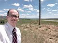
Grin
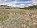
Spot. Population Tire
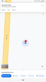
GPS


Achievements
Is it true that McKay (talk) earned the achievement = Déjà-vu geohash achievement?
|
Is it true that McKay (talk) earned the achievement = Easy geohash achievement?
|