Difference between revisions of "2023-06-20 32 34"
Yerushalmi (talk | contribs) (Created page with "{{subst:Expedition |lat = 32 |lon = 34 |date = 2023-06-20 }}") |
Yerushalmi (talk | contribs) |
||
| Line 13: | Line 13: | ||
}}<!-- edit as necessary --> | }}<!-- edit as necessary --> | ||
== Location == | == Location == | ||
| − | + | Barely a couple dozen meters off of an established nature trail called Shvil Ramot Menashe. | |
== Participants == | == Participants == | ||
| − | + | [[User:Yerushalmi|Yerushalmi]] ([[User talk:Yerushalmi|talk]]) | |
| − | |||
== Plans == | == Plans == | ||
| − | + | Take public transportation to Moshav Ofer, then walk down Shvil Ramot Menashe to Kibbutz Bat Shlomo. | |
== Expedition == | == Expedition == | ||
| − | + | Other than getting severely carsick on the last leg of the journey (which consisted of a bus ride that brings you to every single town and village between the Binyamina rail station and Hof Hacarmel - which involves many many many traffic circles), the trip to Moshav Ofer went exactly as intended. | |
| − | + | Leaving Moshav Ofer involved making a choice: Do I go straight south from the bus stop and hope that the southern gate of the moshav is open, or do I head north and around, which takes a lot longer? Well, I had plenty of time to try both, so I went straight south - and the gate was open. | |
| − | |||
| − | + | From there it was simply a matter of finding the start of the nature trail, which was marked with a red stripe... | |
| − | + | ||
| − | + | [[File:20230620_112837.jpg|400px]] | |
| − | + | ||
| − | + | Then you get to the point on the trail that's parallel to the point... | |
| − | |||
| − | + | [[File:Screenshot_20230620_113703_Geohash Droid.jpg|400px]] | |
| − | |||
| − | |||
| − | + | Turn left to leave the trail... | |
| − | |||
| − | |||
| − | |||
| − | + | [[File:20230620_113711.jpg|400px]] | |
| − | + | Goddammit! | |
| − | |||
| − | |||
| − | |||
| − | + | Well, nothing for it. I'll keep walking and maybe I'll get lucky and find out who owns the fenced-off area and ask them for permission... | |
| − | + | [[File:20230620_113750.jpg|400px]] | |
| − | |||
| − | |||
| − | |||
| − | |||
| − | |||
| − | |||
| − | |||
| − | |||
| − | [[ | ||
| + | Or maybe I'll get even luckier and it turns out the nature trail actually enters the fenced-off area itself. Turns out - and there were a few clues to this on Amud Anan, but I didn't realize what they actually meant until now - that the fenced-off area is just a convenient (and extremely large) plot of land that the nearby towns use for grazing cattle, and is not actually owned by anybody. The fence is there just to keep the cattle from escaping. So reaching the point turned out to be pretty easy - I was only five minutes off the trail and back on. | ||
| − | + | From there it was a pleasant walk to Kibbutz Bat Shlomo, an hour wait for a bus, and then the trip home. | |
| − | |||
| − | |||
| − | |||
| − | |||
| − | |||
| − | |||
| − | |||
| − | + | == Photos == | |
| − | + | <gallery perrow="5"> | |
| − | + | File:20230620_112508.jpg | |
| − | + | File:20230620_112837.jpg | Two nature trail signs, one for bicycles and one for walking. They only rarely diverged. | |
| − | + | File:20230620_113042.jpg | |
| + | File:Screenshot_20230620_113703_Geohash Droid.jpg | Just parallel to the point... | ||
| + | File:20230620_113711.jpg | ...with a barbed wire fence in the way. | ||
| + | File:20230620_113750.jpg | But the barbed wire fence has an open gate marked with the walking trail. | ||
| + | File:20230620_113805.jpg | On the other side of the gate, a sign that says "Please close the gate, thanks". | ||
| + | File:Screenshot_20230620_113953_Geohash Droid.jpg | Proof of success | ||
| + | File:20230620_114004.jpg | Panorama at the point | ||
| + | File:20230620_114205.jpg | Marking xkcd on the ground with dried grass | ||
| + | File:20230620_120537.jpg | The view from up here was beautiful. My photography skills were execrable. | ||
| + | File:20230620_120644.jpg | The exit from the fenced-off part of the nature trail, designed to allow people but not animals through. | ||
| + | File:20230620_120845.jpg | This thing was buzzing ominously. | ||
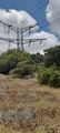
| + | File:20230620_121300.jpg | ||
| + | File:20230620_121303.jpg | ||
| + | </gallery> | ||
| − | + | [[Category:Expeditions]] | |
| + | [[Category:Expeditions with photos]] | ||
| + | [[Category:Coordinates reached]] | ||
Revision as of 08:27, 21 June 2023
| Tue 20 Jun 2023 in 32,34: 32.6104854, 34.9876048 geohashing.info google osm bing/os kml crox |
Contents
Location
Barely a couple dozen meters off of an established nature trail called Shvil Ramot Menashe.
Participants
Plans
Take public transportation to Moshav Ofer, then walk down Shvil Ramot Menashe to Kibbutz Bat Shlomo.
Expedition
Other than getting severely carsick on the last leg of the journey (which consisted of a bus ride that brings you to every single town and village between the Binyamina rail station and Hof Hacarmel - which involves many many many traffic circles), the trip to Moshav Ofer went exactly as intended.
Leaving Moshav Ofer involved making a choice: Do I go straight south from the bus stop and hope that the southern gate of the moshav is open, or do I head north and around, which takes a lot longer? Well, I had plenty of time to try both, so I went straight south - and the gate was open.
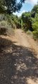
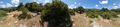
From there it was simply a matter of finding the start of the nature trail, which was marked with a red stripe...

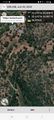
Then you get to the point on the trail that's parallel to the point...

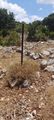
Turn left to leave the trail...

Goddammit!
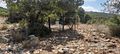
Well, nothing for it. I'll keep walking and maybe I'll get lucky and find out who owns the fenced-off area and ask them for permission...

Or maybe I'll get even luckier and it turns out the nature trail actually enters the fenced-off area itself. Turns out - and there were a few clues to this on Amud Anan, but I didn't realize what they actually meant until now - that the fenced-off area is just a convenient (and extremely large) plot of land that the nearby towns use for grazing cattle, and is not actually owned by anybody. The fence is there just to keep the cattle from escaping. So reaching the point turned out to be pretty easy - I was only five minutes off the trail and back on.
From there it was a pleasant walk to Kibbutz Bat Shlomo, an hour wait for a bus, and then the trip home.
Photos
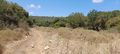
Two nature trail signs, one for bicycles and one for walking. They only rarely diverged.
Just parallel to the point...
...with a barbed wire fence in the way.
But the barbed wire fence has an open gate marked with the walking trail.

On the other side of the gate, a sign that says "Please close the gate, thanks".

Proof of success
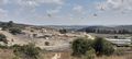
Panorama at the point
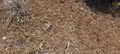
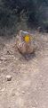
Marking xkcd on the ground with dried grass
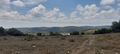
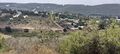
The view from up here was beautiful. My photography skills were execrable.
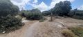
The exit from the fenced-off part of the nature trail, designed to allow people but not animals through.
This thing was buzzing ominously.