Difference between revisions of "2023-06-28 41 -82"
| Line 27: | Line 27: | ||
== Photos == | == Photos == | ||
| − | |||
| − | |||
| − | |||
<gallery perrow="5"> | <gallery perrow="5"> | ||
| Line 48: | Line 45: | ||
__NOTOC__ | __NOTOC__ | ||
| − | |||
| − | |||
| − | |||
| − | |||
| − | |||
| − | |||
| − | |||
| − | |||
| − | |||
| − | |||
| − | |||
| − | |||
| − | |||
| − | |||
[[Category:Expeditions]] | [[Category:Expeditions]] | ||
| − | |||
[[Category:Expeditions with photos]] | [[Category:Expeditions with photos]] | ||
[[Category:Expeditions with videos]] | [[Category:Expeditions with videos]] | ||
[[Category:Expedition without GPS]] | [[Category:Expedition without GPS]] | ||
| − | |||
| − | |||
| − | |||
[[Category:Coordinates reached]] | [[Category:Coordinates reached]] | ||
| − | + | {{location|US|OH|LR}} | |
| − | |||
| − | |||
| − | |||
| − | |||
| − | |||
| − | |||
| − | |||
| − | |||
| − | |||
| − | |||
| − | |||
| − | |||
| − | |||
| − | |||
| − | |||
| − | |||
| − | |||
Revision as of 20:47, 28 June 2023
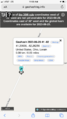
| Wed 28 Jun 2023 in 41,-82: 41.2093552, -82.2625559 geohashing.info google osm bing/os kml crox |
Location
Right off of Quarry Road in Pittsfield Township, Ohio.
Participants
Plans
I was fore-caddying on the fairway of the tenth hole at the Elyria Country Club when I viewed today's hash point. I was excited that it appeared to be actually near a road, instead of inside a field as so many other hashpoints in this graticule have been over the years. Seeing its location, I decided to make the journey once the round was finished. Gratefully, the round took three hours instead of the usual four+, which was well appreciated.
Expedition
Once I finished the round, and after more investigating, I set off of the journey. After following the directions to the point, I pulled into a nicely made clearing about 370 feet past the point. I then set off on my walk to finally claim this graticule. Upon journeying 200 feet, I realized that I had left my makeshift hashcot model train Night Fox in my car, so I ran back to get it. Having securing Nigh Fox, I then ran back to the hashpoint. After confirming it on various websites for insurance, I realized that I had finally done it. My goal for the past four years had been attained, and I was the first to successfully reach a hashpoint in the graticule. It was amazing.
After securing the point, I jogged back to the car, and had to attempt a couple times to leave the area where I was parked, as there was a ditch. I ended up driving straight through the ditch, then I set off on the journey home.
Photos
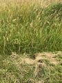
The hashpoint
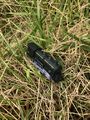
Night Fox at the hashpoint
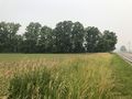
View to the North
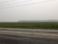
View to the East
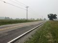
View to the South
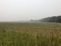
View to the West

Proof
More Proof
Victory


