Difference between revisions of "2023-07-16 40 -74"
([live] I'm here, in the green t-shirt and (vintage) Somerset Patriots cap. Chilling in the parking lot, charging my phone, waiting to see if it will stop raining entirely or not.) |
(→Achievements) |
||
| (6 intermediate revisions by the same user not shown) | |||
| Line 37: | Line 37: | ||
*I'm here, in the green t-shirt and (vintage) Somerset Patriots cap. Chilling in the parking lot, charging my phone, waiting to see if it will stop raining entirely or not. -- [[User:Jevanyn|Jevanyn]] ([[User talk:Jevanyn|talk]]) [https://openstreetmap.org/?mlat=40.55092150&mlon=-74.67095720&zoom=16 @40.5509,-74.6710] 15:33, 16 July 2023 (EDT) | *I'm here, in the green t-shirt and (vintage) Somerset Patriots cap. Chilling in the parking lot, charging my phone, waiting to see if it will stop raining entirely or not. -- [[User:Jevanyn|Jevanyn]] ([[User talk:Jevanyn|talk]]) [https://openstreetmap.org/?mlat=40.55092150&mlon=-74.67095720&zoom=16 @40.5509,-74.6710] 15:33, 16 July 2023 (EDT) | ||
| + | |||
| + | *If your drive all the way down to parking lot D, it's a lot closer to the geohash -- [[User:Jevanyn|Jevanyn]] ([[User talk:Jevanyn|talk]]) [https://openstreetmap.org/?mlat=40.54990090&mlon=-74.67196590&zoom=16 @40.5499,-74.6720] 15:36, 16 July 2023 (EDT) | ||
== Tracklog == | == Tracklog == | ||
<!-- if your GPS device keeps a log, you may use Template:Tracklog, post a link here, or both --> | <!-- if your GPS device keeps a log, you may use Template:Tracklog, post a link here, or both --> | ||
| Line 45: | Line 47: | ||
--> | --> | ||
<gallery perrow="5"> | <gallery perrow="5"> | ||
| + | |||
| + | Image:2023-07-16_40_-74_Jevanyn_1689536444983.jpg|Oh no, I forgot to reserve! :-) [https://openstreetmap.org/?mlat=40.54917660&mlon=-74.67287470&zoom=16 @40.5492,-74.6729] | ||
| + | |||
| + | Image:2023-07-16_40_-74_Jevanyn_1689536489527.jpg|Here's the crossing paths near the hashpoint [https://openstreetmap.org/?mlat=40.54898190&mlon=-74.67274650&zoom=16 @40.5490,-74.6727] | ||
| + | |||
| + | Image:2023-07-16_40_-74_Jevanyn_1689536549392.jpg|The Raritan is running at least a meter higher than normal, as we've been bombarded with rain the last few days. [https://openstreetmap.org/?mlat=40.54897770&mlon=-74.67278190&zoom=16 @40.5490,-74.6728] | ||
| + | |||
| + | Image:2023-07-16_40_-74_Jevanyn_1689536784529.jpg|The closest I can get is 48-50 meters. Looking down from the edge into this. (The river bank on the is about 10 meters further out.) [https://openstreetmap.org/?mlat=40.54900920&mlon=-74.67264420&zoom=16 @40.5490,-74.6726] | ||
</gallery> | </gallery> | ||
| Line 52: | Line 62: | ||
__NOTOC__ | __NOTOC__ | ||
| − | |||
| − | |||
| − | |||
| − | |||
| − | |||
| − | |||
| − | |||
| − | |||
[[Category:Expeditions]] | [[Category:Expeditions]] | ||
| − | |||
[[Category:Expeditions with photos]] | [[Category:Expeditions with photos]] | ||
| − | |||
| − | |||
| − | |||
| − | |||
| − | |||
| − | |||
| − | |||
| − | |||
| − | |||
[[Category:Coordinates not reached]] | [[Category:Coordinates not reached]] | ||
| − | |||
| − | |||
[[Category:Not reached - Mother Nature]] | [[Category:Not reached - Mother Nature]] | ||
| − | |||
| − | |||
| − | |||
| − | |||
| − | |||
| − | |||
| − | |||
| − | |||
| − | |||
| − | |||
| − | |||
{{location|US|NJ|SO}} | {{location|US|NJ|SO}} | ||
Latest revision as of 19:53, 17 July 2023
| Sun 16 Jul 2023 in 40,-74: 40.5486252, -74.6723415 geohashing.info google osm bing/os kml crox |
Location
In the Raritan River, line of sight from the walking/biking paths in Duke Island Park.
Participants
- Jevanyn (talk), although I'm supposed to be painting that day.
- User:Signore Galilei (talk)
potentially? I should be available, though it's a bit of a drive from the other side of the graticule.EDIT: It looks like the weather isn't cooperating, so I don't think I will make the drive.
Plans
There is a parking lot nearby, this is within easy reach.
The river itself will likely be high from rain at that time, so an aquahash should not be attempted unless you have a Jet-ski or something (I don't know where one would put into the river, but I think I've seen kayaks at this location in the past.)
- Geohash Droid puts the hash on the south bank of the river rather than in the water, for what it's worth. I presume we'd still park in the lot on the North side? Signore Galilei (talk) 16:23, 14 July 2023 (UTC)
Expedition
- I've been to this exact spot in Duke Island Park a dozen times! Let's get a group together at 4PM weather permitting! -- Jevanyn (talk) 11:45, 14 July 2023 (EDT)
- I'm here, in the green t-shirt and (vintage) Somerset Patriots cap. Chilling in the parking lot, charging my phone, waiting to see if it will stop raining entirely or not. -- Jevanyn (talk) @40.5509,-74.6710 15:33, 16 July 2023 (EDT)
- If your drive all the way down to parking lot D, it's a lot closer to the geohash -- Jevanyn (talk) @40.5499,-74.6720 15:36, 16 July 2023 (EDT)
Tracklog
Photos
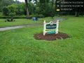
Oh no, I forgot to reserve! :-) @40.5492,-74.6729
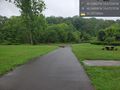
Here's the crossing paths near the hashpoint @40.5490,-74.6727
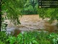
The Raritan is running at least a meter higher than normal, as we've been bombarded with rain the last few days. @40.5490,-74.6728
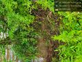
The closest I can get is 48-50 meters. Looking down from the edge into this. (The river bank on the is about 10 meters further out.) @40.5490,-74.6726


