Difference between revisions of "2023-07-18 -37 144"
([live picture]GPS) |
|||
| Line 1: | Line 1: | ||
| − | + | {{meetup graticule | |
| − | |||
| − | |||
| − | |||
| − | |||
| − | |||
| − | |||
| − | |||
| − | |||
| lat=-37 | | lat=-37 | ||
| lon=144 | | lon=144 | ||
| date=2023-07-18 | | date=2023-07-18 | ||
| − | }} | + | }} |
== Location == | == Location == | ||
| − | + | By a pond in the Jawbone Marine Sanctuary, Williamstown | |
== Participants == | == Participants == | ||
| − | + | *[[User:Johnwrw|John]] | |
| − | + | *Bridget | |
| + | *[[User:Stevage]] | ||
| + | *[[User:Lachie]] | ||
| + | *[[User:Felix]] | ||
| + | == Plans == | ||
| + | At 11:32pm, two minutes after the hash was released, Felix messaged the chat "cool one tomorrow!". Lachie responded that he and I (John) had a rehearsal in the evening, but perhaps we could do it afterwards. | ||
| + | |||
| + | Steve replied that he would struggle to squeeze it in. | ||
| + | |||
| + | Meanwhile, although I am often one to check the hashes at 11:30pm when they come out, had been asleep since 10:50pm according to my watch. In the morning, I awoke and checked the hash first thing, and discovered how excellent it was. I then looked at the hash and saw that others were in agreement about its excellence. I suggested to Bridget that we could ride there that morning, and she was keen, even though it was a Tuesday, since she had taken this week off work. I had to make the agonising decision to abandon Lachie and his proposed evening plan, but Bridget wasn't going to be able to join an evening expedition, and I didn't want her to miss out, so we resolved to set off as soon as we were up and breakfasted. | ||
| + | |||
| + | But all was well, Lachie and Felix arranged to have their own evening expedition, so Lachie didn't have to miss out either. When they announced their planned expedition to the chat at twenty past four, it turned out that Steve was already en route to the hash. Cam was tempted to mount a fourth separate expedition, but wasn't going to be able to make it work (as far as I am aware) | ||
| + | |||
| + | == Expedition 1 == | ||
| + | Bridget and I set off into the chilly, but sunny, morning at just after 9, We made our way through the Footscray Hospital district, and crossed the Sunbury line at West Footscray, where you are allowed, encouraged even, to ride up the ramps and along the station overpass. After a fiddly bit getting across Geelong Rd, we reached pleasant backstreets. We rode south, crossed the Westgate at the Fogarty avenue overpass and continued south. We rode across the Newport Lakes reserve, where Bridget had been for a walk, and to visit the nursery, only just the day before. | ||
| + | |||
| + | We then went up Maddox Road, where there is a bike lane/path but it was annoyingly obstacled at times, by roadwork signs and a random truck parked upon it. We got through to the coast safely though. We headed eastwards along the path, and the hash drew ever nearer. With about 400m to go, we stopped and admired some birds: Pied cormorants, in all their large glory in contrast to the more commonly seen little pied cormorants, and black swans. Then we saw a pair of great crested grebes which was very exciting. | ||
| + | |||
| + | We continued riding towards the hash, and after a couple of false stops, where I checked my phone only to discover that there was still some distance off, we got there. The hash itself lay just a few metres into an area planted with little grass bushes. Thankfully not in the thicket just a few metres to the north, or in the lake a few more metres to the south. Easy to pop in and get the snap and screenshot required. We then decided to go home the longer way along the coast via Williamstown. | ||
| + | |||
| + | However, the sunlight we had been enjoying was starting to fade. Over the ocean we could see dark clouds threatening, looming, advancing. Optimistic that any showers might miss us, we continued on. We saw a couple of pelicans, passed the timeball tower, and then started north. We didn't get very far however, only as far as the Nando's in Nelson Place in fact, before the hydrometeors started falling. The heavens opened, and in a flash rain turned to hail. We made a break for the Nando's veranda and considered our options. The radar didn't look promising, so we decided to head for a train in the short break we had before more showers were going to hit. | ||
| + | |||
| + | We went up Parker st, past a church where I once played the last post at an Anzac Day service, my tone being given a generous vibrato from the involuntary shaking of my legs due to nerves. We then went past my old school's gym, and then the school itself, where the schoolkids of today were frolicking in the yard. | ||
| + | |||
| + | We got to the station, and within a few minutes the rain had started again, confirming that our choice to not still be out there peddling was the right one. On our train home, at Newport, several people bedecked in fluro orange got on and appeared to be planning/carrying out some sort of emergency exercise. Thankfully, our trip wasn't interrupted by this. We got off at Footscray, stopped off to check out Footscray market and to get a few last things for the dahl I was planning on bringing to rehearsal that night. We then rode a few more unevenful kilometres back to Maribyrnong and got home just on midday. | ||
| + | |||
| − | == | + | == Expedition 2== |
| − | |||
| − | == Expedition == | + | == Expedition 3== |
| − | |||
== Tracklog == | == Tracklog == | ||
| Line 52: | Line 67: | ||
__NOTOC__ | __NOTOC__ | ||
| − | |||
| − | |||
| − | |||
| − | |||
| − | |||
| − | |||
| − | |||
| − | |||
| − | + | [[Category:Expeditions]] | |
| − | |||
| − | |||
| − | |||
[[Category:Expeditions with photos]] | [[Category:Expeditions with photos]] | ||
| − | + | ||
| − | + | ||
| − | |||
| − | |||
| − | |||
[[Category:Coordinates reached]] | [[Category:Coordinates reached]] | ||
| − | |||
| − | |||
| − | |||
| − | |||
| − | |||
| − | |||
| − | |||
| − | |||
| − | |||
| − | |||
| − | |||
| − | |||
| − | |||
| − | |||
| − | |||
| − | |||
| − | |||
| − | |||
Revision as of 11:06, 18 July 2023
| Tue 18 Jul 2023 in -37,144: -37.8633826, 144.8765444 geohashing.info google osm bing/os kml crox |
Location
By a pond in the Jawbone Marine Sanctuary, Williamstown
Participants
- John
- Bridget
- User:Stevage
- User:Lachie
- User:Felix
Plans
At 11:32pm, two minutes after the hash was released, Felix messaged the chat "cool one tomorrow!". Lachie responded that he and I (John) had a rehearsal in the evening, but perhaps we could do it afterwards.
Steve replied that he would struggle to squeeze it in.
Meanwhile, although I am often one to check the hashes at 11:30pm when they come out, had been asleep since 10:50pm according to my watch. In the morning, I awoke and checked the hash first thing, and discovered how excellent it was. I then looked at the hash and saw that others were in agreement about its excellence. I suggested to Bridget that we could ride there that morning, and she was keen, even though it was a Tuesday, since she had taken this week off work. I had to make the agonising decision to abandon Lachie and his proposed evening plan, but Bridget wasn't going to be able to join an evening expedition, and I didn't want her to miss out, so we resolved to set off as soon as we were up and breakfasted.
But all was well, Lachie and Felix arranged to have their own evening expedition, so Lachie didn't have to miss out either. When they announced their planned expedition to the chat at twenty past four, it turned out that Steve was already en route to the hash. Cam was tempted to mount a fourth separate expedition, but wasn't going to be able to make it work (as far as I am aware)
Expedition 1
Bridget and I set off into the chilly, but sunny, morning at just after 9, We made our way through the Footscray Hospital district, and crossed the Sunbury line at West Footscray, where you are allowed, encouraged even, to ride up the ramps and along the station overpass. After a fiddly bit getting across Geelong Rd, we reached pleasant backstreets. We rode south, crossed the Westgate at the Fogarty avenue overpass and continued south. We rode across the Newport Lakes reserve, where Bridget had been for a walk, and to visit the nursery, only just the day before.
We then went up Maddox Road, where there is a bike lane/path but it was annoyingly obstacled at times, by roadwork signs and a random truck parked upon it. We got through to the coast safely though. We headed eastwards along the path, and the hash drew ever nearer. With about 400m to go, we stopped and admired some birds: Pied cormorants, in all their large glory in contrast to the more commonly seen little pied cormorants, and black swans. Then we saw a pair of great crested grebes which was very exciting.
We continued riding towards the hash, and after a couple of false stops, where I checked my phone only to discover that there was still some distance off, we got there. The hash itself lay just a few metres into an area planted with little grass bushes. Thankfully not in the thicket just a few metres to the north, or in the lake a few more metres to the south. Easy to pop in and get the snap and screenshot required. We then decided to go home the longer way along the coast via Williamstown.
However, the sunlight we had been enjoying was starting to fade. Over the ocean we could see dark clouds threatening, looming, advancing. Optimistic that any showers might miss us, we continued on. We saw a couple of pelicans, passed the timeball tower, and then started north. We didn't get very far however, only as far as the Nando's in Nelson Place in fact, before the hydrometeors started falling. The heavens opened, and in a flash rain turned to hail. We made a break for the Nando's veranda and considered our options. The radar didn't look promising, so we decided to head for a train in the short break we had before more showers were going to hit.
We went up Parker st, past a church where I once played the last post at an Anzac Day service, my tone being given a generous vibrato from the involuntary shaking of my legs due to nerves. We then went past my old school's gym, and then the school itself, where the schoolkids of today were frolicking in the yard.
We got to the station, and within a few minutes the rain had started again, confirming that our choice to not still be out there peddling was the right one. On our train home, at Newport, several people bedecked in fluro orange got on and appeared to be planning/carrying out some sort of emergency exercise. Thankfully, our trip wasn't interrupted by this. We got off at Footscray, stopped off to check out Footscray market and to get a few last things for the dahl I was planning on bringing to rehearsal that night. We then rode a few more unevenful kilometres back to Maribyrnong and got home just on midday.
Expedition 2
Expedition 3
Tracklog
Photos
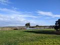
One million swamp/moor-hens
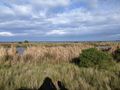
View from hash
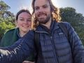
Success!
Bridget at hash
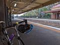
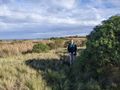
Avoiding inclement weather
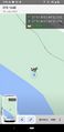
GPS


