Difference between revisions of "2023-08-10 47 8"
Globescorer (talk | contribs) (→Location) |
Globescorer (talk | contribs) (→Expedition) |
||
| (7 intermediate revisions by 3 users not shown) | |||
| Line 1: | Line 1: | ||
{{meetup graticule|date=2023-08-10|lat=47|lon=8}} | {{meetup graticule|date=2023-08-10|lat=47|lon=8}} | ||
| + | [[File:2023-08-10 47 8 The Geohash 02.jpg|600px]] | ||
== Location == | == Location == | ||
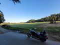
Located at the edge of a planted lawn-turf-field near Alten (ZH). | Located at the edge of a planted lawn-turf-field near Alten (ZH). | ||
| Line 10: | Line 11: | ||
== Expedition == | == Expedition == | ||
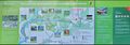
| − | + | In this morning before work I visited this Hashpoint by motorcycle. After a 7km ride I parked the bike as close to the coordinates as possible. Before that I made a stop before and after the nearby wooden bridge. An information board on the "Thurauen" nature reserve contains a lot of interesting facts about this area on the river. Then it is only a short distance to the Hashpoint. | |
| + | |||
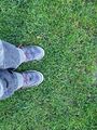
| + | I walked the last few meters and was lucky that the coordinates are almost on the edge of a field. A field that has been prepared to harvest turf. or how to tell the lawn, which you can buy and then roll out in the garden. I've never seen that live before. So I took the necessary photos and screenshots for the community and then drove on to the office. | ||
== Photos == | == Photos == | ||
| Line 16: | Line 19: | ||
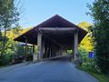
File:2023-08-10 47 8 Bridge 01.jpg |The wooden bridge nearby | File:2023-08-10 47 8 Bridge 01.jpg |The wooden bridge nearby | ||
File:2023-08-10 47 8 Bridge 02.jpg |The wooden bridge nearby | File:2023-08-10 47 8 Bridge 02.jpg |The wooden bridge nearby | ||
| − | |||
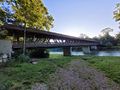
File:2023-08-10 47 8 Thur 02.jpg |The river Thur | File:2023-08-10 47 8 Thur 02.jpg |The river Thur | ||
| + | </gallery> | ||
| + | [[File:2023-08-10 47 8 Thur 01.jpg|1000px]] | ||
| + | <gallery> | ||
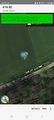
File:2023-08-10 47 8 The Geohash.jpg |The Geohash | File:2023-08-10 47 8 The Geohash.jpg |The Geohash | ||
File:2023-08-10 47 8 The Geohash 02.jpg |view to the hashpoint | File:2023-08-10 47 8 The Geohash 02.jpg |view to the hashpoint | ||
| Line 25: | Line 30: | ||
File:2023-08-10 47 8 The Sign.JPG |A sign nearby with position of the Geohash | File:2023-08-10 47 8 The Sign.JPG |A sign nearby with position of the Geohash | ||
</gallery> | </gallery> | ||
| + | [[File:2023-08-10 47 8 Panorama.jpg|1000px]] | ||
| + | |||
| + | [[Category:Expeditions]] | ||
| + | [[Category:Expeditions with photos]] | ||
| + | [[Category:Coordinates reached]] | ||
| + | {{location|CH|ZH}} | ||
Latest revision as of 13:28, 10 August 2023
| Thu 10 Aug 2023 in 47,8: 47.5923109, 8.6470764 geohashing.info google osm bing/os kml crox |

Contents
Location
Located at the edge of a planted lawn-turf-field near Alten (ZH).
Participants
Plans
In this morning before work I wanted to visit this Hashpoint by motorcycle.
Expedition
In this morning before work I visited this Hashpoint by motorcycle. After a 7km ride I parked the bike as close to the coordinates as possible. Before that I made a stop before and after the nearby wooden bridge. An information board on the "Thurauen" nature reserve contains a lot of interesting facts about this area on the river. Then it is only a short distance to the Hashpoint.
I walked the last few meters and was lucky that the coordinates are almost on the edge of a field. A field that has been prepared to harvest turf. or how to tell the lawn, which you can buy and then roll out in the garden. I've never seen that live before. So I took the necessary photos and screenshots for the community and then drove on to the office.
Photos
The wooden bridge nearby
The wooden bridge nearby

The river Thur


The Geohash
view to the hashpoint
The Proof
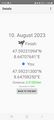
Another Proof
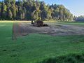
grass-turf to roll out
A sign nearby with position of the Geohash


