Difference between revisions of "2023-08-24 49 10"
| Line 7: | Line 7: | ||
And DON'T FORGET to add your expedition and the best photo you took to the gallery on the Main Page! We'd love to read your report, but that means we first have to discover it! :) | And DON'T FORGET to add your expedition and the best photo you took to the gallery on the Main Page! We'd love to read your report, but that means we first have to discover it! :) | ||
| − | -->{{meetup graticule | + | --> |
| + | {{meetup graticule | ||
| lat={{#explode:{{SUBPAGENAME}}| |1}} | | lat={{#explode:{{SUBPAGENAME}}| |1}} | ||
| lon={{#explode:{{SUBPAGENAME}}| |2}} | | lon={{#explode:{{SUBPAGENAME}}| |2}} | ||
| date={{#explode:{{SUBPAGENAME}}| |0}} | | date={{#explode:{{SUBPAGENAME}}| |0}} | ||
| − | }} | + | }} |
| + | |||
== Location == | == Location == | ||
| − | + | field northwest of Möhrendorf, Bavaria, Germany | |
== Participants == | == Participants == | ||
* [[User:Klaus|Klaus]] | * [[User:Klaus|Klaus]] | ||
| + | |||
== Plans == | == Plans == | ||
Noticed the hash on noon, will go for a long run (approximately ~15km back and forth) in the evening before sunset. 15km are twice the distance I usually run, so I will limit myself to running very slowly (probably 7:00min/km) in order to avoid hurting myself. This means it will take me almost 2 hours. | Noticed the hash on noon, will go for a long run (approximately ~15km back and forth) in the evening before sunset. 15km are twice the distance I usually run, so I will limit myself to running very slowly (probably 7:00min/km) in order to avoid hurting myself. This means it will take me almost 2 hours. | ||
| Line 24: | Line 27: | ||
Also, this is my first hash where I will try "run" to and not just walk. Need to lookup if there is an extra achievement for this ;) | Also, this is my first hash where I will try "run" to and not just walk. Need to lookup if there is an extra achievement for this ;) | ||
== Expedition == | == Expedition == | ||
| − | + | I didn't run. This had two reasons: First, I started to late and would have probably gotten into darkness. No problem, I have a headlight, but not really fun, too. Second, I already wrote above that I am running regularly, but never 15km and you can easily hurt yourself if you overdo running. So I made a bicycle tour which was a good idea because it started to rain on the way back and I just returned before getting completly soaked. | |
| + | |||
| + | However, before I started I noticed that I can try the Tron achievement! I would have to drive a little more distance, but the tour itself was pretty normal, except that it was the first time I had to take my bicycle with me while crossing a field. The way back was worse than the way to the geohash because I trusted OpenStreetmap and some roads which turned out to be overgrown tractor tracks. After some time I got back to a road which was cyclable and drove home. | ||
== Tracklog == | == Tracklog == | ||
| − | < | + | <gallery perrow="5"> |
| + | Image:2023-08-24_49_10_pic14_tracklog.png | Tracklog of whole route (cut of at bottom for privacy, but inside Erlangen it is easy to avoid crossing the same road) | ||
| + | Image:2023-08-24_49_10_pic15_tracklog2.png | Tracklog of area with geohash | ||
| + | </gallery> | ||
| + | == Photos == | ||
| − | |||
| − | |||
| − | |||
| − | |||
<gallery perrow="5"> | <gallery perrow="5"> | ||
| + | Image:2023-08-24_49_10_pic01_next_to_autobahn.jpeg | Driving next to A73 highway | ||
| + | Image:2023-08-24_49_10_pic02_up_the_hill.jpeg | leaving paved roads, up the hill | ||
| + | Image:2023-08-24_49_10_pic03_streets_getting_worse.jpeg | Streets getting worse and worse as I am closing in on the geohash | ||
| + | Image:2023-08-24_49_10_pic04_field_with_geohash_during_approach.jpeg | somewhere on this harvested field | ||
| + | Image:2023-08-24_49_10_pic05_geohash1.jpeg | View from Geohash #1 | ||
| + | Image:2023-08-24_49_10_pic06_geohash2.jpeg | View from Geohash #2 | ||
| + | Image:2023-08-24_49_10_pic06_geohash3.jpeg | View from Geohash #3 | ||
| + | Image:2023-08-24_49_10_pic06_geohash4.jpeg | View from Geohash #4 | ||
| + | Image:2023-08-24_49_10_pic08_geohash5_bicycle.jpeg | View from Geohash #5 (I took my bicycle to geohash) | ||
| + | Image:2023-08-24_49_10_pic09_view_back_to_geohash.jpeg | View back to geohash after crossing field | ||
| + | Image:2023-08-24_49_10_pic10_forest_roads.jpeg | This road got worse and worse | ||
| + | Image:2023-08-24_49_10_pic11_back_to_normal_street.jpeg | finally, a normal road :) | ||
| + | Image:2023-08-24_49_10_pic12_bicycle_way_under_construction.jpeg | bicycle lane of ERH 31 is currently under construction | ||
| + | Image:2023-08-24_49_10_pic13_proof.png | Proof | ||
</gallery> | </gallery> | ||
== Achievements == | == Achievements == | ||
{{#vardefine:ribbonwidth|100%}} | {{#vardefine:ribbonwidth|100%}} | ||
| − | + | {{land geohash | |
| + | | latitude = 49 | ||
| + | | longitude = 10 | ||
| + | | date = 2023-08-24 | ||
| + | | name = [[User:Klaus|Klaus]] | ||
| + | }} | ||
| − | + | {{bicycle geohash | |
| − | + | | latitude = 49 | |
| − | + | | longitude = 10 | |
| − | [[ | + | | date = 2023-08-24 |
| + | | name = [[User:Klaus|Klaus]] | ||
| + | | distance = 16km | ||
| + | | bothways = true | ||
| + | }} | ||
| − | + | {{Tron | latitude = 49 | longitude = 10 | date = 2023-08-24 | name = Klaus | tracklog = https://geohashing.site/geohashing/2023-08-24_49_10#Tracklog | possessive = his | image = 2023-08-24_49_10_pic14_tracklog.png }} | |
| − | + | __NOTOC__ | |
| − | |||
| − | |||
| − | |||
| − | |||
| − | |||
| − | |||
[[Category:Expeditions]] | [[Category:Expeditions]] | ||
| − | |||
[[Category:Expeditions with photos]] | [[Category:Expeditions with photos]] | ||
| − | |||
| − | |||
| − | |||
| − | |||
| − | |||
[[Category:Coordinates reached]] | [[Category:Coordinates reached]] | ||
| − | |||
| − | |||
| − | |||
| − | |||
| − | |||
| − | |||
| − | |||
| − | |||
| − | |||
| − | |||
| − | |||
| − | |||
| − | |||
| − | |||
| − | |||
| − | |||
| − | |||
| − | |||
Revision as of 20:45, 24 August 2023
| Thu 24 Aug 2023 in 49,10: 49.6450231, 10.9805885 geohashing.info google osm bing/os kml crox |
Location
field northwest of Möhrendorf, Bavaria, Germany
Participants
Plans
Noticed the hash on noon, will go for a long run (approximately ~15km back and forth) in the evening before sunset. 15km are twice the distance I usually run, so I will limit myself to running very slowly (probably 7:00min/km) in order to avoid hurting myself. This means it will take me almost 2 hours.
With this hash, I can finally get the 49,10 graticule which I attempted once in my last attempt before stopping geohashing for 6 years. As I moved from Tübingen to Erlangen in those 6 years and live very close to 49,10 it is now much easier to get this graticule and was just a matter of time to get a hash close to the graticule border.
Also, this is my first hash where I will try "run" to and not just walk. Need to lookup if there is an extra achievement for this ;)
Expedition
I didn't run. This had two reasons: First, I started to late and would have probably gotten into darkness. No problem, I have a headlight, but not really fun, too. Second, I already wrote above that I am running regularly, but never 15km and you can easily hurt yourself if you overdo running. So I made a bicycle tour which was a good idea because it started to rain on the way back and I just returned before getting completly soaked.
However, before I started I noticed that I can try the Tron achievement! I would have to drive a little more distance, but the tour itself was pretty normal, except that it was the first time I had to take my bicycle with me while crossing a field. The way back was worse than the way to the geohash because I trusted OpenStreetmap and some roads which turned out to be overgrown tractor tracks. After some time I got back to a road which was cyclable and drove home.
Tracklog
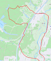
Tracklog of whole route (cut of at bottom for privacy, but inside Erlangen it is easy to avoid crossing the same road)
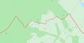
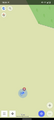
Tracklog of area with geohash


Photos
Driving next to A73 highway
leaving paved roads, up the hill
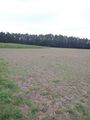
Streets getting worse and worse as I am closing in on the geohash
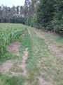
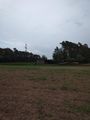
somewhere on this harvested field
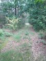
View from Geohash #1
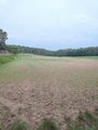
View from Geohash #2
View from Geohash #3
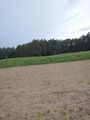
View from Geohash #4
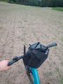
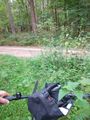
View from Geohash #5 (I took my bicycle to geohash)
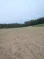
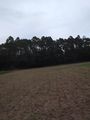
View back to geohash after crossing field
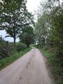
This road got worse and worse
finally, a normal road :)
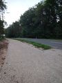
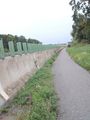
bicycle lane of ERH 31 is currently under construction
Proof


Achievements
Klaus earned the Land geohash achievement
|
Klaus earned the Bicycle geohash achievement
|
Klaus earned the Tron achievement
|