Difference between revisions of "2023-09-05 47 8"
Globescorer (talk | contribs) (→Photos) |
(Categories) |
||
| (10 intermediate revisions by one other user not shown) | |||
| Line 13: | Line 13: | ||
== Expedition == | == Expedition == | ||
| − | + | ||
| + | And so it was. Exactly as I had planned, I cycled this route. On the way I fished a geocache and took a few photos from time to time. For the whole loop (15.0km) I needed 1h 17min. Since I only use the bike a few times and don't have a pro bike anyway, I'm glad I was able to cover the distance reasonably well. | ||
| + | |||
| + | I recorded the route using the ramblr app. But I still don't know how to include this data here... We'll see... | ||
| + | |||
| + | So I drove off from the small village of Niederwil. The trickiest thing was getting across the river without crossing paths, which would take away my chance at the TRON achievement. So I decided on the car bridge near Gütighausen on the way there and the well-known railway bridge on the way back. | ||
| + | |||
| + | From Wiki: | ||
| + | The principal civil engineering structure on the line is the [https://de.m.wikipedia.org/wiki/Thurbr%C3%BCcke_Ossingen Thurbrücke Ossingen], a 332 metres (1,089 ft) long and 42 metres (138 ft) high five-span truss bridge over the River Thur. | ||
== Photos == | == Photos == | ||
| Line 43: | Line 51: | ||
</gallery> | </gallery> | ||
[[File:2023-09-05 47 8 bicycle.jpg|500px]] my bicycle... | [[File:2023-09-05 47 8 bicycle.jpg|500px]] my bicycle... | ||
| + | |||
| + | ==Tracklog== | ||
| + | <gallery> | ||
| + | File:2023-09-05 47 8 TRON 1.jpg | ||
| + | File:2023-09-05 47 8 TRON 2.jpg | ||
| + | </gallery> | ||
==Achievements== | ==Achievements== | ||
| Line 57: | Line 71: | ||
{{land geohash|date=2023-09-05|latitude=47|longitude=8|name=[[User:globescorer|globescorer]]|image=2023-09-05 47 8 The Geohash.jpg}} | {{land geohash|date=2023-09-05|latitude=47|longitude=8|name=[[User:globescorer|globescorer]]|image=2023-09-05 47 8 The Geohash.jpg}} | ||
| − | + | __NOTOC__ | |
| − | [[Category: | + | [[Category:Expeditions]] |
| + | [[Category:Expeditions with photos]] | ||
| + | [[Category:Coordinates reached]] | ||
{{location|CH|ZH}} | {{location|CH|ZH}} | ||
Latest revision as of 09:06, 10 September 2023
| Tue 5 Sep 2023 in 47,8: 47.6204576, 8.7357352 geohashing.info google osm bing/os kml crox |
Location
Located in a field near Ossingen (ZH), Switzerland.
Participants
Plans
In the evening I want to achieve a geohash by bike for the first time. And this like a Tron! That would give me 2 new achievements. All in all, that's about 15km to ride. I'll get there around 6:45pm.
 Planned route...
Expedition
And so it was. Exactly as I had planned, I cycled this route. On the way I fished a geocache and took a few photos from time to time. For the whole loop (15.0km) I needed 1h 17min. Since I only use the bike a few times and don't have a pro bike anyway, I'm glad I was able to cover the distance reasonably well.
I recorded the route using the ramblr app. But I still don't know how to include this data here... We'll see...
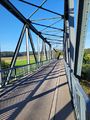
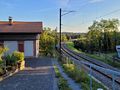
So I drove off from the small village of Niederwil. The trickiest thing was getting across the river without crossing paths, which would take away my chance at the TRON achievement. So I decided on the car bridge near Gütighausen on the way there and the well-known railway bridge on the way back.
From Wiki: The principal civil engineering structure on the line is the Thurbrücke Ossingen, a 332 metres (1,089 ft) long and 42 metres (138 ft) high five-span truss bridge over the River Thur.
Photos
First bridge is the road bridge in Gütighausen
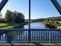
bridge view east
bridge view west
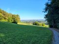
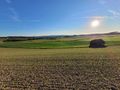
view from above the wineyards towards the mountain Säntis
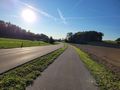
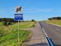
on the way
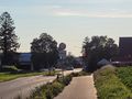
sign from the village Ossingen (for the first time)


then leaving Ossingen towards hashpoint (located somewhere at the horizon behind the sign)
The Geohash
The view from the Geohash to west
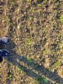
The Proof
Another Proof
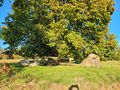
these are memorial stones nearby from a local family


approaching the railway bridge
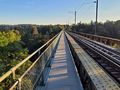
The famos railway bridge
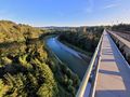
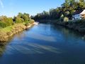
view to the east
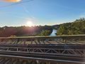
view to the west
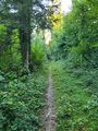
On the way
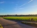
view to Niederwil


 my bicycle...
Tracklog


Achievements
globescorer earned the Bicycle geohash achievement
|
globescorer earned the Tron achievement
|
globescorer earned the Land geohash achievement
|