Difference between revisions of "2023-09-08 51 4"
FelixTheCat (talk | contribs) (Created page with "{{subst:Expedition |lat = 51 |lon = 4 |date = 2023-09-08 }}") |
FelixTheCat (talk | contribs) |
||
| Line 1: | Line 1: | ||
| − | + | {{meetup graticule | |
| − | |||
| − | |||
| − | |||
| − | |||
| − | |||
| − | |||
| − | |||
| − | |||
| lat=51 | | lat=51 | ||
| lon=4 | | lon=4 | ||
| date=2023-09-08 | | date=2023-09-08 | ||
| − | }} | + | }} |
== Location == | == Location == | ||
| − | + | In a park in Krimpen aan den IJssel, South Holland province. | |
== Participants == | == Participants == | ||
| − | + | [[User:FelixTheCat|FelixTheCat]] ([[User talk:FelixTheCat|talk]]) | |
| − | |||
| − | |||
| − | |||
| − | |||
== Expedition == | == Expedition == | ||
| − | + | Today's hash was in a park in the town of Krimpen aan den IJssel. This is mostly a commuter town on the edge of Rotterdam. It's slightly inconvenient to reach by public transport since there are no train, tram or metro connections: the only way to get there is by bus. Still, it would only take about an hour to get there, so I went for it. I took the train from Delft to Rotterdam Blaak, then the Metro to Capelsebrug, followed by a bus to Krimpen. I found the park, but when I tried to get to the hashpoint, it turned out to be in water that wasn't shown on either Google Maps or Openstreetmap. I recorded my failure and then walked around the town a bit, before taking the bus, metro and train back home. | |
| − | |||
| − | |||
| − | |||
== Photos == | == Photos == | ||
| − | |||
| − | |||
| − | |||
<gallery perrow="5"> | <gallery perrow="5"> | ||
| + | Image:2023-09-08 51 4 FelixTheCat 1.JPG | The Sprinter train from Delft to Rotterdam Blaak. | ||
| + | Image:2023-09-08 51 4 FelixTheCat 2.JPG | The Metro line B from Blaak to Capelsebrug. | ||
| + | Image:2023-09-08 51 4 FelixTheCat 3.JPG | The number 196 bus from Capelsebrug to Wilhelminahoeve in Krimpen. | ||
| + | Image:2023-09-08 51 4 FelixTheCat 4.JPG | The sunlight through the trees makes for a beautiful scene. Perhaps a bit less beautiful if you realise that the country is on smog alert these days. | ||
| + | Image:2023-09-08 51 4 FelixTheCat 5.JPG | This tree has separate homes for little owls (''Athene noctua'') and for bats. | ||
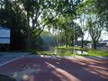
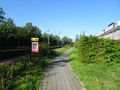
| + | Image:2023-09-08 51 4 FelixTheCat 6.JPG | Our destination is apparently called Park Boveneind. | ||
| + | Image:2023-09-08 51 4 FelixTheCat 7.JPG | The point is somewhere around here. But that water isn't supposed to be there... | ||
| + | Image:2023-09-08 51 4 FelixTheCat 8.png | GPS reception is not great, but we've definitely not reached the point. | ||
| + | Image:2023-09-08 51 4 FelixTheCat 9.JPG | Lloyd is disappointed. | ||
| + | Image:2023-09-08 51 4 FelixTheCat 10.JPG | The estate agent selling this house has a sense of humour: instead of hanging up a "sold" sign, they wrote "too late". | ||
</gallery> | </gallery> | ||
== Achievements == | == Achievements == | ||
{{#vardefine:ribbonwidth|100%}} | {{#vardefine:ribbonwidth|100%}} | ||
| − | + | {{My kingdom for a boat | |
| + | | latitude = 51 | ||
| + | | longitude = 4 | ||
| + | | date = 2023-09-08 | ||
| + | | name = [[User:FelixTheCat|FelixTheCat]] ([[User talk:FelixTheCat|talk]]) | ||
| + | | waterhazard = watercourse | ||
| + | }} | ||
__NOTOC__ | __NOTOC__ | ||
| − | |||
| − | |||
| − | |||
| − | |||
| − | |||
| − | |||
| − | |||
| − | |||
| − | |||
| − | |||
| − | |||
| − | |||
| − | |||
| − | |||
[[Category:Expeditions]] | [[Category:Expeditions]] | ||
| − | |||
[[Category:Expeditions with photos]] | [[Category:Expeditions with photos]] | ||
| − | |||
| − | |||
| − | |||
| − | |||
| − | |||
| − | |||
| − | |||
| − | |||
| − | |||
[[Category:Coordinates not reached]] | [[Category:Coordinates not reached]] | ||
| − | |||
| − | |||
[[Category:Not reached - Mother Nature]] | [[Category:Not reached - Mother Nature]] | ||
| − | |||
| − | |||
| − | |||
| − | |||
| − | |||
| − | |||
| − | |||
| − | |||
| − | |||
| − | |||
| − | |||
Revision as of 08:47, 9 September 2023
| Fri 8 Sep 2023 in 51,4: 51.9223781, 4.6164133 geohashing.info google osm bing/os kml crox |
Location
In a park in Krimpen aan den IJssel, South Holland province.
Participants
Expedition
Today's hash was in a park in the town of Krimpen aan den IJssel. This is mostly a commuter town on the edge of Rotterdam. It's slightly inconvenient to reach by public transport since there are no train, tram or metro connections: the only way to get there is by bus. Still, it would only take about an hour to get there, so I went for it. I took the train from Delft to Rotterdam Blaak, then the Metro to Capelsebrug, followed by a bus to Krimpen. I found the park, but when I tried to get to the hashpoint, it turned out to be in water that wasn't shown on either Google Maps or Openstreetmap. I recorded my failure and then walked around the town a bit, before taking the bus, metro and train back home.
Photos
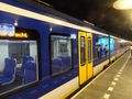
The Sprinter train from Delft to Rotterdam Blaak.
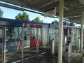
The Metro line B from Blaak to Capelsebrug.
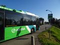
The number 196 bus from Capelsebrug to Wilhelminahoeve in Krimpen.
The sunlight through the trees makes for a beautiful scene. Perhaps a bit less beautiful if you realise that the country is on smog alert these days.
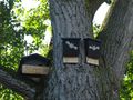
This tree has separate homes for little owls (Athene noctua) and for bats.
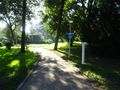
Our destination is apparently called Park Boveneind.
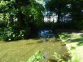
The point is somewhere around here. But that water isn't supposed to be there...
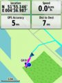
GPS reception is not great, but we've definitely not reached the point.
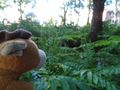
Lloyd is disappointed.
The estate agent selling this house has a sense of humour: instead of hanging up a "sold" sign, they wrote "too late".


Achievements
FelixTheCat (talk) earned the My kingdom for a boat consolation prize
|