Difference between revisions of "2023-09-13 51 5"
FelixTheCat (talk | contribs) (Created page with "{{subst:Expedition |lat = 51 |lon = 5 |date = 2023-09-13 }}") |
FelixTheCat (talk | contribs) |
||
| Line 1: | Line 1: | ||
| − | + | {{meetup graticule | |
| − | |||
| − | |||
| − | |||
| − | |||
| − | |||
| − | |||
| − | |||
| − | |||
| lat=51 | | lat=51 | ||
| lon=5 | | lon=5 | ||
| date=2023-09-13 | | date=2023-09-13 | ||
| − | }} | + | }} |
== Location == | == Location == | ||
| − | + | In a park in Eindhoven, North Brabant province. | |
== Participants == | == Participants == | ||
| − | + | [[User:FelixTheCat|FelixTheCat]] ([[User talk:FelixTheCat|talk]]) | |
| − | |||
| − | |||
| − | |||
| − | |||
== Expedition == | == Expedition == | ||
| − | + | I was determined to finally reach a point again after two unexpected failures. Since today's seemed to be in a public park in Eindhoven, my chances were looking good. I took the train from Delft to Eindhoven, planning to rent a bike at the station and ride to the hash. Unfortunately, all bikes were rented out already, so I had to take a bus instead. This turned out to be a good choice, because a huge downpour occurred just a few minutes after we left the station. Luckily, it had stopped raining again when we reached the Meerrijk bus stop. I walked to the park and found that the hash field had been turned into a public cricket field. Cricket isn't a particularly popular sport here; I found out later that a group of expats living nearby took the initiative to establish this facility. The field was still fully open to the public however, so it was easy to get to the hashpoint. After logging the point I walked through the park a bit more and climbed a hill to look at airplanes taking off from Eindhoven Airport. As I walked back to the bus stop I heard a thundering noise and looked back, just in time to spot an F-35 flying off into the clouds. | |
| − | |||
| − | |||
| − | |||
== Photos == | == Photos == | ||
| − | |||
| − | |||
| − | |||
<gallery perrow="5"> | <gallery perrow="5"> | ||
| + | Image:2023-09-13 51 5 FelixTheCat 1.JPG | Bus 401 takes us to a very wet Meerrijk. | ||
| + | Image:2023-09-13 51 5 FelixTheCat 2.JPG | After walking through a shopping centre, we reach the park using this bridge. | ||
| + | Image:2023-09-13 51 5 FelixTheCat 3.JPG | The hashfield is fenced off, but it's open to the public. | ||
| + | Image:2023-09-13 51 5 FelixTheCat 4.png | Reached it! | ||
| + | Image:2023-09-13 51 5 FelixTheCat 5.JPG | Lloyd and Trix are celebrating. | ||
| + | Image:2023-09-13 51 5 FelixTheCat 6.JPG | Looking northeast, with the pitch visible. | ||
| + | Image:2023-09-13 51 5 FelixTheCat 7.JPG | Looking southwest. There are a few young trees. | ||
| + | Image:2023-09-13 51 5 FelixTheCat 8.JPG | There are cows in the field next door. Apparently they're an old breed that has become quite rare. | ||
| + | Image:2023-09-13 51 5 FelixTheCat 9.JPG | There's a path through with these signs describing the history of Eindhoven Airport. They were installed to celebrate the airport's 90th anniversary. | ||
</gallery> | </gallery> | ||
== Achievements == | == Achievements == | ||
{{#vardefine:ribbonwidth|100%}} | {{#vardefine:ribbonwidth|100%}} | ||
| − | + | {{Public transport geohash | |
| + | | latitude = 51 | ||
| + | | longitude = 5 | ||
| + | | date = 2023-09-13 | ||
| + | | busline = Intercity train and Bus 401 | ||
| + | | name = [[User:FelixTheCat|FelixTheCat]] ([[User talk:FelixTheCat|talk]]) | ||
| + | }} | ||
__NOTOC__ | __NOTOC__ | ||
| − | |||
| − | |||
| − | |||
| − | |||
| − | |||
| − | |||
| − | |||
| − | |||
| − | |||
| − | |||
| − | |||
| − | |||
| − | |||
| − | |||
[[Category:Expeditions]] | [[Category:Expeditions]] | ||
| − | |||
[[Category:Expeditions with photos]] | [[Category:Expeditions with photos]] | ||
| − | |||
| − | |||
| − | |||
| − | |||
| − | |||
[[Category:Coordinates reached]] | [[Category:Coordinates reached]] | ||
| − | |||
| − | |||
| − | |||
| − | |||
| − | |||
| − | |||
| − | |||
| − | |||
| − | |||
| − | |||
| − | |||
| − | |||
| − | |||
| − | |||
| − | |||
| − | |||
| − | |||
| − | |||
Revision as of 16:20, 14 September 2023
| Wed 13 Sep 2023 in 51,5: 51.4412237, 5.4043372 geohashing.info google osm bing/os kml crox |
Location
In a park in Eindhoven, North Brabant province.
Participants
Expedition
I was determined to finally reach a point again after two unexpected failures. Since today's seemed to be in a public park in Eindhoven, my chances were looking good. I took the train from Delft to Eindhoven, planning to rent a bike at the station and ride to the hash. Unfortunately, all bikes were rented out already, so I had to take a bus instead. This turned out to be a good choice, because a huge downpour occurred just a few minutes after we left the station. Luckily, it had stopped raining again when we reached the Meerrijk bus stop. I walked to the park and found that the hash field had been turned into a public cricket field. Cricket isn't a particularly popular sport here; I found out later that a group of expats living nearby took the initiative to establish this facility. The field was still fully open to the public however, so it was easy to get to the hashpoint. After logging the point I walked through the park a bit more and climbed a hill to look at airplanes taking off from Eindhoven Airport. As I walked back to the bus stop I heard a thundering noise and looked back, just in time to spot an F-35 flying off into the clouds.
Photos
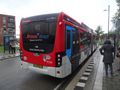
Bus 401 takes us to a very wet Meerrijk.
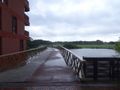
After walking through a shopping centre, we reach the park using this bridge.
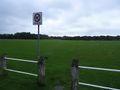
The hashfield is fenced off, but it's open to the public.
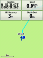
Reached it!

Lloyd and Trix are celebrating.

Looking northeast, with the pitch visible.
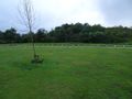
Looking southwest. There are a few young trees.
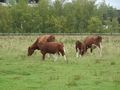
There are cows in the field next door. Apparently they're an old breed that has become quite rare.
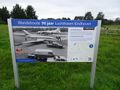
There's a path through with these signs describing the history of Eindhoven Airport. They were installed to celebrate the airport's 90th anniversary.


Achievements
FelixTheCat (talk) earned the Public transport geohash achievement
|