Difference between revisions of "2023-09-18 -37 145"
([retro picture]Cows) |
|||
| Line 1: | Line 1: | ||
| − | + | {{meetup graticule | |
| − | |||
| − | |||
| − | |||
| − | |||
| − | |||
| − | |||
| − | |||
| − | |||
| lat=-37 | | lat=-37 | ||
| lon=145 | | lon=145 | ||
| date=2023-09-18 | | date=2023-09-18 | ||
| − | }} | + | }} |
== Location == | == Location == | ||
| − | + | In bush by the side of Diamond Creek (the creek itself) | |
== Participants == | == Participants == | ||
| − | + | *[[User:Johnwrw|John]] | |
| − | + | *[[User:Stevage|Steve]] | |
| + | |||
| + | |||
| + | == Expedition 1 (John)== | ||
| + | |||
| + | The hash was appealing, but it was a long way away from me in Maribyrnong, so it took a while for me to make up my mind. At around 3, I decided that I had done enough work for the day and that I would launch an efficient speedy train both ways expedition, and be back in time for dinner. Trains both ways still necessitated a not insignificant ride to catch a train. | ||
| + | |||
| + | After some confusion, where I wanted to catch the train from Westgarth, but trains from there didn't seem to be going past Greensborough, I realised that the trains that go all the way to Diamond Creek/Hurstbridge were running express through Westgarth. I had to go to Clifton Hill instead. I eventually bundled myself out the door at 3:13, with exactly 35 minutes to ride a bit over 12 Ks across the city. A challenge when you consider the stop-start nature of city riding. I was pretty much flat out the whole way, but I got there with a few minutes to spare. | ||
| + | |||
| + | The train journey passed without drama, and I got to Diamond Creek station on time at 4:25. My plan was to ride the 6 or so Ks down along the path that follows the creek down to Eltham, where I could get a train home, naturally stopping to pick up the geohash on the way. If I was very efficient I might even make the 5pm train. | ||
| + | |||
| + | The path was lovely, the air was warm but had that freshness to it that comes from there being so much vegetation around. The ear-splitting screams of cockatoos only added to the serenity. I also spotted a couple of birds that I thought were probably common bronzewings (whose prettiness is undeserving of the 'common' name), but I didn't get a good glimpse of them. | ||
| + | |||
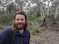
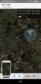
| + | I neared the hash, so I hid my bike just off the path, and ploughed into the bush. It was actually quite open, it seemed to be a lot of dried out pools that I'm sure will soon fill again next time it rains to any great extent. The GPS dance took longer than usual, but I eventually got a sub 1m reading. I returned to my bike, and continued on my way. I resigned myself to the fact that I was going to miss the 5pm train, so my onward progress was leisurely. Getting back closer to Eltham I came across a few inquisitive cows. I also passed several other farm animals. | ||
| + | |||
| + | Before I knew it, I was in Eltham and waiting on the platform for the 5:20 train. It arrived on time, and then in a flash I was at Westgarth. After a slow start, waiting for a train the other way at the level crossing, and then just missing the lights at High St, I got back to the inner circle trail, and rode home via royal park and the stock route, (and a quick visit to cheaper by miles). | ||
| + | |||
| + | I got home before 7, having done 31.8km by bike, and many more by train. I relaxed that evening watching [https://www.youtube.com/watch?v=UoYTKjvgsnk&ab_channel=Taitset a 40minute youtube video] all about the train line that had served me that day. | ||
| + | |||
| − | == | + | == Expedition 2 == |
| − | |||
| − | |||
| − | |||
| − | |||
| − | |||
== Photos == | == Photos == | ||
| Line 46: | Line 51: | ||
__NOTOC__ | __NOTOC__ | ||
| − | |||
| − | |||
| − | |||
| − | + | [[Category:Expeditions]] | |
| − | + | [[Category:Expeditions with photos]] | |
| − | |||
| − | [[Category: | ||
| − | |||
| − | |||
| − | + | ||
| − | |||
| − | |||
| − | |||
| − | |||
| − | |||
| − | |||
| − | |||
| − | |||
[[Category:Coordinates reached]] | [[Category:Coordinates reached]] | ||
| − | |||
| − | |||
| − | |||
| − | |||
| − | |||
| − | |||
| − | |||
| − | |||
| − | |||
| − | |||
| − | |||
| − | |||
| − | |||
| − | |||
| − | |||
| − | |||
| − | |||
| − | |||
Revision as of 13:03, 19 September 2023
| Mon 18 Sep 2023 in -37,145: -37.6846499, 145.1546602 geohashing.info google osm bing/os kml crox |
Location
In bush by the side of Diamond Creek (the creek itself)
Participants
Expedition 1 (John)
The hash was appealing, but it was a long way away from me in Maribyrnong, so it took a while for me to make up my mind. At around 3, I decided that I had done enough work for the day and that I would launch an efficient speedy train both ways expedition, and be back in time for dinner. Trains both ways still necessitated a not insignificant ride to catch a train.
After some confusion, where I wanted to catch the train from Westgarth, but trains from there didn't seem to be going past Greensborough, I realised that the trains that go all the way to Diamond Creek/Hurstbridge were running express through Westgarth. I had to go to Clifton Hill instead. I eventually bundled myself out the door at 3:13, with exactly 35 minutes to ride a bit over 12 Ks across the city. A challenge when you consider the stop-start nature of city riding. I was pretty much flat out the whole way, but I got there with a few minutes to spare.
The train journey passed without drama, and I got to Diamond Creek station on time at 4:25. My plan was to ride the 6 or so Ks down along the path that follows the creek down to Eltham, where I could get a train home, naturally stopping to pick up the geohash on the way. If I was very efficient I might even make the 5pm train.
The path was lovely, the air was warm but had that freshness to it that comes from there being so much vegetation around. The ear-splitting screams of cockatoos only added to the serenity. I also spotted a couple of birds that I thought were probably common bronzewings (whose prettiness is undeserving of the 'common' name), but I didn't get a good glimpse of them.
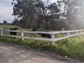
I neared the hash, so I hid my bike just off the path, and ploughed into the bush. It was actually quite open, it seemed to be a lot of dried out pools that I'm sure will soon fill again next time it rains to any great extent. The GPS dance took longer than usual, but I eventually got a sub 1m reading. I returned to my bike, and continued on my way. I resigned myself to the fact that I was going to miss the 5pm train, so my onward progress was leisurely. Getting back closer to Eltham I came across a few inquisitive cows. I also passed several other farm animals.
Before I knew it, I was in Eltham and waiting on the platform for the 5:20 train. It arrived on time, and then in a flash I was at Westgarth. After a slow start, waiting for a train the other way at the level crossing, and then just missing the lights at High St, I got back to the inner circle trail, and rode home via royal park and the stock route, (and a quick visit to cheaper by miles).
I got home before 7, having done 31.8km by bike, and many more by train. I relaxed that evening watching a 40minute youtube video all about the train line that had served me that day.
Expedition 2
Photos
Success
GPS proof
Cows


