Difference between revisions of "2023-09-27 49 12"
(Created page with "{{subst:Expedition2}}") |
|||
| Line 11: | Line 11: | ||
}} | }} | ||
== Location == | == Location == | ||
| − | + | close to the shore of a lake in Leonberg, Landkreis Tirschenreuth, Germany | |
== Participants == | == Participants == | ||
| − | + | * [[User:Klaus|Klaus]] | |
| − | * [[User: | ||
| − | |||
== Plans == | == Plans == | ||
| − | + | My family is going for a short vacation in Karlovy Vary, Czechia. This hash is more or less on the drive there, so let's try to get a new graticule! | |
== Expedition == | == Expedition == | ||
| + | We left A93 on Mitterteich-Süd and then went the direction Waldsassen-Cheb. Stopping at the hash was just a short detour of ~2km as we would drive A93 -> Mittenteich -> Waldsassen -> Cheb. | ||
| − | + | On OSM, the hash looked to be at the shore of the lake. Standing in front of it, it looked like the geohash was 2m into the lake. However, I was within GPS accuracy (4m), so I don't know if this qualifies as reached or not ;) | |
== Photos == | == Photos == | ||
| − | |||
| − | |||
| − | |||
<gallery perrow="5"> | <gallery perrow="5"> | ||
| + | Image:2023-09-27_49_12_182608.jpg | closing in | ||
| + | Image:2023-09-27_49_12_182815.jpg | view to West with sun set | ||
| + | Image:2023-09-27_49_12_182818.jpg | view to Northeast | ||
| + | Image:2023-09-27_49_12_182822.jpg | view to North | ||
| + | Image:2023-09-27_49_12_182841.jpg | Ninja geohasher attempting the endurance hash? or just wild camping ;) | ||
| + | Image:2023-09-27_49_12_182955.jpg | view of geohash | ||
| + | Image:2023-09-27_49_12_183003.jpg | view of geohash #2 | ||
| + | Image:2023-09-27_49_12_183207.jpg | Leonberger Mühle | ||
</gallery> | </gallery> | ||
| Line 38: | Line 42: | ||
__NOTOC__ | __NOTOC__ | ||
| − | |||
| − | |||
| − | |||
| − | |||
| − | |||
[[Category:Expeditions]] | [[Category:Expeditions]] | ||
[[Category:Expeditions with photos]] | [[Category:Expeditions with photos]] | ||
| Line 48: | Line 47: | ||
[[Category:Coordinates reached]] | [[Category:Coordinates reached]] | ||
| − | [[Category:Coordinates not reached]] | + | <!-- [[Category:Coordinates not reached]] |
| − | [[Category:Not reached - Mother Nature]] | + | [[Category:Not reached - Mother Nature]] --> |
| − | |||
| − | |||
| − | |||
| − | |||
| − | --> | ||
Revision as of 20:27, 27 September 2023
| Wed 27 Sep 2023 in 49,12: 49.9454550, 12.2750863 geohashing.info google osm bing/os kml crox |
Location
close to the shore of a lake in Leonberg, Landkreis Tirschenreuth, Germany
Participants
Plans
My family is going for a short vacation in Karlovy Vary, Czechia. This hash is more or less on the drive there, so let's try to get a new graticule!
Expedition
We left A93 on Mitterteich-Süd and then went the direction Waldsassen-Cheb. Stopping at the hash was just a short detour of ~2km as we would drive A93 -> Mittenteich -> Waldsassen -> Cheb.
On OSM, the hash looked to be at the shore of the lake. Standing in front of it, it looked like the geohash was 2m into the lake. However, I was within GPS accuracy (4m), so I don't know if this qualifies as reached or not ;)
Photos
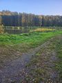
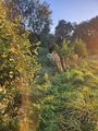
closing in
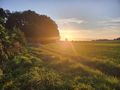
view to West with sun set
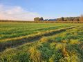
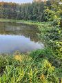
view to Northeast
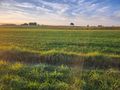
view to North
Ninja geohasher attempting the endurance hash? or just wild camping ;)
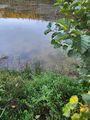
view of geohash
view of geohash #2
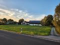
Leonberger Mühle


Achievements