Difference between revisions of "2023-10-13 40 -111"
From Geohashing
m (Location) |
m |
||
| Line 37: | Line 37: | ||
[[Category:Expeditions]] | [[Category:Expeditions]] | ||
[[Category:Expeditions with photos]] | [[Category:Expeditions with photos]] | ||
| + | [[Category:Coordinates not reached]] | ||
[[Category:Not reached - No public access]] | [[Category:Not reached - No public access]] | ||
{{location|US|UT|WA}} | {{location|US|UT|WA}} | ||
Revision as of 19:52, 18 October 2023
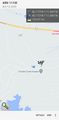
| Fri 13 Oct 2023 in 40,-111: 40.1729592, -111.0440966 geohashing.info google osm bing/os kml crox |
Location
In a residential development by Soldier Creek Bay.
Participants
Expedition
From the debacle at 2023-10-13 39 -111, I proceeded northeast and then back west to the debacle at 2023-10-13 40 -111. This hashpoint is in somebody's driveway in a development of houses overlooking a reservoir; since there's no town nearby, they are probably either vacation homes or for retirees.
Unfortunately, the area is gated, so I was thwarted 195 meters out. Phooey.
Photos
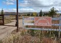
Twarted!
Phooey.

