Difference between revisions of "2023-10-13 40 -111"
From Geohashing
m |
Michael5000 (talk | contribs) (→Photos) |
||
| Line 25: | Line 25: | ||
== Photos == | == Photos == | ||
<gallery perrow="5"> | <gallery perrow="5"> | ||
| − | File:2023-10-13 40 -111 a.jpg| | + | File:2023-10-13 40 -111 a.jpg|Thwarted! |
File:2023-10-13 40 -111 b.jpg|Phooey. | File:2023-10-13 40 -111 b.jpg|Phooey. | ||
</gallery> | </gallery> | ||
Latest revision as of 14:51, 23 October 2023
| Fri 13 Oct 2023 in 40,-111: 40.1729592, -111.0440966 geohashing.info google osm bing/os kml crox |
Location
In a residential development by Soldier Creek Bay.
Participants
Expedition
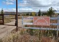
From the debacle at 2023-10-13 39 -111, I proceeded northeast and then back west to the debacle at 2023-10-13 40 -111. This hashpoint is in somebody's driveway in a development of houses overlooking a reservoir; since there's no town nearby, they are probably either vacation homes or for retirees.
Unfortunately, the area is gated, so I was thwarted 195 meters out. Phooey.
Photos
Thwarted!

Phooey.

