Difference between revisions of "2023-10-16 -37 144"
From Geohashing
Felix Dance (talk | contribs) m |
m |
||
| Line 27: | Line 27: | ||
{{bicycle geohash | {{bicycle geohash | ||
| − | | latitude = | + | | latitude = -37 |
| − | | longitude = | + | | longitude = 144 |
| date = 2023-10-16 | | date = 2023-10-16 | ||
| name = [[User:Johnwrw|John]] | | name = [[User:Johnwrw|John]] | ||
| Line 37: | Line 37: | ||
}} | }} | ||
| − | |||
[[Category:Expeditions]] | [[Category:Expeditions]] | ||
[[Category:Expeditions with photos]] | [[Category:Expeditions with photos]] | ||
[[Category:Coordinates reached]] | [[Category:Coordinates reached]] | ||
Revision as of 05:24, 26 October 2023

| Mon 16 Oct 2023 in -37,144: -37.7325861, 144.7273543 geohashing.info google osm bing/os kml crox |
Location
In Clarke Rd Streamside Reserve, on Kororoit Creek, Caroline Springs.
Participants
Expedition
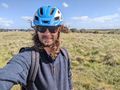
At just before 3pm, John said "I go to Caroline Springs", confusing us with his tense, arriving at 4:55pm as confirmed by his photo to the group. He was careful not to miss his plans for that evening.
Photos
Success
Achievements
John earned the Bicycle geohash achievement
|