Difference between revisions of "2023-11-10 47 -122"
From Geohashing
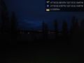
([live picture]Geohasher [https://openstreetmap.org/?mlat=47.59235150&mlon=-122.22562580&zoom=16 @47.5924,-122.2256]) |
([live picture]Looking southeast [https://openstreetmap.org/?mlat=47.59235520&mlon=-122.22560970&zoom=16 @47.5924,-122.2256]) |
||
| Line 32: | Line 32: | ||
Image:2023-11-10_47_-122_thomcat_1699665094444.jpg|Geohasher [https://openstreetmap.org/?mlat=47.59235150&mlon=-122.22562580&zoom=16 @47.5924,-122.2256] | Image:2023-11-10_47_-122_thomcat_1699665094444.jpg|Geohasher [https://openstreetmap.org/?mlat=47.59235150&mlon=-122.22562580&zoom=16 @47.5924,-122.2256] | ||
| + | |||
| + | Image:2023-11-10_47_-122_thomcat_1699665152100.jpg|Looking southeast [https://openstreetmap.org/?mlat=47.59235520&mlon=-122.22560970&zoom=16 @47.5924,-122.2256] | ||
</gallery> | </gallery> | ||
Revision as of 01:12, 11 November 2023
| Fri 10 Nov 2023 in Seattle: 47.5923558, -122.2256069 geohashing.info google osm bing/os kml crox |
Location
Near a flagpole in Luther Burbank Park, Mercer Island.
Participants
Plans
Stop by after work, aiming for 5pm.
Expedition
Tracklog
Photos
One stop first :) @47.7806,-122.1464
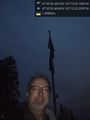
Geohasher @47.5924,-122.2256
Looking southeast @47.5924,-122.2256


