Difference between revisions of "2023-11-11 41 12"
(→Expedition) |
(gallery descriptions from the file pages, categories) |
||
| Line 37: | Line 37: | ||
--> | --> | ||
<gallery perrow="5"> | <gallery perrow="5"> | ||
| − | File:2023-11-11 41 12 start.jpg| | + | File:2023-11-11 41 12 start.jpg|A selfie from on high of my head and the handlebars of my old Brompton bicycle |
| − | File:2023-11-11 41 12 gianicolo.jpg| | + | File:2023-11-11 41 12 gianicolo.jpg|A view from near the lighthouse on the Janiculum hill, looking down towards the river Tiber, where the geohash is obscured by the trees in the foreground. |
| − | File:2023-11-11 41 12 map.jpg| | + | File:2023-11-11 41 12 map.jpg|Screenshot of my location relative to the geohash. I should note that I was not actually in the water, but at the edge. |
| − | File:2023-11-11 41 12 bike.jpg| | + | File:2023-11-11 41 12 bike.jpg|My Brompton half folded and on the edge of the river, roughly opposite the geohash, in the middle of the stream. |
| − | File:2023-11-11 41 12 track.jpg| | + | File:2023-11-11 41 12 track.jpg|A map of the route, all 5km of it (on the bicycle). You can see where I loitered near the geohash and, perhaps, where I waited for a bus up the hill. |
</gallery> | </gallery> | ||
| − | |||
| − | |||
== Achievements == | == Achievements == | ||
| Line 51: | Line 49: | ||
__NOTOC__ | __NOTOC__ | ||
| − | + | [[Category:Expeditions]] | |
| − | + | [[Category:Expeditions with photos]] | |
| − | [[Category: | + | [[Category:Coordinates not reached]] |
| − | + | [[Category:Not reached - Mother Nature]] | |
| − | + | {{location|IT|LZ}} | |
| − | |||
| − | |||
| − | [[Category: | ||
| − | |||
| − | |||
| − | |||
| − | |||
| − | |||
| − | |||
| − | |||
| − | |||
| − | |||
| − | |||
Revision as of 22:07, 13 November 2023
| Sat 11 Nov 2023 in 41,12: 41.8965614, 12.4653802 geohashing.info google osm bing/os kml crox |
Location
In the middle of the Tiber, just upstream of the Ponte Giuseppe Mazzini
Participants
Right now only me, Jeremy Cherfas, but for the first time ever I plan to be on the bridge or on the cycle path even nearer the geohash, at 4pm.
Plans
I will take the opportunity to go for a bicycle ride along the river and will be at the geohash or on the bridge at 16:00
Expedition
I got on my bike, rode for about 5 minutes to the lighthouse on the Janiculum hill, where I took a photo. Then down the hill and along the river for a few minutes to the Ponte Mazzini. I checked my location and decided I could get even closer by going down the perilous staircase to the cycle path along the edge of the Tiber. Got as close as I could to the geohash in the middle of the river and snapped a picture of the bicycle. Then treated myself to a longer ride along the cycle path to a spot where I could fold up the bike and let a bus take me home.
Tracklog
Photos
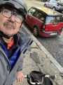
A selfie from on high of my head and the handlebars of my old Brompton bicycle
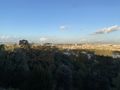
A view from near the lighthouse on the Janiculum hill, looking down towards the river Tiber, where the geohash is obscured by the trees in the foreground.
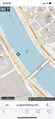
Screenshot of my location relative to the geohash. I should note that I was not actually in the water, but at the edge.
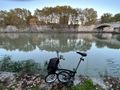
My Brompton half folded and on the edge of the river, roughly opposite the geohash, in the middle of the stream.
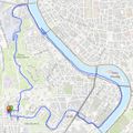
A map of the route, all 5km of it (on the bicycle). You can see where I loitered near the geohash and, perhaps, where I waited for a bus up the hill.


