Difference between revisions of "2023-12-17 63 25"
m |
|||
| Line 45: | Line 45: | ||
[[Category:Expeditions]] | [[Category:Expeditions]] | ||
| − | + | [[Category:Expeditions with photos]] | |
[[Category:Coordinates not reached]] | [[Category:Coordinates not reached]] | ||
[[Category:Not reached - Mother Nature]] | [[Category:Not reached - Mother Nature]] | ||
{{location|FI|14}} | {{location|FI|14}} | ||
Revision as of 23:23, 19 December 2023
| Sun 17 Dec 2023 in 63,25: 63.6131547, 25.9032940 geohashing.info google osm bing/os kml crox |
Location
In lake Pyhäjärvi, about 700 metres from the nearest shore.
The point on a topographic map: [1]
Participants
Expedition
I drove here after reaching 2023-12-17 63 26. I went to the fishing harbour 800 metres to the east from the hashpoint and thought I could do a nice walk to the hashpoint and back. Wrong!
While in the hilly countryside the weather had been calm and barely freezing, here there was a strong blowing wind from the lake. Already during the short walk from the parking area to the shore I started to get cold and realised I was not nearly prepared enough for walking nearly two kilometres on ice in freezing wind. I did not have enough clothes with me, and I was considerably tired, though not too tired to drive. Had it not been windy, I would likely have been able to make it.
I had already wasted enough time today, so I decided to chicken out and walked back to the car. Even then, this detour probably cost up to an hour compared to taking the direct route from the previous hashpoint to Oulu. On the way to the north I got to watch beautiful aurora borealis, which really made up for the annoyance of losing time. I wish I could have taken pictures, but I needed to focus on driving and did not want to make any more unnecessary stops. Besides, I doubt that I could even have taken very good pictures with only a crappy mobile phone camera.
Photos
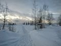
At the fishing harbour, about 900 metres to go. The headwind is not visible in the photo, but it made it too cold to continue.
