2023-12-27 39 -109
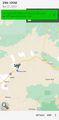
| Wed 27 Dec 2023 in 39,-109: 39.0844079, -109.1766645 geohashing.info google osm bing/os kml crox |
Location
A short climb off a BLM road, south of the I-70 Sulphur exit.
Participants
Expedition
A half hour west of Grand Junction, Colorado, we took the Sulphur exit and immediately passed a mysterious natural-resources depot of some sort with a lot of recent construction. From there, we continued 3 or 4 miles down a BLM road that paralleled the freeway for a while before wandering north into the desert.
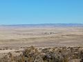
From our parking spot to the hashpoint was about 600 meters of continuous upward climb through scrubby forest, some of it along what was probably a motorbike or mountain biking path. It was a lovely morning walk on a bright, cold December day, and the views back to the north were pretty spectacular.
After walking back out, we got back on the freeway and headed west towards 2023-12-27 39 -111.
Photos
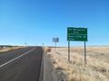
Leaving the freeway
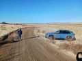
Mrs.5000 ready for the hike
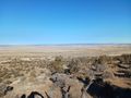
View north from the hashpoint
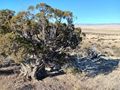
The juniper tree that lives by the hashpoint

Not the best photograph of the 5000s

But the hashcot always looks dapper
The industrial depot, off in the distance


Achievements