Difference between revisions of "2024-01-01 51 13"
([live picture]Erfolgreicher Besuch (naja, bis auf gut 4m)) |
(report) |
||
| Line 1: | Line 1: | ||
| − | + | {{meetup graticule | |
| − | |||
| − | |||
| − | |||
| − | |||
| − | |||
| − | |||
| − | |||
| − | |||
| lat=51 | | lat=51 | ||
| lon=13 | | lon=13 | ||
| date=2024-01-01 | | date=2024-01-01 | ||
| − | }} | + | }} |
| + | |||
== Location == | == Location == | ||
| − | + | In the front yard of a residential road in the Niedersedlitz part of Dresden. | |
== Participants == | == Participants == | ||
| − | + | - [[User:Oisín|Oisín]] ([[User talk:Oisín|talk]]) | |
| − | |||
== Plans == | == Plans == | ||
| − | + | Visit the hash by bike in the afternoon. | |
== Expedition == | == Expedition == | ||
| − | + | To celebrate the beginning of the bicycle season 2024 I decided to go for a little tour to the south of the city passing by the hash location. The way to the hash was fairly straight forward as most of the route was known to me. I only had to take out the map for the last 2 km. The exact coordinates were located just a little inside the front yards of the houses. The footpath is fairly wide here so I parked my bike as close to the hash as I could. The closest I could get was about 4m with should be okay to claim the hash as reached. | |
| + | |||
| + | Additionally this is an accidental déjà-vu for me as I passed this street already during a bike tour on Juli 13 last year. | ||
== Tracklog == | == Tracklog == | ||
| Line 34: | Line 28: | ||
<gallery perrow="5"> | <gallery perrow="5"> | ||
| − | Image:2024-01-01_51_13_Oisín_1704125619036.jpg| | + | Image:2024-01-01_51_13_Oisín_1704125619036.jpg|Grin at the hash (okay, it's 4m off) |
</gallery> | </gallery> | ||
| Line 42: | Line 36: | ||
__NOTOC__ | __NOTOC__ | ||
| − | |||
| − | |||
| − | |||
| − | |||
| − | |||
| − | |||
| − | |||
| − | |||
| − | |||
| − | |||
| − | |||
| − | |||
| − | |||
[[Category:Expeditions]] | [[Category:Expeditions]] | ||
| − | |||
[[Category:Expeditions with photos]] | [[Category:Expeditions with photos]] | ||
| − | |||
| − | |||
| − | |||
| − | |||
[[Category:Coordinates reached]] | [[Category:Coordinates reached]] | ||
| − | |||
| − | |||
| − | |||
| − | |||
| − | |||
| − | |||
| − | |||
| − | |||
| − | |||
| − | |||
| − | |||
| − | |||
| − | |||
| − | |||
| − | |||
| − | |||
| − | |||
| − | |||
Revision as of 13:56, 2 January 2024
| Mon 1 Jan 2024 in 51,13: 51.0001178, 13.8192533 geohashing.info google osm bing/os kml crox |
Location
In the front yard of a residential road in the Niedersedlitz part of Dresden.
Participants
Plans
Visit the hash by bike in the afternoon.
Expedition
To celebrate the beginning of the bicycle season 2024 I decided to go for a little tour to the south of the city passing by the hash location. The way to the hash was fairly straight forward as most of the route was known to me. I only had to take out the map for the last 2 km. The exact coordinates were located just a little inside the front yards of the houses. The footpath is fairly wide here so I parked my bike as close to the hash as I could. The closest I could get was about 4m with should be okay to claim the hash as reached.
Additionally this is an accidental déjà-vu for me as I passed this street already during a bike tour on Juli 13 last year.
Tracklog
Photos
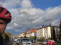
Grin at the hash (okay, it's 4m off)
