Difference between revisions of "2024-01-12 49 8"
Gefrierbrand (talk | contribs) ([retro picture]proof) |
Gefrierbrand (talk | contribs) |
||
| Line 1: | Line 1: | ||
| − | + | {{meetup graticule | |
| − | |||
| − | |||
| − | |||
| − | |||
| − | |||
| − | |||
| − | |||
| − | |||
| lat=49 | | lat=49 | ||
| lon=8 | | lon=8 | ||
| date=2024-01-12 | | date=2024-01-12 | ||
| − | }} | + | }} |
== Location == | == Location == | ||
| − | + | In a forest near Ober-Ramstadt | |
== Participants == | == Participants == | ||
| − | + | *[[User:Gefrierbrand|Gefrierbrand]] | |
| − | + | *[[User:Santu|Santu]] | |
| + | *Pedro the dog | ||
== Plans == | == Plans == | ||
| − | + | Visit family by bus, take another bus from there to get near the hash and walk home in the dark using a lantern as lightsource. | |
== Expedition == | == Expedition == | ||
| − | + | Pretty much as planned. We took the bus and got our lantern from the backpack unsure whether it would a) be bright enough and b) stay lit even while being shaken around as we walked. Surprisingly, we had absolutely no issues with the candle and it provided enough light to at least see the contours of our immediate surroundings. The clouds on the sky also reflected some light of nearby towns and a thin layer of snow also sometimes helped to make out the way. | |
| + | |||
| + | As we neared the hash we had to enter a forest, which is where things got interesting. As it is often the case, the path indicated on google maps was nowhere to be found and the ground was littered with broken tree branches and other random shrubbery. While we tried to get around the bigger stuff and not getting hit in the face by small virtually invisible twigs, Pedro had apparently no issues at all and rummaged happily around and even managed to not tangle up his towing leash. | ||
| + | |||
| + | Fortunately, we didn't have to venture too far of the path and found the hashlocation relatively easily. We took a short break and put the lantern on a fallen tree to take the required stupid grin photo. We then started our walk home, mane another short stop to drink some hot tea in the shine of our lantern a bit later and finally quickly got to bead after reaching our home later that night. | ||
== Tracklog == | == Tracklog == | ||
| − | + | {{tracklog | T2024-01-12-21-51gh.gpx}} | |
| − | |||
== Photos == | == Photos == | ||
| − | |||
| − | |||
| − | |||
<gallery perrow="5"> | <gallery perrow="5"> | ||
| − | + | Image:2024-01-12_49_8_Gefrierbrand_1705138328907.jpg|Santu being illuminated by our lantern | |
| − | Image:2024-01-12_49_8_Gefrierbrand_1705138328907.jpg| | + | Image:2024-01-12_49_8_Gefrierbrand_1705138357463.jpg|StupidGrin<sup>TM</sup> |
| − | + | Image:2024-01-12_49_8_Gefrierbrand_1705138395508.jpg|Warm tea in the dark | |
| − | Image:2024-01-12_49_8_Gefrierbrand_1705138357463.jpg| | ||
| − | |||
| − | Image:2024-01-12_49_8_Gefrierbrand_1705138395508.jpg| | ||
| − | |||
Image:2024-01-12_49_8_Gefrierbrand_1705138432919.jpg|proof | Image:2024-01-12_49_8_Gefrierbrand_1705138432919.jpg|proof | ||
</gallery> | </gallery> | ||
| Line 45: | Line 34: | ||
== Achievements == | == Achievements == | ||
{{#vardefine:ribbonwidth|100%}} | {{#vardefine:ribbonwidth|100%}} | ||
| − | + | {{land geohash | |
| + | | latitude = 49 | ||
| + | | longitude = 8 | ||
| + | | date = 2024-01-12 | ||
| + | | name = Gefrierbrand & Santu | ||
| + | }} | ||
| + | {{Public transport geohash | ||
| + | | latitude = 49 | ||
| + | | longitude = 8 | ||
| + | | date = 2024-01-12 | ||
| + | | name = Gefrierbrand & Santu | ||
| + | | busline = NR & O | ||
| + | }} | ||
| + | {{gratuitous ribbon | ||
| + | | color = #ff8f00 | ||
| + | | icon = Halloween_geohash.gif | ||
| + | | latitude = 49 | ||
| + | | longitude = 8 | ||
| + | | date = 2024-01-12 | ||
| + | | name = Gefrierbrand & Santu | ||
| + | | achievement = Candle-Light Achievement | ||
| + | | description = reaching the geohash in the dark and illuminating it with a candle-powered lantern. | ||
| + | }} | ||
__NOTOC__ | __NOTOC__ | ||
| − | |||
| − | |||
| − | |||
| − | |||
| − | |||
| − | |||
| − | |||
| − | |||
| − | |||
| − | |||
| − | |||
| − | |||
| − | |||
[[Category:Expeditions]] | [[Category:Expeditions]] | ||
| − | |||
[[Category:Expeditions with photos]] | [[Category:Expeditions with photos]] | ||
| − | |||
| − | |||
| − | |||
| − | |||
| − | |||
[[Category:Coordinates reached]] | [[Category:Coordinates reached]] | ||
| − | |||
| − | |||
| − | |||
| − | |||
| − | |||
| − | |||
| − | |||
| − | |||
| − | |||
| − | |||
| − | |||
| − | |||
| − | |||
| − | |||
| − | |||
| − | |||
| − | |||
| − | |||
Revision as of 12:34, 13 January 2024
| Fri 12 Jan 2024 in 49,8: 49.8131277, 8.7481457 geohashing.info google osm bing/os kml crox |
Location
In a forest near Ober-Ramstadt
Participants
- Gefrierbrand
- Santu
- Pedro the dog
Plans
Visit family by bus, take another bus from there to get near the hash and walk home in the dark using a lantern as lightsource.
Expedition
Pretty much as planned. We took the bus and got our lantern from the backpack unsure whether it would a) be bright enough and b) stay lit even while being shaken around as we walked. Surprisingly, we had absolutely no issues with the candle and it provided enough light to at least see the contours of our immediate surroundings. The clouds on the sky also reflected some light of nearby towns and a thin layer of snow also sometimes helped to make out the way.
As we neared the hash we had to enter a forest, which is where things got interesting. As it is often the case, the path indicated on google maps was nowhere to be found and the ground was littered with broken tree branches and other random shrubbery. While we tried to get around the bigger stuff and not getting hit in the face by small virtually invisible twigs, Pedro had apparently no issues at all and rummaged happily around and even managed to not tangle up his towing leash.
Fortunately, we didn't have to venture too far of the path and found the hashlocation relatively easily. We took a short break and put the lantern on a fallen tree to take the required stupid grin photo. We then started our walk home, mane another short stop to drink some hot tea in the shine of our lantern a bit later and finally quickly got to bead after reaching our home later that night.
Tracklog
Photos
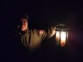
Santu being illuminated by our lantern
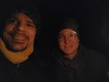
StupidGrinTM
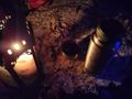
Warm tea in the dark
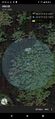
proof


Achievements
Gefrierbrand & Santu earned the Land geohash achievement
|
Gefrierbrand & Santu earned the Public transport geohash achievement
|
Gefrierbrand & Santu earned the Candle-Light Achievement
|