Difference between revisions of "2024-01-22 32 35"
Yerushalmi (talk | contribs) (Created page with "{{subst:Expedition}}") |
Yerushalmi (talk | contribs) |
||
| Line 13: | Line 13: | ||
}}<!-- edit as necessary --> | }}<!-- edit as necessary --> | ||
== Location == | == Location == | ||
| − | + | On barren land outside of Kibbutz Dalia, just off of a path that goes near the sewage treatment plant. Smells fun! | |
== Participants == | == Participants == | ||
| − | + | [[User:Yerushalmi|Yerushalmi]] ([[User talk:Yerushalmi|talk]]) | |
| − | |||
== Plans == | == Plans == | ||
| − | + | Train to Tel Aviv, train to Haifa, drop off my wife's artwork at a gallery there, train to Yokneam, bus to Dalia, walk to the point. | |
== Expedition == | == Expedition == | ||
| − | + | Travel to the point went pretty much without a hitch. I got on the 08:39 train, davened Shacharit, switched trains at Hashalom station, got off at the Merkaz Hashmona train station in Haifa, walked to the gallery, dropped off the painting, walked back to the train station and took the train to Yokneam. | |
| − | + | I had an hour to kill before the bus arrived so I did Daf Yomi and ate lunch. The bus took a long time to get to Kibbutz Dalia but the trip was uneventful, as was the walk to the point. It was a pleasant walk and some beautiful scenery. The only snag was when a dog started barking at me; just in case I took my smooth throwing-rock out of its pocket and picked up another rock off the ground. Then when I left the dog I discarded one rock and put the other back in the pocket - discovering later that I had switched them by accident. I'll have to find a new good throwing rock. | |
| − | |||
| − | + | I had printed out maps and decided to challenge myself to get to the field with the point without GPS, which I did successfully, using GPS only to figure out where in the field the actual point was. (There was no noticeable smell from the sewage treatment plant.) The field had some interesting really dense spiderwebs with, in some cases, massive numbers of centipedes crawling on them: | |
| − | + | ||
| − | + | [[File:20240122_134244.jpg|400px]] | |
| − | + | ||
| − | + | I've been having a difficult few months, so when I reached the point I laid my backpack on the ground at the point and lied down on top of it for about a half hour. It was peaceful and pleasant. | |
| − | |||
| − | + | Eventually I got up; I had 29 minutes to get to a bus stop 26 minutes' walk away, in kibbutz Ramot Menashe. Shouldn't be too difficult. | |
| − | |||
| − | |||
| − | + | On the way I saw this sign and lost one of my three minutes laughing my head off: | |
| − | |||
| − | |||
| − | |||
| − | + | [[File:20240122_141833.jpg|400px]] | |
| − | + | About 100m later, I discovered that the path I was supposed to take was labeled no entrance, private property - with a detour sign to a longer path. This longer path was pretty fun, going right through an active herd of grazing cows and their bird friends (seriously), but it also delayed me long enough that even with walking faster I missed the bus by less than a minute. So it was the sign's fault after all. | |
| − | |||
| − | |||
| − | |||
| − | + | The next bus wouldn't be for two hours. Time for plan B: hitchhiking. My first hitchhike took me the intersection outside the kibbutz, and my second took me all the way to the train station in Binyamina. | |
| − | + | During the second hitchhike, being a longer portion of the route, I got to know Ofir, who owns a farm with 40,000 chickens that lay the eggs that grow up to be the chickens that we eat. He doesn't grow chickens that we eat, nor does he sell the eggs to the farms that grow the chickens that we eat; he sells the eggs to the incubating forms that hatch the chickens which are then sold to the farms that grow them and then we eat them. Each of those chickens is worth thousands of dollars. | |
| − | |||
| − | |||
| − | |||
| − | |||
| − | |||
| − | |||
| − | |||
| − | |||
| − | |||
| + | He also by coincidence from Kibbutz Dalia (though he no longer lives there - he just happened to be driving by) and had a healthy interest in geography, so when I explained geohashing to him he was able to quickly figure out where today's point was and name the river that was nearby. At the train station I got out and his son, who had just returned from the front in Gaza, got in. | ||
| − | + | From the Binyamina train station, simple train ride to Ben Gurion Airport, then switched trains to go to Jerusalem. | |
| − | |||
| − | |||
| − | |||
| − | |||
| − | |||
| − | |||
| − | |||
| − | + | == Photos == | |
| − | + | <gallery> | |
| − | + | File:20240122_131059.jpg | Some kind of swampy bit | |
| − | + | File:20240122_131104.jpg | The road ahead | |
| − | + | File:20240122_131253.jpg | Entrance sign to a nature reserve | |
| + | File:20240122_131732.jpg | You never want to drawn in sewage | ||
| + | File:20240122_131855.jpg | Centipedes on a spiderweb | ||
| + | File:20240122_131951.jpg | Field with red and purple flowers | ||
| + | File:Screenshot_20240122_132106_Geohash Droid.jpg | Proof | ||
| + | File:20240122_132122.jpg | Panorama at the point | ||
| + | File:20240122_134244.jpg | LOTS of centipedes on a spiderweb | ||
| + | File:20240122_141645.jpg | Flock of birds | ||
| + | File:20240122_141700.jpg | Same flock of birds | ||
| + | File:20240122_141733.jpg | Cows and birds at a distance | ||
| + | File:20240122_141753.jpg | Cows and birds at a distance, zoomed-in | ||
| + | File:20240122_141833.jpg | Entrance to the Tomb of Horrors | ||
| + | File:20240122_141908.jpg | Field with red, purple, and yellow flowers | ||
| + | File:20240122_142103.jpg | River crossing | ||
| + | File:20240122_142706.jpg | Cows close up | ||
| + | File:20240122_142713.jpg | Cows and birds close up | ||
| + | </gallery> | ||
| − | + | [[Category:Expeditions]] | |
| + | [[Category:Expeditions with photos]] | ||
| + | [[Category:Coordinates reached]] | ||
Revision as of 16:26, 22 January 2024
| Mon 22 Jan 2024 in 32,35: 32.5835069, 35.0643792 geohashing.info google osm bing/os kml crox |
Contents
Location
On barren land outside of Kibbutz Dalia, just off of a path that goes near the sewage treatment plant. Smells fun!
Participants
Plans
Train to Tel Aviv, train to Haifa, drop off my wife's artwork at a gallery there, train to Yokneam, bus to Dalia, walk to the point.
Expedition
Travel to the point went pretty much without a hitch. I got on the 08:39 train, davened Shacharit, switched trains at Hashalom station, got off at the Merkaz Hashmona train station in Haifa, walked to the gallery, dropped off the painting, walked back to the train station and took the train to Yokneam.
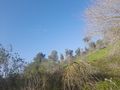
I had an hour to kill before the bus arrived so I did Daf Yomi and ate lunch. The bus took a long time to get to Kibbutz Dalia but the trip was uneventful, as was the walk to the point. It was a pleasant walk and some beautiful scenery. The only snag was when a dog started barking at me; just in case I took my smooth throwing-rock out of its pocket and picked up another rock off the ground. Then when I left the dog I discarded one rock and put the other back in the pocket - discovering later that I had switched them by accident. I'll have to find a new good throwing rock.
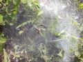
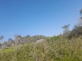
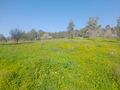
I had printed out maps and decided to challenge myself to get to the field with the point without GPS, which I did successfully, using GPS only to figure out where in the field the actual point was. (There was no noticeable smell from the sewage treatment plant.) The field had some interesting really dense spiderwebs with, in some cases, massive numbers of centipedes crawling on them:

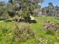
I've been having a difficult few months, so when I reached the point I laid my backpack on the ground at the point and lied down on top of it for about a half hour. It was peaceful and pleasant.
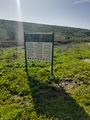
Eventually I got up; I had 29 minutes to get to a bus stop 26 minutes' walk away, in kibbutz Ramot Menashe. Shouldn't be too difficult.
On the way I saw this sign and lost one of my three minutes laughing my head off:

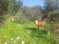
About 100m later, I discovered that the path I was supposed to take was labeled no entrance, private property - with a detour sign to a longer path. This longer path was pretty fun, going right through an active herd of grazing cows and their bird friends (seriously), but it also delayed me long enough that even with walking faster I missed the bus by less than a minute. So it was the sign's fault after all.
The next bus wouldn't be for two hours. Time for plan B: hitchhiking. My first hitchhike took me the intersection outside the kibbutz, and my second took me all the way to the train station in Binyamina.
During the second hitchhike, being a longer portion of the route, I got to know Ofir, who owns a farm with 40,000 chickens that lay the eggs that grow up to be the chickens that we eat. He doesn't grow chickens that we eat, nor does he sell the eggs to the farms that grow the chickens that we eat; he sells the eggs to the incubating forms that hatch the chickens which are then sold to the farms that grow them and then we eat them. Each of those chickens is worth thousands of dollars.
He also by coincidence from Kibbutz Dalia (though he no longer lives there - he just happened to be driving by) and had a healthy interest in geography, so when I explained geohashing to him he was able to quickly figure out where today's point was and name the river that was nearby. At the train station I got out and his son, who had just returned from the front in Gaza, got in.
From the Binyamina train station, simple train ride to Ben Gurion Airport, then switched trains to go to Jerusalem.
Photos
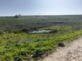
Some kind of swampy bit
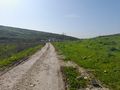
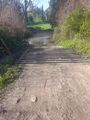
The road ahead
Entrance sign to a nature reserve
You never want to drawn in sewage
Centipedes on a spiderweb
Field with red and purple flowers

Proof
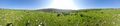
Panorama at the point
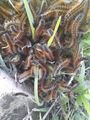
LOTS of centipedes on a spiderweb
Flock of birds
Same flock of birds
Cows and birds at a distance

Cows and birds at a distance, zoomed-in
Entrance to the Tomb of Horrors
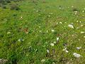
Field with red, purple, and yellow flowers
River crossing
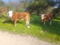
Cows close up
Cows and birds close up


