Difference between revisions of "2024-02-03 32 -96"
(full report) |
(categories) |
||
| Line 54: | Line 54: | ||
__NOTOC__ | __NOTOC__ | ||
| − | |||
| − | |||
| − | |||
| − | |||
| − | |||
| − | |||
| − | |||
| − | |||
| − | |||
| − | |||
| − | |||
| − | |||
| − | |||
| − | |||
[[Category:Expeditions]] | [[Category:Expeditions]] | ||
| − | |||
[[Category:Expeditions with photos]] | [[Category:Expeditions with photos]] | ||
| − | |||
| − | |||
| − | |||
| − | |||
| − | |||
[[Category:Coordinates reached]] | [[Category:Coordinates reached]] | ||
| − | |||
| − | |||
| − | |||
| − | |||
| − | |||
| − | |||
| − | |||
| − | |||
| − | |||
| − | |||
| − | |||
| − | |||
| − | |||
| − | |||
| − | |||
| − | |||
| − | |||
| − | |||
Revision as of 03:53, 8 February 2024
| Sat 3 Feb 2024 in 32,-96: 32.8656057, -96.8825541 geohashing.info google osm bing/os kml crox |
Location
Behind a NAPA Auto Parts store in Northwest Dallas, TX.
what3words: ///bound.this.trim (what is this?)
Participants
Plans
Luke planned a route the day before, which would involve the train and a very long run.
Expedition
Luke took the 8:31am DART Red Line south from Downtown Plano Station to Forest Lane Station. From Forest Lane Station, he ran west mainly along the Northhaven Trail. It was cloudy and mild. A little after 10 miles (16 km), Luke reached the NAPA Auto Parts store and quickly ran behind it to reach the hash, trying to look inconspicuous or possibly lost. With proof recorded and a selfie in front of the store, Luke continued on his run, heading to SMU/Mockingbird Station via University Blvd and the SMU campus. Along the run back, he visited the grave of Bonnie Parker of "Bonnie and Clyde" infamy. In total, the run was 19 miles (30.5 km). He took the Red Line back to Downtown Plano, arriving back home around 1:45pm.
Tracklog
Photos
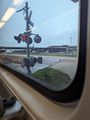
View from the train
Proof

Stupid grin™
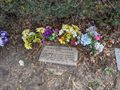
Bonnie Parker's grave


