Difference between revisions of "2024-02-05 31 34"
Yerushalmi (talk | contribs) (Created page with "{{subst:Expedition}}") |
Yerushalmi (talk | contribs) |
||
| Line 13: | Line 13: | ||
}}<!-- edit as necessary --> | }}<!-- edit as necessary --> | ||
== Location == | == Location == | ||
| − | + | In an orchard of pecan trees east of Ashkelon. | |
== Participants == | == Participants == | ||
| − | + | [[User:Yerushalmi|Yerushalmi]] ([[User talk:Yerushalmi|talk]]) | |
| − | |||
== Plans == | == Plans == | ||
| − | + | Train to Tel Aviv, train to Ashkelon. Bus to the nearest town, Kochav Michael. Walk between the fields for 45 minutes until I reach the point. Then check bus routes for the way back. | |
== Expedition == | == Expedition == | ||
| − | + | For the most part the expedition went as planned. Trains are trains and went as expected. I had an amusing moment on the bus: it went through all of the streets in Kochav Michael, past stop after stop, dropping people off, and then as it left I signalled to the driver that I want to get out at the stop on the highway just outside the town. He looked at me like I was insane: Why didn't you get off in the town? I told him I wasn't going to the town. So he looked at me like I was even more insane. | |
| + | |||
| + | The walk to the point was pleasant and uneventful. At one point I sat down to eat lunch. At another point I discovered that part of the path I was walking on was actually an official trail called "the path of light". | ||
| + | |||
| + | I walked to the orchard, walked to the point, and walked back to the bus stop. On the way I noticed a glitch in Planet Earth's graphics rendering: | ||
| + | [[:File:20240205_150624.mp4]] | ||
| − | + | I filed a bug report with God. | |
| − | + | ||
| + | The route home was essentially the reverse of the route there. | ||
== Photos == | == Photos == | ||
| Line 32: | Line 37: | ||
Image:2020-##-## ## ## Alpha.jpg | Witty Comment | Image:2020-##-## ## ## Alpha.jpg | Witty Comment | ||
--> | --> | ||
| − | <gallery | + | <gallery> |
| + | File:20240205_131654.jpg | The bus stop outside Kochav Michael, which the driver was so shocked I wanted to get out at. | ||
| + | File:20240205_132632.jpg | Panorama not at the point - there was a small ridge in the path and the view was amazing. | ||
| + | File:20240205_132846.jpg | A stream went directly under this road - you can see it snaking through the fields on the left, and the opening to the culvert on the right. | ||
| + | File:20240205_132938.jpg | Almost painting-like | ||
| + | File:20240205_133343.jpg | More great views | ||
| + | File:20240205_134908.jpg | A weird natural valley-quarry-thing | ||
| + | File:20240205_135247.jpg | I'm walking the Path of Light! | ||
| + | File:20240205_142502.jpg | A the point, drawing of xkcd in the mud with the edge of my boot | ||
| + | File:20240205_142512.jpg | Panorama at the point | ||
| + | File:Screenshot_20240205_142404_Geohash Droid.jpg | Proof | ||
</gallery> | </gallery> | ||
| − | |||
| − | |||
| − | |||
| − | |||
| − | |||
| − | |||
| − | |||
| − | |||
| − | |||
| − | |||
| − | |||
| − | |||
| − | |||
| − | |||
| − | |||
| − | |||
| − | |||
| − | |||
[[Category:Expeditions]] | [[Category:Expeditions]] | ||
| − | |||
[[Category:Expeditions with photos]] | [[Category:Expeditions with photos]] | ||
[[Category:Expeditions with videos]] | [[Category:Expeditions with videos]] | ||
| − | |||
| − | |||
| − | |||
| − | |||
[[Category:Coordinates reached]] | [[Category:Coordinates reached]] | ||
| − | |||
| − | |||
| − | |||
| − | |||
| − | |||
| − | |||
| − | |||
| − | |||
| − | |||
| − | |||
| − | |||
| − | |||
| − | |||
| − | |||
| − | |||
| − | |||
| − | |||
| − | |||
Revision as of 12:07, 7 February 2024
| Mon 5 Feb 2024 in 31,34: 31.6268179, 34.6396587 geohashing.info google osm bing/os kml crox |
Contents
Location
In an orchard of pecan trees east of Ashkelon.
Participants
Plans
Train to Tel Aviv, train to Ashkelon. Bus to the nearest town, Kochav Michael. Walk between the fields for 45 minutes until I reach the point. Then check bus routes for the way back.
Expedition
For the most part the expedition went as planned. Trains are trains and went as expected. I had an amusing moment on the bus: it went through all of the streets in Kochav Michael, past stop after stop, dropping people off, and then as it left I signalled to the driver that I want to get out at the stop on the highway just outside the town. He looked at me like I was insane: Why didn't you get off in the town? I told him I wasn't going to the town. So he looked at me like I was even more insane.
The walk to the point was pleasant and uneventful. At one point I sat down to eat lunch. At another point I discovered that part of the path I was walking on was actually an official trail called "the path of light".
I walked to the orchard, walked to the point, and walked back to the bus stop. On the way I noticed a glitch in Planet Earth's graphics rendering: File:20240205_150624.mp4
I filed a bug report with God.
The route home was essentially the reverse of the route there.
Photos
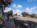
The bus stop outside Kochav Michael, which the driver was so shocked I wanted to get out at.
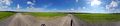
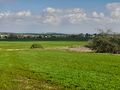
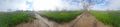
Panorama not at the point - there was a small ridge in the path and the view was amazing.
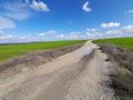
A stream went directly under this road - you can see it snaking through the fields on the left, and the opening to the culvert on the right.
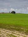
Almost painting-like
More great views
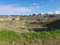
A weird natural valley-quarry-thing
I'm walking the Path of Light!
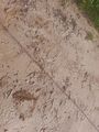
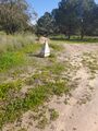
A the point, drawing of xkcd in the mud with the edge of my boot
Panorama at the point
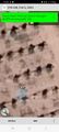
Proof


