Difference between revisions of "2024-02-10 47 -122"
From Geohashing
([live picture]Pre-func Spud [https://openstreetmap.org/?mlat=47.67831300&mlon=-122.32700900&zoom=16 @47.6783,-122.3270]) |
Coyotebush (talk | contribs) ([live] Looks promising but don't want to disturb the neighbors more than necessary for the meetup) |
||
| Line 22: | Line 22: | ||
<!-- how it all turned out. your narrative goes here. --> | <!-- how it all turned out. your narrative goes here. --> | ||
| + | |||
| + | *Looks promising but don't want to disturb the neighbors more than necessary for the meetup -- [[User:Coyotebush|Coyotebush]] ([[User talk:Coyotebush|talk]]) [https://openstreetmap.org/?mlat=47.72153399&mlon=-122.33583372&zoom=16 @47.7215,-122.3358] 15:50, 10 February 2024 (PST) | ||
== Tracklog == | == Tracklog == | ||
<!-- if your GPS device keeps a log, you may use Template:Tracklog, post a link here, or both --> | <!-- if your GPS device keeps a log, you may use Template:Tracklog, post a link here, or both --> | ||
Revision as of 23:50, 10 February 2024
| Sat 10 Feb 2024 in Seattle: 47.7210372, -122.3353634 geohashing.info google osm bing/os kml crox |
Location
A semi-private drive next to Haller Lake.
Participants
Plans
Bike there. 4pm per convention, or another time for a meetup. Coyotebush (talk) 16:53, 10 February 2024 (UTC)
Driving due to other commitments. 4pm perfect. --Thomcat (talk)
Expedition
- Looks promising but don't want to disturb the neighbors more than necessary for the meetup -- Coyotebush (talk) @47.7215,-122.3358 15:50, 10 February 2024 (PST)
Tracklog
Photos
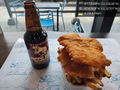
Pre-func Spud @47.6783,-122.3270

Achievements