Difference between revisions of "2024-02-25 31 34"
Yerushalmi (talk | contribs) (Created page with "{{subst:Expedition}}") |
m (Location) |
||
| (2 intermediate revisions by 2 users not shown) | |||
| Line 13: | Line 13: | ||
}}<!-- edit as necessary --> | }}<!-- edit as necessary --> | ||
== Location == | == Location == | ||
| − | + | A field outside the town of Ben Zakkai, which is right next to Yavne. This late in the winter it will probably be full of crops, so I doubt it'll be accessible. | |
== Participants == | == Participants == | ||
| − | + | [[User:Yerushalmi|Yerushalmi]] ([[User talk:Yerushalmi|talk]]) | |
| − | |||
== Plans == | == Plans == | ||
| − | + | Train to Tel Aviv, drop off my wife's artwork at a gallery, train to Yavne, go to the field, discover I can't go to the point, come home. That's the plan. | |
== Expedition == | == Expedition == | ||
| − | + | Train to Tel Aviv and dropping off my wife's artwork went as expected. To understand what happens next, I need to explain that there are two train lines from Tel Aviv that go through Yavne: one to the east and one to the west. Both train lines go to Ashdod afterwards. I needed the Yavne East train station, but the most convenient train from the area of the art gallery went to Yavne West. Moovit recommended I take the train through Yavne West to Ashdod, wait three minutes, and take a train back north from Ashdod to Yavne East. | |
| − | + | I reached Ashdod with no trouble, but then came my mistake: the two northbound trains were scheduled very close to one another and I got on the wrong one, finding myself back in Yavne West. | |
| − | + | ||
| + | This was a recoverable error. I took a bus across Yavne to the southern edge, where I would need to walk across into Ben Zakkai. I've been challenging myself more lately to use printed maps, so I headed south after the bus stop - but then I realized I went too far south, past all the roads that crossed the creek, and I would need to cross it myself. | ||
| + | |||
| + | Luckily, however, the creek was not only very low, but the denizens of Yavne and Ben Zakkai provided a nice little makeshift bridge out of rubbish: | ||
| + | |||
| + | [[File:20240225_152042.jpg|400px]] | ||
| + | |||
| + | From there it was a brisk walk through Ben Zakkai to the field, which was, as expected, covered with crops: | ||
| + | [[File:20240225_154803.jpg|400px]] | ||
| + | |||
| + | You might be able to see a sort of golf cart in the distance of that photo. When I first got to the field, there was a man in it, then he walked off to the left behind the bushes there. I didn't call out to him because I wasn't sure what field I'd need to enter - and by the time I realized it was this field, he was gone. The field had these furrows in it, presumably from similar golf carts, which implied I could walk to the point if I chose the correct already-trampled row. But I wasn't going to do it without permission. | ||
| + | |||
| + | I checked how long I had until the next train, and as a result was able to wait around for about half an hour, but he didn't return. So I accepted the No Trespassing consolation prize and went home. | ||
| + | |||
| + | On the way home I discovered I had left my jacket somewhere along the way, which is depressing. | ||
== Photos == | == Photos == | ||
| − | < | + | <gallery> |
| − | + | File:20240225_152042.jpg | A river crossing | |
| − | + | File:20240225_153329.jpg | I saw a bird | |
| − | + | File:20240225_154803.jpg | Crops | |
</gallery> | </gallery> | ||
== Achievements == | == Achievements == | ||
{{#vardefine:ribbonwidth|100%}} | {{#vardefine:ribbonwidth|100%}} | ||
| − | + | {{No trespassing | |
| − | + | | latitude = 31 | |
| − | + | | longitude = 34 | |
| − | + | | date = 2024-02-25 | |
| − | + | | name = Yerushalmi | |
| + | | image = 20240225_154803.jpg | ||
| + | | distance = 200 meters | ||
| − | + | }} | |
| − | + | __NOTOC__ | |
| − | |||
| − | |||
| − | |||
| − | |||
| − | |||
| − | |||
| − | |||
[[Category:Expeditions]] | [[Category:Expeditions]] | ||
| − | |||
[[Category:Expeditions with photos]] | [[Category:Expeditions with photos]] | ||
| − | |||
| − | |||
| − | |||
| − | |||
| − | |||
| − | |||
| − | |||
| − | |||
| − | |||
[[Category:Coordinates not reached]] | [[Category:Coordinates not reached]] | ||
| − | |||
| − | |||
| − | |||
| − | |||
| − | |||
[[Category:Not reached - No public access]] | [[Category:Not reached - No public access]] | ||
| − | + | {{location|IL|M|RH}} | |
| − | |||
| − | |||
| − | |||
| − | |||
| − | |||
| − | |||
| − | |||
Latest revision as of 12:44, 1 March 2024
| Sun 25 Feb 2024 in 31,34: 31.8523079, 34.7234192 geohashing.info google osm bing/os kml crox |
Location
A field outside the town of Ben Zakkai, which is right next to Yavne. This late in the winter it will probably be full of crops, so I doubt it'll be accessible.
Participants
Plans
Train to Tel Aviv, drop off my wife's artwork at a gallery, train to Yavne, go to the field, discover I can't go to the point, come home. That's the plan.
Expedition
Train to Tel Aviv and dropping off my wife's artwork went as expected. To understand what happens next, I need to explain that there are two train lines from Tel Aviv that go through Yavne: one to the east and one to the west. Both train lines go to Ashdod afterwards. I needed the Yavne East train station, but the most convenient train from the area of the art gallery went to Yavne West. Moovit recommended I take the train through Yavne West to Ashdod, wait three minutes, and take a train back north from Ashdod to Yavne East.
I reached Ashdod with no trouble, but then came my mistake: the two northbound trains were scheduled very close to one another and I got on the wrong one, finding myself back in Yavne West.
This was a recoverable error. I took a bus across Yavne to the southern edge, where I would need to walk across into Ben Zakkai. I've been challenging myself more lately to use printed maps, so I headed south after the bus stop - but then I realized I went too far south, past all the roads that crossed the creek, and I would need to cross it myself.
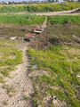
Luckily, however, the creek was not only very low, but the denizens of Yavne and Ben Zakkai provided a nice little makeshift bridge out of rubbish:

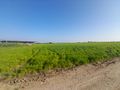
From there it was a brisk walk through Ben Zakkai to the field, which was, as expected, covered with crops:

You might be able to see a sort of golf cart in the distance of that photo. When I first got to the field, there was a man in it, then he walked off to the left behind the bushes there. I didn't call out to him because I wasn't sure what field I'd need to enter - and by the time I realized it was this field, he was gone. The field had these furrows in it, presumably from similar golf carts, which implied I could walk to the point if I chose the correct already-trampled row. But I wasn't going to do it without permission.
I checked how long I had until the next train, and as a result was able to wait around for about half an hour, but he didn't return. So I accepted the No Trespassing consolation prize and went home.
On the way home I discovered I had left my jacket somewhere along the way, which is depressing.
Photos
A river crossing
I saw a bird
Crops

Achievements
Yerushalmi earned the No trespassing consolation prize
|