Difference between revisions of "2024-02-29 53 10"
([retro picture]Callback to four years ago) |
(p-rep) |
||
| Line 1: | Line 1: | ||
| − | + | {{meetup graticule | |
| + | | lat={{#explode:{{SUBPAGENAME}}| |1}} | ||
| + | | lon={{#explode:{{SUBPAGENAME}}| |2}} | ||
| + | | date={{#explode:{{SUBPAGENAME}}| |0}} | ||
| + | }} | ||
| − | + | ==Location== | |
| + | in a garden in Hartenholn, Schleswig-Holstein | ||
| − | + | ==Participants== | |
| − | + | *[[User:π π π|π π π]] ([[User talk:π π π|talk]]) | |
| − | + | ==Expedition== | |
| − | + | Leap hash! I couldn't let this opportunity slip by, especially considering the lengths I went to get to to reach the hash four years ago (yes, I know I still haven't written most of that report). So I took the train to Kaltenkirchen and then cycled to Hartenholm, where I finally made it to the hash on my third attempt after chickening out twice. Then I had a small picnic in the neighbouring forest and cycled home, ~35 km cycling distance in total. Detailed report following. | |
| − | |||
| − | |||
| − | |||
| − | |||
| − | |||
| − | |||
| − | |||
| − | |||
| − | |||
| − | |||
| − | |||
| − | |||
| − | |||
| − | |||
| − | |||
| − | |||
| − | |||
| − | |||
| − | |||
| − | |||
| − | |||
| − | |||
| − | |||
| − | |||
| − | |||
| + | ==Photos== | ||
| + | <gallery mode="packed" heights="150px"> | ||
Image:2024-02-29_53_10_π π π_1709990497238.jpg|Close enough | Image:2024-02-29_53_10_π π π_1709990497238.jpg|Close enough | ||
| − | |||
Image:2024-02-29_53_10_π π π_1709990592229.jpg|Garden from the back | Image:2024-02-29_53_10_π π π_1709990592229.jpg|Garden from the back | ||
| − | |||
Image:2024-02-29_53_10_π π π_1709990647720.jpg|Garden from the front, almost dared to enter | Image:2024-02-29_53_10_π π π_1709990647720.jpg|Garden from the front, almost dared to enter | ||
| − | |||
Image:2024-02-29_53_10_π π π_1709990710796.jpg|So many weeds! | Image:2024-02-29_53_10_π π π_1709990710796.jpg|So many weeds! | ||
| − | |||
Image:2024-02-29_53_10_π π π_1709990749512.jpg|Didn't think I'd make it this far | Image:2024-02-29_53_10_π π π_1709990749512.jpg|Didn't think I'd make it this far | ||
| − | |||
Image:2024-02-29_53_10_π π π_1709990805468.jpg|One Giant Leap! | Image:2024-02-29_53_10_π π π_1709990805468.jpg|One Giant Leap! | ||
| − | |||
Image:2024-02-29_53_10_π π π_1709990858630.jpg|Segeberger Forst is here to calm the nerves | Image:2024-02-29_53_10_π π π_1709990858630.jpg|Segeberger Forst is here to calm the nerves | ||
| − | |||
Image:2024-02-29_53_10_π π π_1709990897559.jpg|Callback to four years ago | Image:2024-02-29_53_10_π π π_1709990897559.jpg|Callback to four years ago | ||
</gallery> | </gallery> | ||
| − | == Achievements == | + | ==Achievements== |
| − | + | Land geohash, Public transport geohash, Bicycle geohash | |
| − | |||
__NOTOC__ | __NOTOC__ | ||
| − | + | [[Category:Coordinates reached]] | |
| − | + | [[Category:Land geohash achievement]] | |
| − | [[Category: | + | [[Category:Public transport geohash achievement]] |
| − | + | [[Category:Bicycle geohash achievement]] | |
| − | |||
| − | |||
| − | |||
| − | |||
| − | [[Category: | ||
| − | |||
| − | |||
| − | |||
| − | |||
| − | |||
[[Category:Expeditions]] | [[Category:Expeditions]] | ||
| − | + | {{location|DE|SH|SE}} | |
| − | |||
| − | |||
| − | |||
| − | |||
| − | |||
| − | |||
| − | |||
| − | |||
| − | |||
| − | |||
| − | |||
| − | |||
| − | |||
| − | |||
| − | |||
| − | |||
| − | |||
| − | |||
| − | |||
| − | |||
| − | |||
| − | |||
| − | |||
| − | + | {{Leap geohash | |
| + | | year = 2024 | ||
| + | | lat = 53 | ||
| + | | lon = 10 | ||
| + | | name = π π π | ||
| + | | image = 2024-02-29_53_10_π π π_1709990805468.jpg | ||
| + | }} | ||
Latest revision as of 15:32, 9 March 2024
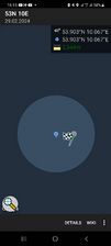
| Thu 29 Feb 2024 in 53,10: 53.9025002, 10.0667534 geohashing.info google osm bing/os kml crox |
Location
in a garden in Hartenholn, Schleswig-Holstein
Participants
Expedition
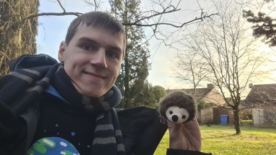
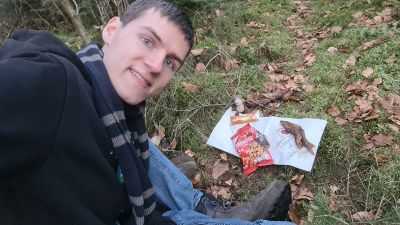
Leap hash! I couldn't let this opportunity slip by, especially considering the lengths I went to get to to reach the hash four years ago (yes, I know I still haven't written most of that report). So I took the train to Kaltenkirchen and then cycled to Hartenholm, where I finally made it to the hash on my third attempt after chickening out twice. Then I had a small picnic in the neighbouring forest and cycled home, ~35 km cycling distance in total. Detailed report following.
Photos
Close enough
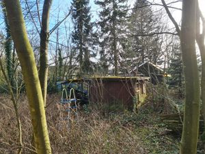
Garden from the back
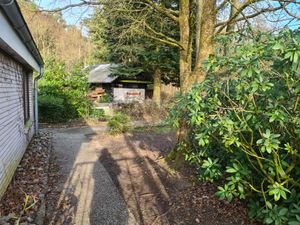
Garden from the front, almost dared to enter

So many weeds!
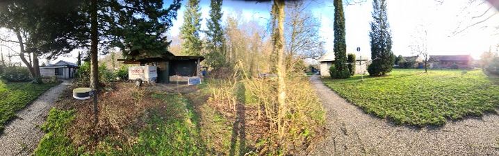
Didn't think I'd make it this far
One Giant Leap!
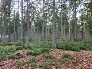
Segeberger Forst is here to calm the nerves
Callback to four years ago


Achievements
Land geohash, Public transport geohash, Bicycle geohash
