Difference between revisions of "2024-03-01 31 35"
Yerushalmi (talk | contribs) (Created page with "{{subst:Expedition}}") |
Yerushalmi (talk | contribs) |
||
| Line 13: | Line 13: | ||
}}<!-- edit as necessary --> | }}<!-- edit as necessary --> | ||
== Location == | == Location == | ||
| − | + | Two miles from my house, on the outskirts of the Har Herzl cemetery. | |
== Participants == | == Participants == | ||
| − | + | [[User:Yerushalmi|Yerushalmi]] ([[User talk:Yerushalmi|talk]]) | |
| − | |||
== Plans == | == Plans == | ||
| − | + | It's so rare that I can go on a Friday hash (I think the last time I did was in 2009), and even rare where I can realistically attempt one on Shabbat. So before Shabbat I'll print out the satellite photos, and after Friday night dinner the whole family, or at least as many of us as want to, will walk over to the cemetery - should be about a 45 minute walk - and try to reach the point. It's an opportunity for the no batteries, walk, holy (in the sense of time rather than space), and maybe even Tron achievements. | |
== Expedition == | == Expedition == | ||
| − | + | I was already concerned, the day before, that the cemetery would probably be closed at night. That morning I suddenly realized that even any exception to closing the cemetery - such as an active burial - could not take place on Shabbat. So I decided to scout it out in the morning, in advance of going to the shuk for Shabbat ingredients. I took the light rail to the Har Herzl station and walked over to the cemetery entrance. | |
| − | + | There was an opening hours sign there: The cemetery closes at 13:00 on Fridays. | |
| − | + | ||
| + | Oh well. The later expedition would have to be canceled; this is all I'll get. I walked in, reached the point with ease, and went back to the light rail station. | ||
== Photos == | == Photos == | ||
| − | < | + | <gallery> |
| − | + | File:Screenshot_20240301_091526_Geohash Droid.jpg | Proof | |
| − | + | File:20240301_091539.jpg | Panorama at the point | |
| − | |||
</gallery> | </gallery> | ||
| − | |||
| − | |||
| − | |||
| − | |||
__NOTOC__ | __NOTOC__ | ||
| − | |||
| − | |||
| − | |||
| − | |||
| − | |||
| − | |||
| − | |||
| − | |||
| − | |||
| − | |||
| − | |||
| − | |||
| − | |||
[[Category:Expeditions]] | [[Category:Expeditions]] | ||
| − | |||
[[Category:Expeditions with photos]] | [[Category:Expeditions with photos]] | ||
| − | |||
| − | |||
| − | |||
| − | |||
| − | |||
[[Category:Coordinates reached]] | [[Category:Coordinates reached]] | ||
| − | |||
| − | |||
| − | |||
| − | |||
| − | |||
| − | |||
| − | |||
| − | |||
| − | |||
| − | |||
| − | |||
| − | |||
| − | |||
| − | |||
| − | |||
| − | |||
| − | |||
| − | |||
Revision as of 13:53, 3 March 2024
| Fri 1 Mar 2024 in 31,35: 31.7740562, 35.1814308 geohashing.info google osm bing/os kml crox |
Location
Two miles from my house, on the outskirts of the Har Herzl cemetery.
Participants
Plans
It's so rare that I can go on a Friday hash (I think the last time I did was in 2009), and even rare where I can realistically attempt one on Shabbat. So before Shabbat I'll print out the satellite photos, and after Friday night dinner the whole family, or at least as many of us as want to, will walk over to the cemetery - should be about a 45 minute walk - and try to reach the point. It's an opportunity for the no batteries, walk, holy (in the sense of time rather than space), and maybe even Tron achievements.
Expedition
I was already concerned, the day before, that the cemetery would probably be closed at night. That morning I suddenly realized that even any exception to closing the cemetery - such as an active burial - could not take place on Shabbat. So I decided to scout it out in the morning, in advance of going to the shuk for Shabbat ingredients. I took the light rail to the Har Herzl station and walked over to the cemetery entrance.
There was an opening hours sign there: The cemetery closes at 13:00 on Fridays.
Oh well. The later expedition would have to be canceled; this is all I'll get. I walked in, reached the point with ease, and went back to the light rail station.
Photos

Proof
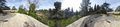
Panorama at the point
