Difference between revisions of "2024-03-13 51 5"
SomeDutchman (talk | contribs) (Created page with "{{subst:Expedition |lat = 51 |lon = 5 |date = 2024-03-13 }}") |
SomeDutchman (talk | contribs) |
||
| Line 1: | Line 1: | ||
| − | + | [[Image:2024-03-13 51 5 Proof.jpg|thumb|left]] | |
| − | + | {{meetup graticule | |
| − | |||
| − | |||
| − | |||
| − | |||
| − | |||
| − | |||
| lat=51 | | lat=51 | ||
| lon=5 | | lon=5 | ||
| Line 13: | Line 7: | ||
}}<!-- edit as necessary --> | }}<!-- edit as necessary --> | ||
== Location == | == Location == | ||
| − | + | In Nijmegen, directly next to a pond, close to the Steve Bikoplein. | |
== Participants == | == Participants == | ||
| − | + | [[User:SomeDutchman|SomeDutchman]] ([[User talk:SomeDutchman|talk]]) | |
| − | |||
== Plans == | == Plans == | ||
| − | + | Just cycle to it from my home. And make some pretty pictures. And tell a bit about where it was. | |
== Expedition == | == Expedition == | ||
| − | + | I've had push messages for geohashing since 2019, and this is the second time I've actually visited a place. (First time before the resurrection of the site...) | |
| + | |||
| + | The push notification said: "LocalHash is 1km away, South". Sounded perfect for a after-work-cycle-trip. And it was! Directly next to a pond, and it was a good reason to go outside. | ||
| − | + | The hash location was right next to the Steve Bikoplein, named after a South African anti-apartheid activist. It's one of the French-style traffic circles which makes Nijmegen famous in the Netherlands. What makes it French-style is you having to give way to people *entering* the circle... | |
| − | + | This one is kind of chill though, as at least it has road markings, while the most famous one, Keizer Karelplein, has no road markings at all! | |
== Photos == | == Photos == | ||
| − | |||
| − | |||
| − | |||
<gallery perrow="5"> | <gallery perrow="5"> | ||
| + | Image:2024-03-13 51 5 Cycling.jpg | Just after work, let's gooooo | ||
| + | Image:2024-03-13 51 5 Proof.jpg | Proof that I was here! | ||
| + | Image:2024-03-13 51 5 Looking east.jpg | Looking east. Now without GPS. You can just see restaurant 't Zusje behind the trees. | ||
| + | Image:2024-03-13 51 5 Looking north.jpg | Looking north. | ||
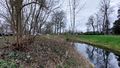
| + | Image:2024-03-13 51 5 Looking west.jpg | Looking west, you can just make out my bike. | ||
| + | Image:2024-03-13 51 5 Looking south.jpg | Looking south, not much to see here. | ||
| + | Image:2024-03-13 51 5 Steve Bikoplein.jpg | The aformentioned Steve Bikoplein, 100m from the hash. | ||
</gallery> | </gallery> | ||
== Achievements == | == Achievements == | ||
{{#vardefine:ribbonwidth|100%}} | {{#vardefine:ribbonwidth|100%}} | ||
| − | + | {{land geohash | |
| + | | latitude = 51 | ||
| + | | longitude = 5 | ||
| + | | date = 2024-03-13 | ||
| + | | name = SomeDutchman | ||
| + | | image = 2024-03-13 51 5 Proof.jpg | ||
| + | }} | ||
__NOTOC__ | __NOTOC__ | ||
| Line 43: | Line 48: | ||
Delete the next line ONLY if you have chosen the appropriate categories below. If you are unsure, don't worry. People will read your report and help you with the classification. --> | Delete the next line ONLY if you have chosen the appropriate categories below. If you are unsure, don't worry. People will read your report and help you with the classification. --> | ||
[[Category:New report]] | [[Category:New report]] | ||
| − | |||
| − | |||
| − | |||
| − | |||
| − | |||
| − | |||
| − | |||
| − | |||
| − | |||
| − | |||
| − | |||
[[Category:Expeditions]] | [[Category:Expeditions]] | ||
| − | |||
[[Category:Expeditions with photos]] | [[Category:Expeditions with photos]] | ||
| − | |||
| − | |||
| − | |||
| − | |||
| − | |||
[[Category:Coordinates reached]] | [[Category:Coordinates reached]] | ||
| − | |||
| − | |||
| − | |||
| − | |||
| − | |||
| − | |||
| − | |||
| − | |||
| − | |||
| − | |||
| − | |||
| − | |||
| − | |||
| − | |||
| − | |||
| − | |||
| − | |||
| − | |||
Revision as of 19:04, 13 March 2024

| Wed 13 Mar 2024 in 51,5: 51.8161116, 5.8042720 geohashing.info google osm bing/os kml crox |
Location
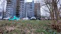
In Nijmegen, directly next to a pond, close to the Steve Bikoplein.
Participants
Plans
Just cycle to it from my home. And make some pretty pictures. And tell a bit about where it was.
Expedition
I've had push messages for geohashing since 2019, and this is the second time I've actually visited a place. (First time before the resurrection of the site...)
The push notification said: "LocalHash is 1km away, South". Sounded perfect for a after-work-cycle-trip. And it was! Directly next to a pond, and it was a good reason to go outside.
The hash location was right next to the Steve Bikoplein, named after a South African anti-apartheid activist. It's one of the French-style traffic circles which makes Nijmegen famous in the Netherlands. What makes it French-style is you having to give way to people *entering* the circle... This one is kind of chill though, as at least it has road markings, while the most famous one, Keizer Karelplein, has no road markings at all!
Photos
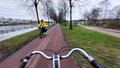
Just after work, let's gooooo
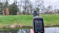
Proof that I was here!
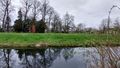
Looking east. Now without GPS. You can just see restaurant 't Zusje behind the trees.
Looking north.
Looking west, you can just make out my bike.
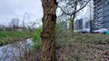
Looking south, not much to see here.
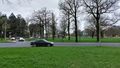
The aformentioned Steve Bikoplein, 100m from the hash.


Achievements
SomeDutchman earned the Land geohash achievement
|