Difference between revisions of "2024-03-16 28 -82"
From Geohashing
m (Location) |
|||
| Line 4: | Line 4: | ||
| date=2024-03-16 | | date=2024-03-16 | ||
}} | }} | ||
| + | == Location == | ||
| + | A grassy berm between the sidewalk and Cortez Boulevard in Spring Hill, Florida | ||
| + | |||
| + | == Participants == | ||
| + | *[[User:Improv|Improv]] | ||
| + | |||
| + | == Plans == | ||
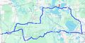
| + | Two GeoHashes in one day using a route calculated as if I was bicycling (est 15.5 hours for 186 miles) using my car (approx 4.5 hours for 173 miles) | ||
| + | |||
| + | == Expedition == | ||
| + | |||
| + | |||
| + | == Photos == | ||
| + | <gallery perrow="5"> | ||
| + | <gallery> | ||
| + | File:Image 20240316 28 -81 Improv-1.jpg|thumb|The Plan | ||
| + | <!-- Image:Image 20240305 161051 240.jpg | As close as we could get--> | ||
| + | </gallery> | ||
| + | |||
| + | ==Ribbons== | ||
| + | <!-- {{no trespassing|date=2024-03-03|latitude=28|longitude=-82|name=[[User:Improv|Improv]]|distance=one-tenth of a mile}} --> | ||
| + | |||
| + | __NOTOC__ | ||
| + | [[Category:Expeditions]] | ||
| + | <!-- [[Category:Expeditions with photos]] --> | ||
{{location|US|FL|HA}} | {{location|US|FL|HA}} | ||
Revision as of 20:29, 17 March 2024
| Sat 16 Mar 2024 in 28,-82: 28.5336939, -82.4858968 geohashing.info google osm bing/os kml crox |
Location
A grassy berm between the sidewalk and Cortez Boulevard in Spring Hill, Florida
Participants
Plans
Two GeoHashes in one day using a route calculated as if I was bicycling (est 15.5 hours for 186 miles) using my car (approx 4.5 hours for 173 miles)
Expedition
Photos
The Plan
