Difference between revisions of "2024-03-19 55 -4"
m |
m |
||
| Line 40: | Line 40: | ||
| width="100px" | [[File:Arrow7.png|12px]] [[2024-03-17 55 -4|Previous]] | | width="100px" | [[File:Arrow7.png|12px]] [[2024-03-17 55 -4|Previous]] | ||
| width="150px" | [[User:KerrMcF|KerrMcF]]'s expeditions | | width="150px" | [[User:KerrMcF|KerrMcF]]'s expeditions | ||
| − | | width="100px" | | + | | width="100px" | [[2024-03-22 56 -4|Next]] [[File:Arrow1.png|12px]] |
|- | |- | ||
| bgcolor=oldlace | [[File:Arrow7.png|12px]] [[2024-03-17 55 -4|Previous]] | | bgcolor=oldlace | [[File:Arrow7.png|12px]] [[2024-03-17 55 -4|Previous]] | ||
Revision as of 02:48, 23 March 2024
| Tue 19 Mar 2024 in 55,-4: 55.8534943, -4.2558330 geohashing.info google osm bing/os kml crox |
Contents
Location
In Glasgow City Centre. Looks like it might be on a small construction site.
Participants
Plans
KerrMcF
I'll be in Glasgow's West End for university during the day, so the short journey into the centre makes this geohash very appealing. It's potentially in a fenced-off area that has been that way since at least 2008. The site may have been finished/opened within the past 10 months, but it feels unlikely. If there is anyone working on the site when I arrive I will ask them if I can either enter to reach the point or if they could do so on my behalf.
Expedition
KerrMcF
So, Daniel and I got a bus from the university to a nearby bus stop and began walking to the point. We weren't expecting much, and when we could see the general area the surrounding fence was still visible. However, when we turned the corner onto Oxford Street, we saw that the gate to the area was open. There were several cars parked inside of the area and there was no construction work going on. The sign said "Caution: Site Entrance" but did not seem to indicate that the area was not for public access. We hesitantly went into the site to see what we could find, but realised that the point was amongst quite heavy tree growth. We didn't attempt the point which was slightly annoying as, although I had expected a failure due to restricted access, it was just because of general inaccessibility.
Turning from Oxford Street onto Southportland Street, I remembered seeing a sign previously on street view and wanted to check if it was still there. Sure enough, a "Construction Site: Keep Out" sign could be seen at the end of a nearby lane. Now, it's unclear to me whether that sign referred to the site we entered or whether it was just an adjacent site. We couldn't check in person as someone was moving things in the lane and we didn't want to bother them, but when looking again at the street view it appears to have a fence between that section and the area containing the geohash point.
Either way, the expedition was unsuccessful. We either accidentally "trespassed" through an open gate with no restricted access signage and left after 30 seconds or so, or we just didn't make it due to the trees blocking our path. I'm not sure how to truthfully mark this expedition, but I'll say that the specific area we were in was not restricted and that nature got in the way of completing the expedition. I took a photo of a police van parked directly opposite the site for the Police achievement, at least the expedition was worth something. (The police van was not stationed there to prevent trespassing on the site, it just happens to be that the Glasgow Sheriff Court is at the end of the street).
Photos

Bus to the point
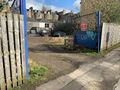
Open gate to the area
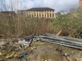
Trees!
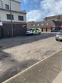
Police van next to the point
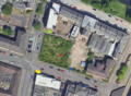
Map of the area.
Red is the point, blue is the gate entrance, yellow is the police van, green is the lane with the Keep Out sign


Achievements
KerrMcF and Daniel earned the Police Geohash Achievement
|
| Expedition Navigation | ||
|---|---|---|
| KerrMcF's expeditions | Next | |
| Daniel's expeditions | No Next Yet | |