Difference between revisions of "2024-03-24 47 -122"
From Geohashing
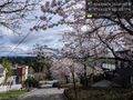
Coyotebush (talk | contribs) ([live picture]View from southeast [https://openstreetmap.org/?mlat=47.63024167&mlon=-122.30149444&zoom=16 @47.6302,-122.3015]) |
Coyotebush (talk | contribs) ([live picture]Looking east [https://openstreetmap.org/?mlat=47.63028056&mlon=-122.30176944&zoom=16 @47.6303,-122.3018]) |
||
| Line 50: | Line 50: | ||
Image:2024-03-24_47_-122_coyotebush_1711317681473.jpg|View from southeast [https://openstreetmap.org/?mlat=47.63024167&mlon=-122.30149444&zoom=16 @47.6302,-122.3015] | Image:2024-03-24_47_-122_coyotebush_1711317681473.jpg|View from southeast [https://openstreetmap.org/?mlat=47.63024167&mlon=-122.30149444&zoom=16 @47.6302,-122.3015] | ||
| + | |||
| + | Image:2024-03-24_47_-122_coyotebush_1711317744134.jpg|Looking east [https://openstreetmap.org/?mlat=47.63028056&mlon=-122.30176944&zoom=16 @47.6303,-122.3018] | ||
</gallery> | </gallery> | ||
Revision as of 22:02, 24 March 2024
| Sun 24 Mar 2024 in Seattle: 47.6304644, -122.3016494 geohashing.info google osm bing/os kml crox |
Location
Middle of 24th Ave E in eastern Capitol Hill
Participants
Plans
- Bike. Either around noon directly from morning plans, or mid-afternoon from home. Coyotebush (talk) 19:02, 23 March 2024 (UTC)
Expedition
- Lunch nearby first -- Coyotebush (talk) @47.6398,-122.3023 12:12, 24 March 2024 (PDT)
Tracklog
Photos
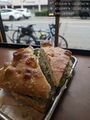
Sandwich and bicycle @47.6399,-122.3024
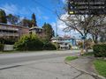
View from northwest (point is between the two turn arrows)
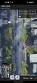
Middle of the road screenshot
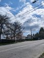
View from southeast @47.6302,-122.3015
Looking east @47.6303,-122.3018


Achievements