Difference between revisions of "2024-03-24 47 -122"
Coyotebush (talk | contribs) ([live picture]Very belated selfie [https://openstreetmap.org/?mlat=47.65248333&mlon=-122.32047778&zoom=16 @47.6525,-122.3205]) |
Coyotebush (talk | contribs) (→Expedition) |
||
| Line 30: | Line 30: | ||
== Expedition == | == Expedition == | ||
| − | + | Intermittent sun throughout the morning, gradually warming up. Not seeing any other interest in this point, I figured as long as I was out and about, I might as well take the opportunity for a loop route and lunch in a new neighborhood. | |
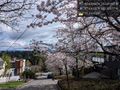
| + | Near the University of Washington campus, I encountered evidence of a running event - apparently the Cherry Blossom Run. Indeed, Seattle neighborhood streets are beautiful right now with blooming cherry, plum, magnolia, and such. Dodged a bunch of pedestrians likely visiting UW's famous cherry trees before navigating through the long-running construction at the Montlake/520 interchange. | ||
| + | |||
| + | Next a cafe stop in the Montlake neighborhood's small business district (which also contains a good bike shop). Ate a sandwich there and took a treat for later. | ||
*Lunch nearby first -- [[User:Coyotebush|Coyotebush]] ([[User talk:Coyotebush|talk]]) [https://openstreetmap.org/?mlat=47.63979199&mlon=-122.30231290&zoom=16 @47.6398,-122.3023] 12:12, 24 March 2024 (PDT) | *Lunch nearby first -- [[User:Coyotebush|Coyotebush]] ([[User talk:Coyotebush|talk]]) [https://openstreetmap.org/?mlat=47.63979199&mlon=-122.30231290&zoom=16 @47.6398,-122.3023] 12:12, 24 March 2024 (PDT) | ||
| + | |||
| + | Then it was a straight shot uphill on 4-lane 24th Ave E. A surprisingly challenging climb. There was steady traffic coming the other way, but little enough in my direction that cars *could* easily change lanes to pass me... not that all of them fully did. | ||
| + | |||
| + | I pulled over just before E Highland Dr, then realized I could legitimately use the center turn lane for a left turn there. While doing so I carefully paused to sneak a screenshot. Admired some views, but a selfie completely slipped my mind until much later. | ||
| + | |||
| + | Escaped the traffic temporarily via Interlaken Blvd, including the section closed to cars. | ||
| + | |||
== Tracklog == | == Tracklog == | ||
<!-- if your GPS device keeps a log, you may use Template:Tracklog, post a link here, or both --> | <!-- if your GPS device keeps a log, you may use Template:Tracklog, post a link here, or both --> | ||
Revision as of 22:54, 24 March 2024
| Sun 24 Mar 2024 in Seattle: 47.6304644, -122.3016494 geohashing.info google osm bing/os kml crox |
Location
Middle of 24th Ave E in eastern Capitol Hill
Participants
Plans
- Bike. Either around noon directly from morning plans, or mid-afternoon from home. Coyotebush (talk) 19:02, 23 March 2024 (UTC)
Expedition
Intermittent sun throughout the morning, gradually warming up. Not seeing any other interest in this point, I figured as long as I was out and about, I might as well take the opportunity for a loop route and lunch in a new neighborhood.
Near the University of Washington campus, I encountered evidence of a running event - apparently the Cherry Blossom Run. Indeed, Seattle neighborhood streets are beautiful right now with blooming cherry, plum, magnolia, and such. Dodged a bunch of pedestrians likely visiting UW's famous cherry trees before navigating through the long-running construction at the Montlake/520 interchange.
Next a cafe stop in the Montlake neighborhood's small business district (which also contains a good bike shop). Ate a sandwich there and took a treat for later.
- Lunch nearby first -- Coyotebush (talk) @47.6398,-122.3023 12:12, 24 March 2024 (PDT)
Then it was a straight shot uphill on 4-lane 24th Ave E. A surprisingly challenging climb. There was steady traffic coming the other way, but little enough in my direction that cars *could* easily change lanes to pass me... not that all of them fully did.
I pulled over just before E Highland Dr, then realized I could legitimately use the center turn lane for a left turn there. While doing so I carefully paused to sneak a screenshot. Admired some views, but a selfie completely slipped my mind until much later.
Escaped the traffic temporarily via Interlaken Blvd, including the section closed to cars.
Tracklog
Photos
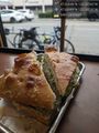
Sandwich and bicycle @47.6399,-122.3024
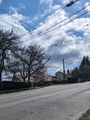
View from northwest (point is between the two turn arrows)
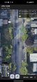
Middle of the road screenshot
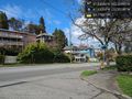
View from southeast @47.6302,-122.3015
Looking east @47.6303,-122.3018
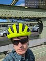
Very belated selfie @47.6525,-122.3205


Achievements