Difference between revisions of "2024-03-25 29 -81"
From Geohashing
m |
|||
| (6 intermediate revisions by one other user not shown) | |||
| Line 11: | Line 11: | ||
== Plans == | == Plans == | ||
| − | Grab some lunch, then | + | Grab some lunch, then drive up to the closest point to the hash point, then walk in |
| + | |||
| + | == Expedition == | ||
| + | *Lunch - Check | ||
| + | *Drive up - Check - I even drove by the airport and hashpoint from 2024-03-22 29 -81 that I didn't do | ||
| + | *Walk in - Well ... | ||
| + | : really more like climb and stumble in. It's springtime in Florida and the wild grapes and palmettos are full of new and thick growth. Not to mention 4-6" of leaves on the ground and fallen trees. I fought through all of that until I reached the end of the tree trunk I was using for balance and noticed a drop-off ahead. Looking toward it, I could see water in the bottom and it didn't look shallow --- swim the slough to go the other sixty feet? Nope, not happening. I looked northeast and southwest but couldn't see how far it extended. Rather than wander the woods further, I started the slog back out. Somehow, it seemed shorter going out but the grapevines were more dense. On multiple occasions, I lifted them up to go under as it was easier than pressing them down to go over. | ||
| + | : When I reached my car, I felt like something was moving in my shoe, so I took them off while driving. When I reached my next stop and needed to put them back on, I pulled the insert out to shake them out. Attached to the top of the insole was a tick. I instantly felt like more things were crawling on me. After a thorough check, that feeling was proven to be hypochondria. | ||
| + | |||
| + | == Pictures == | ||
| + | [[Image:2024-03-25-29 -81 Improv-1.jpg|thumb|Done with Nature - Foiled by a slough]] | ||
| + | |||
| + | |||
| + | |||
| + | |||
__NOTOC__ | __NOTOC__ | ||
[[Category:Expeditions]] | [[Category:Expeditions]] | ||
[[Category:Coordinates not reached]] | [[Category:Coordinates not reached]] | ||
| + | [[Category:Not reached - Mother Nature]] | ||
| + | [[Category:Expeditions_with_ticks]] | ||
{{location|US|FL|MI}} | {{location|US|FL|MI}} | ||
Revision as of 23:16, 26 March 2024
| Mon 25 Mar 2024 in 29,-81: 29.2179857, -81.8718809 geohashing.info google osm bing/os kml crox |
Location
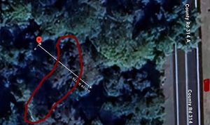
130' into the woods off FL-314A in the Ocala National Forest, Florida
Participants
Plans
Grab some lunch, then drive up to the closest point to the hash point, then walk in
Expedition
- Lunch - Check
- Drive up - Check - I even drove by the airport and hashpoint from 2024-03-22 29 -81 that I didn't do
- Walk in - Well ...
- really more like climb and stumble in. It's springtime in Florida and the wild grapes and palmettos are full of new and thick growth. Not to mention 4-6" of leaves on the ground and fallen trees. I fought through all of that until I reached the end of the tree trunk I was using for balance and noticed a drop-off ahead. Looking toward it, I could see water in the bottom and it didn't look shallow --- swim the slough to go the other sixty feet? Nope, not happening. I looked northeast and southwest but couldn't see how far it extended. Rather than wander the woods further, I started the slog back out. Somehow, it seemed shorter going out but the grapevines were more dense. On multiple occasions, I lifted them up to go under as it was easier than pressing them down to go over.
- When I reached my car, I felt like something was moving in my shoe, so I took them off while driving. When I reached my next stop and needed to put them back on, I pulled the insert out to shake them out. Attached to the top of the insole was a tick. I instantly felt like more things were crawling on me. After a thorough check, that feeling was proven to be hypochondria.
