Difference between revisions of "2024-03-28 32 35"
Yerushalmi (talk | contribs) (Created page with "{{subst:Expedition}}") |
Yerushalmi (talk | contribs) |
||
| Line 13: | Line 13: | ||
}}<!-- edit as necessary --> | }}<!-- edit as necessary --> | ||
== Location == | == Location == | ||
| − | + | In a field northwest of Afula. | |
== Participants == | == Participants == | ||
| − | + | [[User:Yerushalmi|Yerushalmi]] ([[User talk:Yerushalmi|talk]]) 11:59, 31 March 2024 (UTC) | |
| − | |||
== Plans == | == Plans == | ||
| − | + | Train day, simple enough. I have to go to Haifa anyway to drop off my wife's artwork, so I'll take a further train from there to Afula, then take a bus to the area, walk to the point, do the reverse to get home. | |
== Expedition == | == Expedition == | ||
| − | + | I had enormous trouble sleeping the night before - in fact, I don't think I slept at all. This did not bode well. | |
| − | + | But the rest of the expedition went almost without a hitch. I took the train to Tel Aviv (davening Shacharit with the train minyan), then the train to Haifa. I walked from the train station to the art gallery, dropped off the artwork, and walked back. | |
| − | |||
| − | + | Haifa is, as always, GPS-jammed. This gave me some trouble using Moovit, but not too much trouble. I took a train *not* to Afula but rather to Kfar Yehoshua, and from there one bus to another bus to Ginigar Intersection north of the point, Ginigar being some very small town I've never heard of. | |
| − | + | ||
| − | + | Moovit estimated a 77-minute walk to the point, which is among the longest I've done. But it was a mostly-straight walk down a mostly-straight road between the fields. Every ten minutes or so a massive truck would go by and I'd have to stand on the side of the road to let it pass; they were all going back and forth to the same place off in the distance and dumping something, but I couldn't see what. | |
| − | + | ||
| − | + | Eventually I reached the field I needed to enter - hoping against home that it wouldn't be covered in crops - and to my delight it was not! The earth was dark brown, clearly freshly turned, and hard as a rock. Not only that, but there was a path *within* the field that led directly to the point! | |
| − | |||
| − | + | Well, not directly, as I discovered when I walked down it. I had to go about five steps off to the right when I reached the area of the point. But still, successful reaching of the coordinates. | |
| − | |||
| − | |||
| − | + | Unfortunately, this place is even more middle-of-nowhere than my usual hashes. So I couldn't take the train back home, or I wouldn't reach Jerusalem in time to pick up #3 from her after-school program. I ended up taking the bus, and falling asleep almost immediately. Then getting woken up by phone call after phone call for the next twenty minutes. Not a single call the entire time I'm in the field, but when I'm trying to sleep? Typical. | |
| − | |||
| − | |||
| − | |||
| − | + | Eh, there was still plenty of time on the long bus ride. I slept the rest of the way. Massive traffic jam at the entrance to Jerusalem. | |
| + | |||
| + | == Photos == | ||
| + | <gallery> | ||
| + | File:20240328_114018.jpg | The view from above the platform at Kfar Yehoshua train station | ||
| + | File:20240328_115958.jpg | The main path between the fields leading towards the point | ||
| + | File:20240328_120738.jpg | Some kind of lake or reservoir | ||
| + | File:20240328_120741.jpg | Same lake | ||
| + | File:20240328_121203.jpg | Half-panorama at the lake | ||
| + | File:20240328_121218.jpg | Three-quarters panorama at the lake | ||
| + | File:20240328_121339.jpg | Apparently the path I've been walking is an official hiking path | ||
| + | File:20240328_121616.jpg | The path to the left, to the point, is a concrete bridge over a creek on the left. The sign claims (rather dubiously) that the path to the right is a major highway. | ||
| + | File:20240328_121635.jpg | The creek under the bridge | ||
| + | File:20240328_123250.jpg | The point is in this field somewhere. No crops! | ||
| + | File:20240328_123508.jpg | A sort of half-road-thing, in the middle of the field, going straight to the point | ||
| + | File:Screenshot_20240328_123657_Geohash Droid.jpg | Proof | ||
| + | File:20240328_123708.jpg | Panorama at the point | ||
| + | File:20240328_164015.jpg | An amusing glitch on the sign on the bus when we got to Jerusalem | ||
| + | </gallery> | ||
| − | |||
| − | |||
| − | |||
| − | |||
| − | |||
| − | |||
[[Category:Expeditions]] | [[Category:Expeditions]] | ||
| − | |||
[[Category:Expeditions with photos]] | [[Category:Expeditions with photos]] | ||
| − | |||
| − | |||
| − | |||
| − | |||
| − | |||
[[Category:Coordinates reached]] | [[Category:Coordinates reached]] | ||
| − | |||
| − | |||
| − | |||
| − | |||
| − | |||
| − | |||
| − | |||
| − | |||
| − | |||
| − | |||
| − | |||
| − | |||
| − | |||
| − | |||
| − | |||
| − | |||
| − | |||
| − | |||
Revision as of 11:59, 31 March 2024
| Thu 28 Mar 2024 in 32,35: 32.6415694, 35.2576104 geohashing.info google osm bing/os kml crox |
Contents
Location
In a field northwest of Afula.
Participants
Yerushalmi (talk) 11:59, 31 March 2024 (UTC)
Plans
Train day, simple enough. I have to go to Haifa anyway to drop off my wife's artwork, so I'll take a further train from there to Afula, then take a bus to the area, walk to the point, do the reverse to get home.
Expedition
I had enormous trouble sleeping the night before - in fact, I don't think I slept at all. This did not bode well.
But the rest of the expedition went almost without a hitch. I took the train to Tel Aviv (davening Shacharit with the train minyan), then the train to Haifa. I walked from the train station to the art gallery, dropped off the artwork, and walked back.
Haifa is, as always, GPS-jammed. This gave me some trouble using Moovit, but not too much trouble. I took a train *not* to Afula but rather to Kfar Yehoshua, and from there one bus to another bus to Ginigar Intersection north of the point, Ginigar being some very small town I've never heard of.
Moovit estimated a 77-minute walk to the point, which is among the longest I've done. But it was a mostly-straight walk down a mostly-straight road between the fields. Every ten minutes or so a massive truck would go by and I'd have to stand on the side of the road to let it pass; they were all going back and forth to the same place off in the distance and dumping something, but I couldn't see what.
Eventually I reached the field I needed to enter - hoping against home that it wouldn't be covered in crops - and to my delight it was not! The earth was dark brown, clearly freshly turned, and hard as a rock. Not only that, but there was a path *within* the field that led directly to the point!
Well, not directly, as I discovered when I walked down it. I had to go about five steps off to the right when I reached the area of the point. But still, successful reaching of the coordinates.
Unfortunately, this place is even more middle-of-nowhere than my usual hashes. So I couldn't take the train back home, or I wouldn't reach Jerusalem in time to pick up #3 from her after-school program. I ended up taking the bus, and falling asleep almost immediately. Then getting woken up by phone call after phone call for the next twenty minutes. Not a single call the entire time I'm in the field, but when I'm trying to sleep? Typical.
Eh, there was still plenty of time on the long bus ride. I slept the rest of the way. Massive traffic jam at the entrance to Jerusalem.
Photos
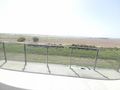
The view from above the platform at Kfar Yehoshua train station
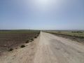
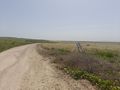
The main path between the fields leading towards the point
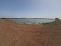
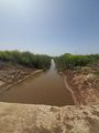
Some kind of lake or reservoir
Same lake
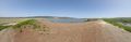
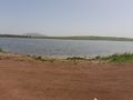
Half-panorama at the lake
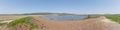
Three-quarters panorama at the lake
Apparently the path I've been walking is an official hiking path
The path to the left, to the point, is a concrete bridge over a creek on the left. The sign claims (rather dubiously) that the path to the right is a major highway.
The creek under the bridge
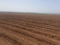
The point is in this field somewhere. No crops!
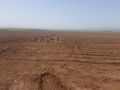
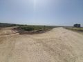
A sort of half-road-thing, in the middle of the field, going straight to the point

Proof
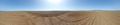
Panorama at the point
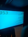
An amusing glitch on the sign on the bus when we got to Jerusalem


