2024-03-29 46 -124

| Fri 29 Mar 2024 in 46,-124: 46.2265380, -124.0006484 geohashing.info google osm bing/os kml crox |
Location
Near the mouth of the Columbia.
Participants
Expedition
Over breakfast I pointed out that there was a hashpoint on the speck of land that Oregon pokes into the Ocean Shores, Washington graticule. "Will we get it?" asked Mrs.5000. "Oh, well," I said, "workday blah blah blah pretty worn out blah blah blah," but was made to understand that that was kind of a boring answer.
"I want that hashpoint," said Mrs.5000.
So it was that I let my new boss know I'd be ducking out a little early ("pretty worn out blah blah blah"), and Mrs. and myself hit the road. Specifically, we hit US 30, which winds through forests and occasional little towns in the lowest 100 miles of the Columbia River, 50 miles north from Portland to find a gap through the coast range and then a straight shot 50 miles west to the Pacific.
From Astoria, we passed through Warrenton and Hammond and then followed the wide sand spit up to the South Jetty area. We parked near the hashpoint -- but in the Astoria graticule -- then wandered about 200 meters through forest and a little bit of marshland, crossing 124 W longitude on the way, to get to ground zero. And there we were!
A herd of elk was hanging out on the road on the way back out, but they got the hint and let us by. We had dinner in Seaside, and drove through the night to get back home.
Photos

100 miles in, 200 meters to go

We made it!

This expedition was hashcot-certified.
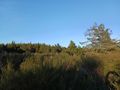
Looking northeast.
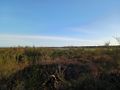
Looking southwest.
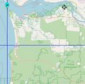
Clatsop County.


Achievements