Difference between revisions of "2024-04-04 31 34"
Yerushalmi (talk | contribs) (Created page with "{{subst:Expedition}}") |
Yerushalmi (talk | contribs) |
||
| Line 13: | Line 13: | ||
}}<!-- edit as necessary --> | }}<!-- edit as necessary --> | ||
== Location == | == Location == | ||
| − | + | In a orchard near the town of Nitzan B. | |
== Participants == | == Participants == | ||
| − | + | [[User:Yerushalmi|Yerushalmi]] ([[User talk:Yerushalmi|talk]]) | |
| − | |||
== Plans == | == Plans == | ||
| − | + | Train day! I have to drop off my wife's artwork in Tel Aviv as usual, so I'll take the train to Tel Aviv, go to the gallery and back, then train to Ashdod. Bus to the Eshkolit Intersection, walk 20-ish minutes to the point, do the reverse to go home. | |
== Expedition == | == Expedition == | ||
| − | + | The first part of the plan worked well - all the way to Eshkolit Intersection. | |
| − | + | Here's Eshkolit Intersection, where the red Route 4 meets the orange Route 232: | |
| − | |||
| − | + | [[File:Eshkolit 20240404.png|400px]] | |
| − | |||
| − | |||
| − | |||
| − | |||
| − | |||
| − | + | The checkered north-south route to the west of Route 4 is the Tel Aviv-Ashkelon train line. Which I obviously can't cross except in designated places. That's okay, though, just to the north of Eshkolit Intersection there's a desig....nated.... | |
| − | |||
| − | |||
| − | + | [[File:20240404_115930.jpg|400px]] | |
| − | |||
| − | |||
| − | [[ | ||
| − | + | Ah, dammit. | |
| − | + | I spent a long time at that train crossing, reading all the signs carefully, trying to figure out if the warnings were only against cars crossing or if the pedestrian crossing (which was physically open) was safe. Eventually I decided against it. But the question is, where's the next crossing? | |
| − | |||
| − | |||
| − | |||
| − | + | An hour's walk. In each direction. (How do people ''live'' in that town?) Time for a new plan: take a bus to another bus to the town. This will take... also an hour, due to the time I have to wait between the buses, but I'll be less exhausted. This I did. | |
| − | + | As the bus approached the town, I saw that the orchard was entirely surrounded by fences and got nervous that the point would turn out to be inaccessible after all. But when I got off at the stop, I saw an opening in the fence that was clearly deliberately - and, most importantly, no no-trespassing signs. | |
| − | |||
| − | |||
| − | |||
| − | |||
| − | |||
| − | |||
| − | |||
| − | |||
| − | |||
| + | As I always do when geohashing in an orchard, I switched my phone to play my podcasts on speaker, at full volume, so that if anybody was working in another row they wouldn't think I was trying to sneak around. But nobody was; I walked to the point, then back to the bus stop, with no issues. | ||
| − | - | + | Annoyingly, I then discovered that the bus that went to the town went straight to the train station - so I could've taken that bus in the first place rather than the one that landed me on the other side of the train tracks, and saved myself over three hours of wasted time. Ah well. |
| − | |||
| − | |||
| − | |||
| − | |||
| − | |||
| − | |||
| − | |||
| − | + | == Photos == | |
| − | + | <gallery> | |
| − | + | File:20240404_133527.jpg | Panorama at the point | |
| − | + | File:Screenshot_20240404_133515_Geohash Droid.jpg | Proof | |
| − | + | </gallery> | |
| − | + | [[Category:Expeditions]] | |
| + | [[Category:Expeditions with photos]] | ||
| + | [[Category:Coordinates reached]] | ||
Revision as of 10:15, 7 April 2024
| Thu 4 Apr 2024 in 31,34: 31.7278463, 34.6310152 geohashing.info google osm bing/os kml crox |
Contents
Location
In a orchard near the town of Nitzan B.
Participants
Plans
Train day! I have to drop off my wife's artwork in Tel Aviv as usual, so I'll take the train to Tel Aviv, go to the gallery and back, then train to Ashdod. Bus to the Eshkolit Intersection, walk 20-ish minutes to the point, do the reverse to go home.
Expedition
The first part of the plan worked well - all the way to Eshkolit Intersection.
Here's Eshkolit Intersection, where the red Route 4 meets the orange Route 232:

The checkered north-south route to the west of Route 4 is the Tel Aviv-Ashkelon train line. Which I obviously can't cross except in designated places. That's okay, though, just to the north of Eshkolit Intersection there's a desig....nated....

Ah, dammit.
I spent a long time at that train crossing, reading all the signs carefully, trying to figure out if the warnings were only against cars crossing or if the pedestrian crossing (which was physically open) was safe. Eventually I decided against it. But the question is, where's the next crossing?
An hour's walk. In each direction. (How do people live in that town?) Time for a new plan: take a bus to another bus to the town. This will take... also an hour, due to the time I have to wait between the buses, but I'll be less exhausted. This I did.
As the bus approached the town, I saw that the orchard was entirely surrounded by fences and got nervous that the point would turn out to be inaccessible after all. But when I got off at the stop, I saw an opening in the fence that was clearly deliberately - and, most importantly, no no-trespassing signs.
As I always do when geohashing in an orchard, I switched my phone to play my podcasts on speaker, at full volume, so that if anybody was working in another row they wouldn't think I was trying to sneak around. But nobody was; I walked to the point, then back to the bus stop, with no issues.
Annoyingly, I then discovered that the bus that went to the town went straight to the train station - so I could've taken that bus in the first place rather than the one that landed me on the other side of the train tracks, and saved myself over three hours of wasted time. Ah well.
Photos
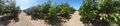
Panorama at the point

Proof
