Difference between revisions of "2024-04-21 45 11"
(text, no photos yet (success!)) |
(photos + categories) |
||
| Line 24: | Line 24: | ||
== Photos == | == Photos == | ||
| − | |||
<!--Insert pictures between the gallery tags using the following format: | <!--Insert pictures between the gallery tags using the following format: | ||
Image:2020-##-## ## ## Alpha.jpg | Witty Comment--> | Image:2020-##-## ## ## Alpha.jpg | Witty Comment--> | ||
<gallery perrow="5"> | <gallery perrow="5"> | ||
| + | Image:2024-04-21 45 11 hash road.jpeg | road of the geohash | ||
| + | Image:2024-04-21 45 11 marker.jpeg | the [[User:XXOs/Marker|geohash marker]] | ||
| + | Image:2024-04-21 45 11 tower.jpeg | neat tower visible from near the hash | ||
| + | Image:2024-04-21 45 11 goog.png | the 🌌 is in reference to [https://xkcd.com/2131/ xkcd 2131] | ||
| + | Image:2024-04-21 45 11 watch.jpeg | temporal proof ft. slight homesickness | ||
</gallery> | </gallery> | ||
| Line 42: | Line 46: | ||
__NOTOC__ | __NOTOC__ | ||
| − | |||
| − | |||
| − | |||
| − | |||
| − | |||
| − | |||
[[Category:Expeditions]] | [[Category:Expeditions]] | ||
| − | + | [[Category:Expeditions with photos]] | |
| − | [[Category:Expeditions with photos]] | ||
| − | |||
| − | |||
| − | |||
| − | |||
| − | |||
[[Category:Coordinates reached]] | [[Category:Coordinates reached]] | ||
| − | |||
| − | |||
| − | |||
| − | |||
| − | |||
| − | |||
| − | |||
| − | |||
| − | |||
| − | |||
| − | |||
| − | |||
| − | |||
| − | |||
| − | |||
| − | |||
| − | |||
| − | |||
{{location|IT|VN}} | {{location|IT|VN}} | ||
Revision as of 15:03, 21 April 2024
| Sun 21 Apr 2024 in 45,11: 45.2448582, 11.7472927 geohashing.info google osm bing/os kml crox |
Location
Near the train station in Monselice
Participants
Plans
I’m in Europe on a family holiday, and it just so happens that I’m going to be travelling from Padova to Bologna today!
This hash looks pretty easy to get, too - it’s on a road next to a train station! All I need to do is convince my parents to let me stop there to get the hash. Fingers crossed.
Expedition
Success! Like I expected, it was pretty easy - given that it was near the train station, we were able to park just a few metres away and then taking a few steps.
Unfortunately I didn’t have my hashscot with me this time, but I did have a new geohashing marker that I was able to stick on a nearby drain pipe.
Monselice is quite a pretty town, but unfortunately we weren’t able to stay for much longer because it was a relatively impromptu stop along the way to Bologna.
Photos
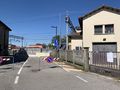
road of the geohash
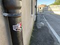
the geohash marker
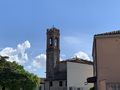
neat tower visible from near the hash
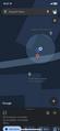
the 🌌 is in reference to xkcd 2131
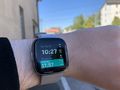
temporal proof ft. slight homesickness


Achievements
XXOs earned the Globetrotter achievement
|